| Home | Welcome | What's New | Site Map | Glossary | Weather Doctor Amazon Store | Book Store | Accolades | Email Us |
 | ||||||||||||||||||||||||
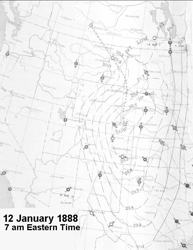
A Terrible Degree of Cold: The Cold Wave of 1888A Terrible Degree of Cold well describes the weather conditions that followed the infamous Children's Blizzard of January 1888 beginning in Montana on 12 January. After the passage of the low pressure system, a large arctic high surged southward, filling the northern American Plains states with intensely cold air behind the cold front, it then continued southeastward to touch most of the American territory east of the Rocky Mountain cordillera. In the following days the cold air would rush down to the Gulf Coast and spread into the Great Lakes. The heavy, frigid air mass was so cold and robust that the arctic air pushed across Texas into Mexico, through Veracruz, and across the Isthmus of Tehuantepec into the Pacific waters of the Gulf of Tehuantepec. The result was the great cold wave of 1888. The cold air descended first into Montana on the 12th. At Helena, during the early hours, the temperature had registered 40.5 oF (4.7 oC) before it began to free-fall. Four and a half hours later, the thermometer had registered a 49.5 F degree (27.5 C degree) drop to minus 9 oF (minus 22.8 oC). By 10 pm that night, the reading was a bone-chilling minus 26 oF (minus 32.2 oC), a descent of 66.5 F degrees (36.9 C degrees) in less than 24 hours. By dawn of the 13th, the blizzard had subsided across Dakota, Nebraska and western Minnesota, but the cold ushered in with the cold front stayed. Not only did it stay, but it spread and deepened.
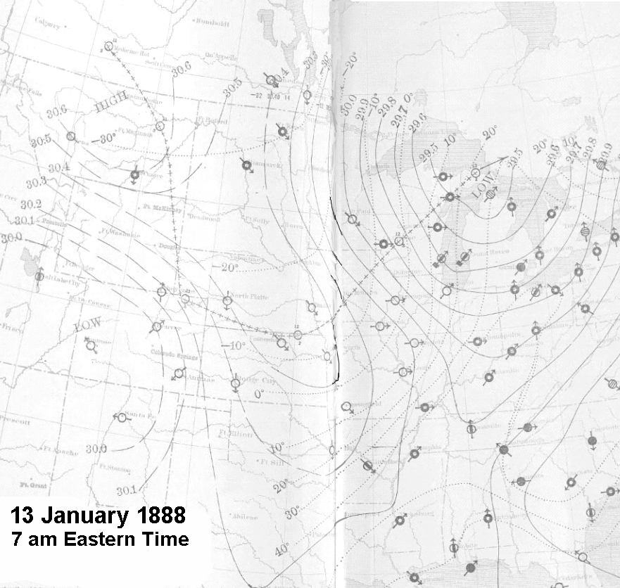
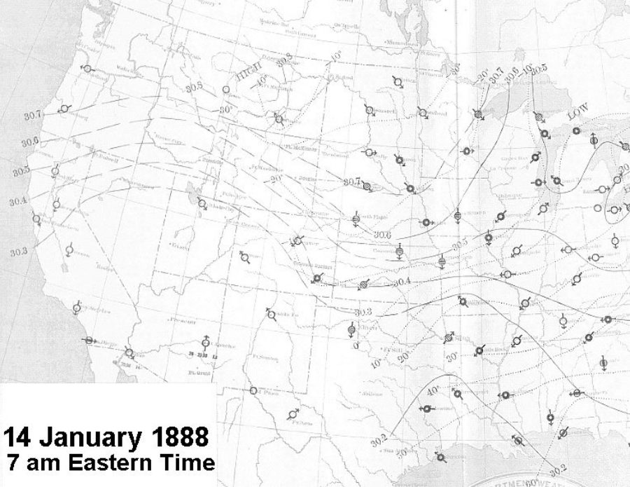
Friday 13 January 1888That Friday morning, many areas saw temperature drops of 20 F degrees (11.1 C degrees) or more from the previous day. In Montana, Helena and Fort Custer registered temperatures below minus 20 oF (minus 28.9 oC), while in Dakota, Bismarck and Fort Totten, the mercury hovered near minus 30 oF (minus 34.4 oC), having dropped more than 30 F degrees (16.7 C degrees) in 24 hours. North Platte and Omaha, Nebraska both lost 44 F degrees (24.4 C degrees) over a day to a bone-chilling minus 16 oF (minus 26.7 oC). In Keokuk, Iowa, the wind shifted at midnight and the temperature fell rapidly on 38 mph (61 km/h) gales. By 8 am, it had fallen 66 F degrees (36.7 C degrees) to minus 13 oF (minus 25 oC). To make matters worse, the low temperatures in Dakota were accompanied by winds reported at 30 mph (50 km/h) or more. This combination resulted in a windchill temperature (using today's equation) of around minus 67 F (minus 55 C), a temperature where frostbite can occur in five minutes. Huron, Dakota fell from 20 oF (minus 6.7 oC) at noon the previous day to minus 28 oF (minus 33.3 oC) during the night as the temperature dropped, the winds howled at an average speed of 45-50 mph (72-80 km/h) with gusts to 60 mph (96 km/h). The high pressure ridge extended from northwest Montana to Oklahoma where temperatures were still above freezing. The minus 20 oF (minus 28.9 oC) isotherm drawn on the daily weather map covered from Montana eastward to western Minnesota and south into northern Nebraska. Saturday 14 January 1888The morning of the 14th, was to be the coldest on record at many observing sites, not terribly surprising on its own, given the short record of data then available in the West (and most of the nation). But many of those records remain the coldest today, over a century later; others remained for decades as the record low temperature.
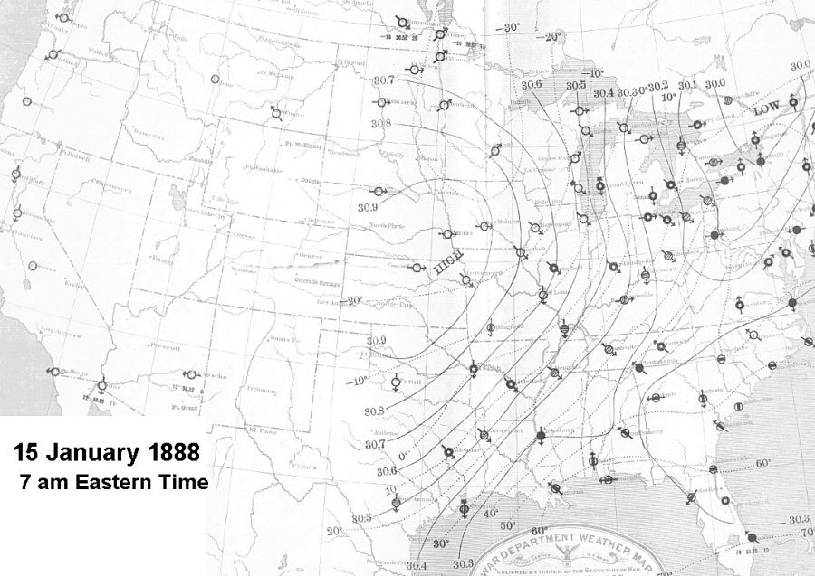
The thermometer bottomed out at Fort Keogh, near Miles City, Montana, at a bone-numbing minus 65 oF (minus 53.9 oC). It was the coldest temperature ever recorded in the contiguous United States and would remain so for 45 years (until a minus 66 oF (minus 54.4 oC) reading in West Yellowstone, Montana in 1933). Most of Montana likely chilled to below minus 40 oF (minus 40 oC), save for Helena's reported minus 36 oF (minus 37.8 oC) at the morning observation. Fort Custer registered minus 42 oF (minus 41.1 oC), an 18 F degree (10 C degrees) dip from the previous day. At 7 am on the 14th, Fort Totten continued to see dropping temperatures, another 8 F degrees (4.4 C degrees) to minus 38 oF (minus 38.9 oC); Bismarck rested at minus 32 oF (minus 35.6 oC) but had recorded a minus 38 7 oF (minus 39.3 oC) low earlier, and Fort Buford sat at minus 28 oF (minus 33.3 oC). Southern Dakota Territory chilled at minus 26 oF (minus 32.2 oC) at both Huron and Fort Sully and minus 20 oF (minus 28.9 oC) at Yankton. Valentine and North Platte, Nebraska chimed in at minus 24 oF (minus 31.1 oC). Across Minnesota, the thermometer dropped to minus 32 oF (minus 35.6 oC) in Moorhead, minus 22 oF (minus 30 oC) in St Paul and minus 30 oF (minus 34.4 oC) at Duluth. La Crosse, Wisconsin reported a low of minus 22 oF (minus 30 oC), a fall of 41 F degrees (22.8 C degrees) in 31 hours. Denver reported a comparatively warm minus 16 oF (minus 26.7 oC) but that was 28 F degrees (15.6 C degrees) lower than the previous day. The local Denver observer notes for the time indicate that the "cold-wave warning flag was not only justified, but was followed by one of the most severe cold waves that ever struck this section." While the coldest air hadn't yet reached many of the cities around the Great Lakes, the front had passed resulting in temperature drops of 20 or more F degrees (11.1 C degrees) in Michigan and Wisconsin. Detroit lead the pack with a 34 F-degree (18.9 C degree) drop; nearby Toledo, Ohio fell 36 F degrees (20 C degrees). Sunday: 15 January 1888Sunday 15 January saw the dome of frigid air nominally centered over Nebraska and Kansas. The Signal Service summary indicates that on this day: "On the morning of the 15th the whole US the United States was covered by this high area, which was dividing into two portions, one remaining still central over Idaho the other central over Kansas. The cold wave had moved to the southeast over the west Gulf states and freezing temperatures were reported from San Antonio, Galveston, Corpus Christi, Rio Grande City, Brownsville, Tex., and Shreveport, La. [Monthly Weather Review, January, 1888]
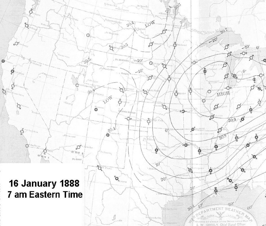
Unfortunately, much of the data from the west, particularly from Montana and Colorado, was missing when the daily weather map was drawn due to late reporting. Based on the available data, the center of the cold sprawled across Minnesota. St Paul reported minus 36 oF (minus 37.8 oC), while nearby Fort Snelling registered minus 43 oF (minus 41.7 oC). In Northfield, at Professor Payne's observatory, the thermometer read minus 37 oF (38.3 oC). Moorhead reported minus 32 oF (minus 35.6 oC), and St Vincent, Minnesota a minus 38 oF (minus 38.9 oC). Across the border in Dakota, Huron reported minus 20 oF (28.9 oC), a warming from the minus 31 oF (minus 35 oC) the previous evening. Yankton had warmed to minus 24 oF (minus 31.1 oC). Bismarck stood at minus 28 oF (minus 33.3 oC). Further south in the Missouri Valley, it was also bone-chillingly cold: minus 25 oF (minus 31.7 oC) at Omaha, minus 26 oF (minus 32.2 oC) at Valentine, minus 28 oF (minus 33.3 oC) at Genoa, and minus 35 oF (minus 37.2 oC) at North Platte, where the barometer read 30.94 inches Hg (1048 mb), the highest station pressure on record there. In Kansas, Leavenworth reported a temperature of minus 20 oF (minus 28.9 oC) with Concordia at minus 24 oF (minus 31.1 oC). Across the western Great Lakes, the cold was deepening. Green Bay, Wisconsin reported minus 22 oF (minus 30 oC), a drop of 10 F degrees (5.6 C degrees). Milwaukee reported minus 16 oF (minus 26.7 oC). Marquette, Michigan and Chicago stood at 14o below zero F (minus 25.6 oC), a 10 F degree (5.6 C degree) drop. In the upper Mississippi Valley, the Iowa capitol of Des Moines shivered at minus 36 oF (minus 37.8 oC) while the cities of Keokuk and Davenport stood at minus 22 oF (minus 30 oC). Springfield, Illinois marked the thermometer at minus 18 oF (minus 27.8 oC) while Springfield, Missouri was at minus 10 oF (minus 23.33 oC). St Louis reported a balmy minus 8 oF (minus 22.2 oC). The zero oF (minus 18 oC) isotherm covered most of Illinois and then descended across northern Arkansas and into central Texas. Fort Smith, Arkansas registered 2 oF (minus 16.7 oC) while Little Rock checked in at 8 oF (minus 13.3 oC). While the cold in the northern states came with light winds, the drop across Texas came on winds blowing at 20 mph (32 km/h) or more. At Fort Elliott, Texas, a "blue norther" rushed across the station at 8 am on the 14th, which was to become the coldest day on record at that site: a mean temperature of minus 7 oF (minus 21.7 oC). The norther continued blowing at around 40 mph (64 km/h) through the 16th when the coldest temperature since the establishment of the station, minus 14 oF (minus 25.6 oC), was recorded. The temperature in Palestine, Texas also plunged as the "blue norther" crossed the region, a whopping 44 F degrees (24.4 C degrees) in 24 hours to the 4 oF (minus 15.6 oC) mark, but San Antonio had them beat with a 46 F degree (25.6 C degree) plunge to 14 oF (minus 10 oC). The freezing isotherm (32 oF (0 oC)) passed out into the Gulf waters along the central Gulf Coast of Louisiana. The cold brought sleet and snow to the central South. The signal flag at the Signal Corps station in Abilene, Texas froze to the flagpole and could not be lowered. Abilene saw the norther come through around 10 am. Twelve hours later, the mercury stood at minus 2 oF (minus 18.9 oC). The next morning the minimum temperature bottomed at a then-record minus 5 oF (minus 20.6 oC). Galveston reported fine drifting snow and freezing mist. Accompanied by 40 mph (64 km/h) winds, the Galveston temperature plunged from 62 oF (16.7 oC) to 29 oF (minus 1.7 oC) in a few hours. The observer noted: "A veritable blizzard is raging in Galveston today." On the south side of the front where temperatures remained warm, New Orleans woke to a 66 oF (18.9 oC) reading, while Shreveport shuddered at 18 oF (minus 7.8 oC), a 28 F degree (15.6 C degree) temperature drop across the front there. Monday 16 January 1888On the morning of the 16th, the whole of the United States was covered by high pressure, which was now dividing into two portions, one still remaining centered over Idaho, the other portion centered over Kansas. The highest pressure being reported along a ridge from Indianapolis, Indiana to Des Moines, Iowa and north to La Crosse and Green Bay, Wisconsin. The air mass continued moving further south and east, and the cold in the north-central third of the United States lessened.
In Corpus Christi, Texas the temperature dropped from 60 oF (15.6 oC) to a low of 16 oF (minus 26.7 oC) with light snow. At Brownsville, at the southern-most tip of the Lone Star State, the temperature plummeted 40 F degrees (22.2 C degrees) in eight hours as freezing rain coated trees and houses and brought down the Western Union telegraph lines. The cold wave, accompanied by snow except along the Gulf Coast where rain fell, advanced during the 15th and 16th over the eastern Gulf states, Tennessee, and the south Atlantic states. By the morning of the 16th Abilene, Texas reported a minimum temperature of minus 6 oF (minus 21.1 oC), the "coldest of which there is any record, and colder than the oldest residents have ever seen it." Mobile, Alabama dropped 32 F degrees (17.8 C degrees) to the freezing mark and New Orleans reported 40 oF (4.4 oC), a 26 F degree (14.4 C degree) plunge from the warmth of the previous day. Oswego, New York plummeted 36 degrees (20 C degrees) and Pittsburg, Pennsylvania sunk 32 degrees (17.8 C degrees). In the northwest, temperatures were generally higher than the previous day, though Helena still checked in at minus 34 oF (minus 36.7 oC) and Fort Custer at minus 32 oF (minus 35.6 oC). Most areas of the upper Mississippi Valley, Missouri Valley and northern Rocky Slopes continued to report below zero oF (minus 18 oC) temperatures. La Crosse, Wisconsin was the cold spot at minus 38 oF (minus 38.9 oC). Last Days and SummaryThe eastern cell of high pressure moved to the southeast, and, with slowly diminishing pressure, began to pass beyond tho coast on the 17th. The continued to slowly drift and left the Georgia coastline on the 20th. In its wake, it caused a minor cold wave in the deep south on the 18th. While the central and southern portions of the nation received most of the attention from this cold wave, the western branch of the original arctic air mass slipped southwestward to the Pacific Coast and into California. The coldest temperatures ever experienced covered Oregon from the 14-16th. Cold temperatures records set at the time included: minus 30 oF (minus 34.4 oC) in Spokane Washington; minus 28 oF (minus 33.3 oC) in Boise, Idaho; minus 24 oF (minus 31.1 oC) in Lakeview, Oregon. All of these readings still stand as the record low for each location. Portland, Oregon fell to minus 2 oF (minus 18.9 oC). In addition, the daily high temperatures of minus 10 oF (minus 23.3 oC) in Spokane and 9 oF (minus 12.8 oC) in Portland still stand as the coldest daily maximum temperature ever recorded in those cities. Ely, Nevada dropped to minus 36 oF (minus 37.8 oC) and Salt Lake City hit minus 17 oF (minus 27.2 oC). "Unusually low temperatures were observed throughout California from the 14th to the 18th, and frost and ice were formed at places where they are of very rare occurrence." [Monthly Weather Review, January 1888]. The temperature fell to 20 oF (minus 6.7 oC) in Eureka (still a record) on the 14th and 29 (minus 1.7 oC) in San Francisco on 15 January, the latter the coldest recorded to that date since records began in 1871. Snow fell on San Francisco on the 16th. Sacramento dropped to 19 oF (minus 7.2 oC) on both the 14th and 15th, the lowest temperature there since a similar value was reached on 21 January 1864. Ice was seen floating down the Sacramento River for the first time since 1864. Further south, both Los Angeles (31 oF (-0.6 oC)) and San Diego reported frost on the 16th and 17th respectively. The conditions across the nation during the month of January were summarized by the US Signal Service report published in the January 1888 issue of Monthly Weather Review thus: "The month may be rated as an unusually cold one over the greater part of the United States, particularly on the Pacific coast, in the plateau region, and in all northern districts, the mean temperatures generally ranging from, 6o to 12o [F / (3.3-6.6 C degrees)] below the normal. "In connection with the temperature of the month, the remarkably cold weather in the northwestern states and territories, attending the prevalence of area of high pressure number iii was an important feature. This extremely cold weather prevailed during the second decade of the month, and some of the minimum temperatures were the lowest recorded since the establishment of Signal Service stations. The minimum temperatures at many stations in the plateau region and on the Pacific coast during the decade mentioned, were similarly without precedent for that region. Seven observing posts saw temperature swings of over 95 F degrees (52.8 C degrees) during the month: Fort Laramie, WY, Poplar River, MT, North Platte NE, Fort Custer MT, Fort Maginnis, MT, Denver CO and Rapid City, SD. Laramie led the swing with a 105.5 F degree (58.6 C degree) differential. Helena, MT had the greatest daily swing 66.5 F degrees (36.9 C degrees) while Poplar River, MT Fort Maginnis, MT, Denver CO and Abilene, Texas also had daily changes of 60 F degrees (33.3 C degrees) or more. Following this cold wave, another cold air mass descended from the north on 18th and covered much of the Missouri and upper Mississippi Valleys by the 20th. It took a more northerly route than its predecessor moving over the Great Lakes before leaving the continent off New Jersey on the 22nd. Though not as widespread as its predecessor, in some areas it was colder than during the previous cold wave. Learn More From These Relevant Books
|
||||||||||||||||||||||||
 |
To Purchase Notecard, |
Now Available! Order Today! | |
 |
 |
NEW! Now Available in the US! |
The BC Weather Book: |