Four years after the great flooding of the Mississippi/Missouri River basins, in 1997, extensive flood waters covered the Red River (know as the Red River of the North in the USA), and Assiniboine River basins in Manitoba and in Minnesota and North Dakota where the Red River forms the boundary between the two states.
The area covered by the Red River floodplain basin, which lies in a glacial lakebed, is so flat that locals say a heavy rain acts like water poured on a tabletop, spreading out to create a shallow lake. Near Winnipeg, the Red River is usually about 150 metres (490 ft) wide, but during flooding, it becomes a lake 65 kilometres (40.6 miles) wide and 100 kilometres (62 miles) long. Because of the flatness of the region, the timing of spring thaw and snowmelt can greatly aggravate flooding in the basin. Thus, the region is very prone to flooding each Spring, but the 1997 flood sits high in the list of extreme flooding events in the basin, some dubbed it the “Flood of the Century.”
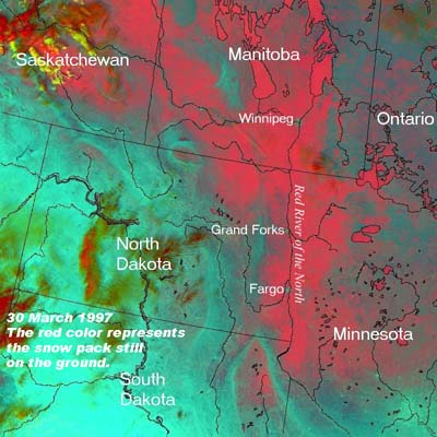
This satellite photo shows the region on 30 March 1997 before the serious flooding began in the Red River Valley. The red color represents the snow pack still on the ground. Courtesy NASA
The underlying cause for the 1997 flood was a record winter snowfall (about 300 percent greater than normal) that in many areas measured more than 100 inches (250 cm) of total accumulation. About 117 inches (298 cm) of snow accumulated in Fargo, 96 inches (244 cm) in Grand Forks, and 101 inches (252 cm) in Bismarck. There was a rapid spring thaw and then another major snowstorm hit on 5-6 April. The blizzard brought a severe drop in temperatures, winds up to 70 miles per hour (112 km/h), and up to 2 feet (60 cm) of snow with drifts many feet higher in several areas. In southeastern North Dakota, the blizzard was preceded by wind-driven rain and sleet. The total precipitation from this storm measured over two inches (50 mm) in western Minnesota, including 3.63 inches (92.2 mm) at Crookston over two days. That accumulation exceeded any two-day precipitation event for either March or April by over an inch (2.5 cm).
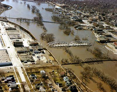
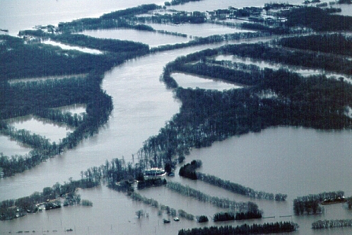
The Red River in flood in Grand Forks, North Dakota and East Grand Forks, Minnesota. Courtesy U.S. Army Corps of Engineers Digital Visual Library
North Dakota/Minnesota
In the Red River Valley of eastern North Dakota and west central Minnesota flooding persisted from early April through mid-May of 1997. In Manitoba, the waters reached flood stage in April and finally receded in early June. Called “The Flood of the Century”, the 1997 flood reached waterlevels that would occur about once in 100 years.
The Red River crested at 39.5 feet (12.0 m), 22.5 feet (6.9 m) above flood stage at Fargo, North Dakota on Thursday, 17April, breaking a 100-year-old record. The crest then surged into Grand Forks, North Dakota, and East Grand Forks, Minnesota, pushing water levels to 54.2 feet (16.5 m) on April 21; where the flood stage is 28 feet (8.5 m). Floodwaters also worried residents of Moorhead, Minnesota, across the state border from Fargo, and at Wahpeton, North Dakota and Breckenridge, Minnesota. In some of these areas, the flooding did not result from rising river levels, but from the inability of the swollen river to drain away the snowpack’s melt waters.
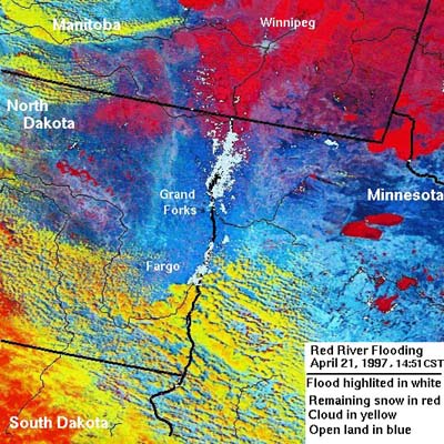
This image was taken shortly after the flood devastated Grand Forks on 21 April 1997. In some places, the river is now 15 miles wide. Courtesy NASA
Grand Forks Mayor Pat Owens issued mandatory evacuation orders on 18 April, and many of the nearly 50,000 people under the order moved to Grand Forks Air Force Base where they slept in airplane hangars containing more than 3,000 cots. Large sections of the city flooded as dikes failed that day. To add insult to injury, a large fire destroyed eleven buildings and sixty apartment units in Grand Forks. Residents of East Grand Forks also were evacuated, taking shelter at the University of Minnesota-Crookston campus.
The waters spread out for over two miles (3 km) from the Red River bank, which caused the evacuation of all of East Grand Forks and 75 percent of Grand Forks. Schools canceled classes in both cities, and they remained closed for the remainder of the term. A similar fate hit classes at the University of North Dakota in Grand Forks. This evacuation, of over 50,000 people, became the largest civil evacuation in the United States since Atlanta, Georgia was evacuated during the Civil War. (The magnitude of the evacuation has since been surpassed.)
It was not until 30 May that the Red River finally fell below flood stage everywhere in South Dakota. When all was tallied, the damage estimate came to $3.5 billion (US), which at the time ranked as the eighth most costly disaster in the US since 1903. Two deaths were attributed to the flood. The floodwaters covered 4.5 million acres (1.8 million hectares) in the two states. The Red Cross estimated that over 5200 local businesses had been adversely affected by the floods. In Grand Forks, 315 businesses, three quarters of the homes, and 16 of 22 local schools had been flooded.
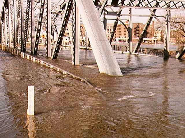
Sorlie Bridge in East Grand Forks, ND on April 17, 1997. Courtesy Army Corps of Engineers
Manitoba
Across the border, the situation was similar. For more than seven weeks, Manitobans battled the floodwaters of the Red River. Forewarned by the situation in North Dakota, the Manitoba government called in the Royal Canadian Mounted Police, 3,000 Canadian Forces soldiers and workers from the Department of Natural Resources to build dikes and lay sandbags. Thousands of local residents pitched in, and in a matter of days, this large workforce constructed sandbag dikes, one of which measured 42 km (26 miles) long. Approximately 8.1 million sandbags were filled, which, if placed end to end, would stretch from Winnipeg to Vancouver.
The Red River during the 1997 flood, viewed southwards from near St. Norbert, Manitoba. Courtesy Geological Survey of Canada
The first mandatory evacuation order is issued on 23 April by Winnipeg Mayor Susan Thompson. In total, 2,320 homes and businesses were evacuated in Winnipeg, representing an estimated 9,000 people. The flood damaged 10,500 homes in Winnipeg, but the toll could have been worse had not the Red River Floodway diverted most of the floodwaters away from the city.
On 26 April, the provincial government advised a high flooding risk was possible if the Burnkild Dike failed. While many of the dikes held, at St Agathe, the flood waters skirted the dikes build on the community’s southside and entered from the west. On 30 April, St Norbert was evacuated. The Red River crested at approximately 7.5 metres (24.5 feet) at the James Avenue Pumping Station in Winnipeg on 1 May.
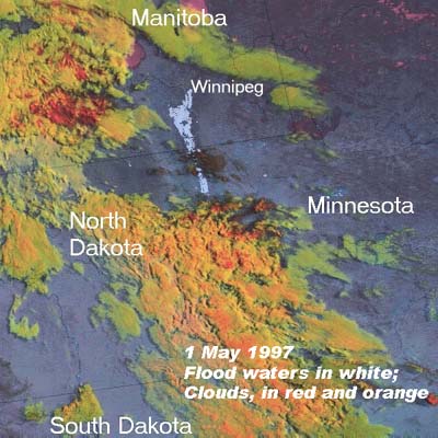
Flood waters on 1 May 1997 have left Grand Forks and Fargo ND, and have entered northern North Dakota and crossed the border into Canada The flood waters have just reached Winnipeg. Courtesy NASA
At the peak flooding, an estimated 1840 square kilometres (710 sq miles) of Manitoba land lay underwater. Locals nicknamed it “The Red Sea.” The communities affected in Manitoba included Emerson, Rosenort, St. Jean Bapiste, Morris, St. Adolphe, Nutimik, Portage la Prairie, Ste. Agathe, St. Norbert, Letellier, Dominion City, Scanterbury, Halstadt, Brunkild, Domain, Sanford and Winnipeg; This flooding resulted in the evacuation of around 26,000 residents.
In Manitoba, flood damages total $815 million in 1997 Canadian dollars and three lives were lost. The floodwaters covered 202,500 hectares (500,000 acres), about five percent, of Manitoba's farmland. Losses to dairy farmers are estimated at $1.3 to $2 million (Can).
I have recently added many of my lifetime collection of photographs and art works to an on-line shop where you can purchase notecards, posters, and greeting cards, etc. of my best images.