| Home | Welcome | What's New | Site Map | Glossary | Weather Doctor Amazon Store | Book Store | Accolades | Email Us |
 | |||||||||
What Causes Lake-Effect Snow SquallsLake-generated snow squalls form when cold air, passing for long distances over the relatively warm waters of a large lake, picks up moisture and heat and is then forced to drop the moisture in the form of snow upon reaching the downwind shore. Lake-effect snows are common over the Great Lakes region because these large bodies of water can hold their summer heat well into the winter, rarely freeze over and provide the long fetch which allows the air to gain the heat and moisture required to fuel the snow squalls. Lake-effect snows are most pronounced and effective wherever terrain features such as small hills or mountains are oriented along the lee shores. Each year as the warm weather of early autumn fades and the first cold blasts of winter rage, the waters of the Great Lakes become increasingly warmer relative to the cold air masses formed in the north. When cold and relatively dry air traverses the lake, the lower levels are warmed and moistened. This air now becomes lighter than the air above it, a condition known to meteorologists as convective instability, and starts to rise. Depending on the degree of instability of the air mass (i.e., how much warmer the lake water is than the air), bands of either stratus, stratocumulus, or heavy cumulus clouds will form over the water, advancing with the wind toward the downwind shore. 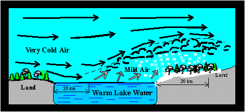 The upward motion of air increases further along the lee shore where the land surface slows down the onshore flow, creating a piling up or convergence of air. The air, having no place else to go, rises rapidly, triggering the formation of snow showers or squalls. Sloping terrain along the shoreline also enhances vertical motions. If snow showers have not begun to fall over the lake, they soon fall as the air rises over the shoreline. The intensity of the lake-effect snowfall depends upon several factors: the temperature contrast between the lake surface and the air passing over it, the over-water distance the air has traversed (the fetch), and the regional weather situation. The distance these storms travel inland increases under higher wind speeds, while their direction is controlled by the winds flowing above the surface. A snow squall's maximum penetration inland will generally be greatest during late autumn/early winter and shortest during the late winter. Most often, lake-effect snowfalls take the form of light to moderate flurries spread over a broad but still limited area. However, an individual squall of heavy snow may remain over one small area for several hours and then, with a shift in the wind direction, move to drop its snow on another area. Satellites and radar observations show that lake-effect snow clouds most often occur in bands resembling streamers. These bands usually form over the lake and are swept inland by the winds. In the Great Lakes, small multiple bands appear to develop when the wind blows across the shorter dimensions of the lake. However, if the wind blows across the length of the lake, a single large cloud band as wide as 80 kilometres (50 miles) and 40 to 160 km (25 to 100 miles) long may form. Such intense cloud bands cause highly localized "blizzards" with swirling, blowing snow reducing visibility to zero. Lake-effect snow cloud bands are remarkably persistent. They have been observed to cause continuous snowfall for as long as 48 hours over a sharply defined region. One single intense local storm cell can yield as much as 120 cm (48 in) of light-density snow in 24 hours or less. As a result, winter weather in the lee of the Great Lakes shows a complex variability of snowfalls, with areas of deep snowfall are often adjacent to areas with relatively little snow.
Learn More From These Relevant Books
|
|||||||||
 |
To Purchase Notecard, |
Now Available! Order Today! | |
 |
 |
NEW! Now Available in the US! |
The BC Weather Book: |


