| Home | Welcome | What's New | Site Map | Glossary | Weather Doctor Amazon Store | Book Store | Accolades | Email Us |
 | |||||||||
It's Coldest After DawnBefore looking into this adage, we must first set some parameters for the discussion. I am talking here of a clear night with no air mass changes during the period to confuse the discussion. (Of course, a cold front passing hours after dawn can produce a temperature less than the morning low at a later hour.) We start the clear night period at sunset which totally cuts off all direct solar heating. Unless we have an air mass change during the night (which can bring warmer or colder air), the surface layer of the earth radiates some of its energy away, and the air in the lowest atmosphere cools. All objects, including you and me, radiate heat away at a rate proportional to their temperature (actually the fourth power) and receive energy back from every object radiating in their view. When more radiant energy is gained than lost, the object generally warms. When more energy is lost than gained, the object cools. When there is a balance between gain and loss, the object can maintain a constant temperature. 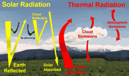 During most of the day, the incoming solar energy is stronger than the outgoing heat radiation (called terrestrial radiation when referring to the Earth system) and the planet's surface warms. (See "Laying Some Groundwork: Balancing Radiation" for more details on the earth's radiation balance.) Between sunset and rise on a clear night, however, the Earth's surface receives no solar heat but continues to lose its heat and thus cools. Clouds and high humidity can retard that heat loss by absorbing the outgoing radiation and redirecting some back to the surface. (That is why I specified a clear night.) 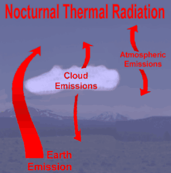 The surface radiation budget is the meteorologist's way of keeping track of how much radiant heat is gained or lost at the surface which helps determine the air temperatures including the maximum and minimum. The full surface radiation budget equation can become very complicated, but the added details expand on a very simple equation that looks very much like a bank or personal financial balance: Financial Statement: Surface Radiation Balance: Savings in the financial statement increases when Deposits exceed Withdrawals and decrease when Withdrawals are greater. Similarly, Storage in the above surface radiation balance equation determines whether the surface warms or cools and thus provides a measure of the temperature of the surface and the air near it. When more heat is gained than lost, there is warming. When more heat is lost, there is cooling. Here is a graph of an idealized daily surface radiation balance with the daytime solar radiation curve also plotted. Solar radiation begins flowing after dawn and ends shortly before sunset, reaching a maximum at solar noon (still assuming clear skies). The strength of that incoming solar radiation depends greatly on the solar season, which defines the sun's angle above the horizon, here the data are plotted for the Equinox at 45o N latitude in the Northern Hemisphere. 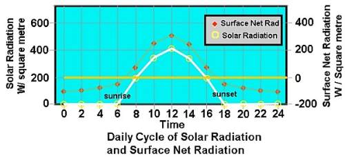 Looking more deeply at the surface radiation balance curve, we can see that it is negative during the night hours indicating the surface is losing radiation and therefore cooling. In the late morning and afternoon, the curve is strongly positive indicating more incoming radiation than heat loss and thus the warming of the surface and its air. (Note this may not be the case in deep solar winter and at high latitudes when the sun's low midafternoon angle cannot overcome the surface heat loss at all during the day.) 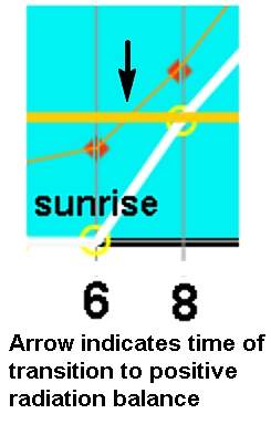 Somewhere during the early morning period, the radiation balance curve crosses the zero line (indicating a balance of gain and loss and therefore no temperature change) from negative to positive. Here is where the switch is made from nocturnal cooling to daytime heating. And what do we notice about this time (I have blown up this region below)? The time of switching does not correspond with dawn but begins an hour or so later. The reason the switch is not coincident with dawn is that during the first hour or so, the incoming solar energy does not yet have enough strength to reverse the heat loss from terrestrial radiation. (A similar condition arises later when solar energy becomes too weak to balance the heat loss in the hours before sunset.) As a result, the surface and lower atmosphere air are still losing heat for some time following sunrise and thus the coldest temperature of the day has yet to be reached. A general rule of thumb puts the time of coldest temperature about an hour after sunrise. Such knowledge has practical applications. If you head out just at or before dawn, prepare for a slightly colder experience for a couple hours. You might even see radiation fog, which can be a driving hazard, suddenly form out of a clear sky if the air temperature drops below the dew point. Learn More From These Relevant Books
|
|||||||||
 |
To Purchase Notecard, |
Now Available! Order Today! | |
 |
 |
NEW! Now Available in the US! |
The BC Weather Book: |


