| Home | Welcome | What's New | Site Map | Glossary | Weather Doctor Amazon Store | Book Store | Accolades | Email Us |
 | |||||||||
Arctic OutbreaksArctic Outbreaks. They happen in all months of the year and can rate headlines during spring, summer, or early autumn if they bring extreme drops in temperature or killing frost. But it is during the winter that they receive the most attention because arctic outbreaks can drop air temperatures to hazardous levels, increase demands for home heating fuels, produce lake/sea effect snows, or in their deepest southern penetration kill sensitive fruit and vegetable crops in the southern American states. As we reach mid-winter, with the polar night having been well established for many months over the northern land masses within the Arctic Circle — Alaska, northern Canada, eastern Russia and Siberia — the continually-building cold almost defies description. Its depth can be best expressed by the Winnipeg, Manitoba settler who wrote in his diary one cold winter night in 1879: "Upon retiring for the night, I tried to blow out the candle, but the flame was frozen, so I had to break it off." Meteorologists classify the frigid Northern Hemisphere air masses as Arctic when they are born north of the Arctic Circle and Continental Polar when they form in the subpolar Canadian North and Alaska. Both are typified by extremely cold temperatures and very little moisture with the Arctic flavour being of the super-sized variety. 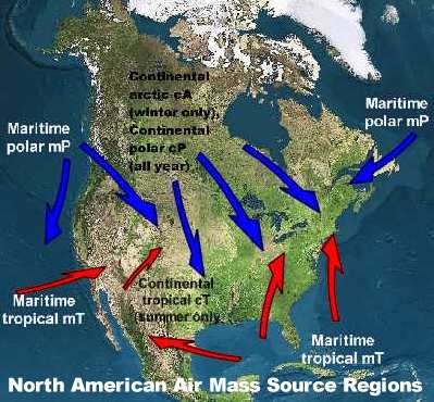
Northern latitudes are the breeding grounds for Arctic and Continental Polar air masses.In the birth grounds of these air masses, the long, dark winter nights couple with clear skies and surfaces covered with snow and ice to continually chill the air. Since in these regions the sun does not rise, or only skirts the horizon for much of January, no warming heat from the sun alleviates the cold. The surface snow and ice reflect away most of what little sun weakly beams down. To accentuate the lack of incoming heat, snow very effectively radiates away what little heat it has, thus dropping surface air temperatures until they reach the temperature of the high atmosphere. The air masses build for some time in these frigid cradles, and the more time they spend in their deep-freeze birthing grounds, the cold and drier they become, chilling the air to bitter temperatures, often less than minus 40°C/F. As a result of that extreme cold, arctic air masses have an extremely low water vapour content (absolute humidity). The low water vapour content further permits the loss of heat from the surface and the air above it because water vapour is a very effective greenhouse gas. The lower the water content, the more radiative heat is lost directly to space. Eventually high-altitude winds catch the air masses and push them outward, usually toward the south and east as huge High pressure systems. Because of their great cold, these air within these masses is very dense and thus pushes surface pressures to 103.0 kPa (1030 mb/30.38 inches Hg) and higher. Each winter much of central and eastern North America typically receives several great blasts of cold arctic air. They chill us to the bone and often produce ground blizzard and extreme wind chill conditions in addition to the frigidly cold temperatures. If the frigid air passes over warmer waters of large lakes and seas, lake-effect and sea-effect snow can accumulate significant snowfalls on the lee shores. Outbreaks of frigid polar air over North America go by many names including: the Norther, the Blue Norther, the Barber, and the Siberian Pipeline. North America stands unique among the northern continents because its major mountain chains run north–south rather than east–west as they do in Europe and Asia. Without north–south mountain barriers to block them, frigid Arctic outbreaks sweep southward unabated across the American interior toward the Gulf of Mexico — and called the El Norte. The great western Cordilleran spine of mountains, particularly the Rockies, that split eastern and western North America inhibits the cold outbreaks toward the Pacific Coast, but it does not eliminate them completely. When such outbreaks push their way through the many mountain chains of British Columbia and southern Alaska, the cold flow is termed an arctic outflow or one of the colourful names such as the Squamish. 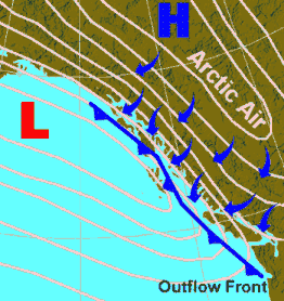 Arctic Outflow along Pacific CoastExtreme Winter Sudden Change DaysWhen the cold front associated with a winter low-pressure system ushers in the blast of cold air of an arctic outbreak, the local air temperature can drop precipitously in a few hours. There are many recorded instances of extreme temperature drops, but here are a few to chill your bones. Browning, Montana: In 24 hours over January 23 to 24, 1916, the temperature dropped 100 Fahrenheit degrees (55.6 Celsius degrees) from 44°F (6.7°C) above zero to minus 56°F (-48.9°C) .Oklahoma City, Oklahoma: A classic Blue Norther hit Oklahoma on November 11, 1911 (11/11/11!!). In a few hours time, temperatures plunged from a balmy, and record, high of 83°F (28°C), to a record low of 17°F (-8°C). By the next morning the temperature fell to 14°F (-10°C) — a drop of 69 Fahrenheit degrees (38.3 Celsius degrees) in less than 24 hours. This event is the only date left in the Oklahoma City record books on which the existing record high and record low temperatures for the date occurred on the same day. At Rapid City, South Dakota the morning of 10 January 1911 saw the temperature drop from 55°F at 7 am to 8°F at 7:15 am — a 47 F deg temperature drop in 15 minutes. Two days later (12 January), the scene was repeated when the temperature fell 62 F deg from 49°F at 6 am. to -13°F at 8 am. On the same day, the temperature in Chicago, Illinois plummeted 62 F deg. Central Illinois: On December 20, 1836, an arctic outbreak struck Illinois that would go down in the memories of many Illinois residents as The Sudden Change Day, Cold Tuesday and The Cold Day in Illinois. At 2 pm, the thermometer in Augusta had recorded a drop from 40°F (4.4°C) to 0°F (-18°C) in less than 8 hours. Not quite as deep a fall as the previous events, but the impact on the population of Illinois was memorable. (For a more detailed account, see my story Illinois' Sudden Change of 1836.) Learn More From These Relevant Books
|
|||||||||
 |
To Purchase Notecard, |
Now Available! Order Today! | |
 |
 |
NEW! Now Available in the US! |
The BC Weather Book: |


