Weather Almanac
for October 1999
TWO FLAGS FLYING

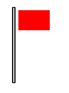
 All along the Atlantic Coast, ports and marinas are flying two identical flags, one above the other. They are square red flags with a black-square centre. At night, three vertical lights, two red with a white one between replaces the flags. These signals, flags by day and lights by night, visually cry out a hurricane warning to all within view.
In these days of global electronic communications where weather forecasts and warnings can be spread nearly instantaneously, many have forgotten how storm warnings were spread prior to the advent of radio. This month, I present a brief history of the early distribution methods for weather warnings and forecasts in North America.
The first weather warnings were likely spread by word of mouth within and among the villages of the peoples of the First Nations. Such warnings and forecasts often came from tribal shamans, men and women who were able to link a variety of natural signs to the onset of changing, and perhaps threatening, weather conditions. But warnings were quite local and could spread no faster than the swiftest runners or canoe paddlers.
The early colonization of North America by Europeans widened the coverage of warning as roads between settlements allowed messages to travel by horseback and ports allowed them to travel by sailing ships. Church and village bells and cannons may also have served to broadcast warnings to townsfolk and farmers working in the fields.
Lighthouses sent out weather warnings at times, but most often they only marked port entrances or warned of rocks and shoals, marine hazards other than the weather. The first lighthouse in the Americas was built in the late 16th century in Vera Cruz, Mexico. The first in the United States was constructed in Boston Harbor in 1716. The first Canadian lighthouse rose over Cape Breton, Nova Scotia in 1733. Unfortunately these early lights were generally weak and were not very effective penetrating fog a and their fires blew out during storms.
The Boston lighthouse was supplemented with a cannon to serve as a fog signal in 1719, booming over the harbor every half hour. But ironically, it was another weather element -- lightning -- that finally destroyed the lighthouse. (In 1775, Colonial militia burned the tower to prevent its use by the British.)
Crude noise-making helped many a fog-bound ship navigate toward port. Wives of local fishermen were known to bang on pots and pans or whistle into the fog to assist offshore fishing vessels in sailing safely homeward. Fog bells were introduced in the US around 1820. Initially they were manually struck by the lighthouse keeper, but mechanical bells eventually replaced hand-rung ones. Beginning in the 1850s, the first fog sirens or horns were introduced using steam boilers to sound the alarm.
The additions of weather warning signals to various lighthouses along the Atlantic Coast proliferated during the nineteenth and early twentieth centuries and expanded to the west coast. The first fog cannon on the Pacific Coast was installed in 1854 at the Point Bonita lighthouse at the entrance to San Francisco's Golden Gate.
The advent of the electric telegraph and the expansion of the railroads fueled the first blossoming of weather forecasts and warnings. Messages could now be sent at a speed unmatched by horse or sailing ship. And the telegraph allowed rapid two-way communication; thus observations could be sent to a central analysis and forecast office.
The first "official" weather forecast to be issued in the United States came on 8 November 1870: a storm warning issued by Professor Increase A. Lapham out of Chicago to observers around the Great Lakes. It read:
"High winds all day yesterday at Cheyenne and Omaha; a very high wind this morning at Omaha; barometer falling, with high winds at Chicago and Milwaukee today; barometer falling and thermometer rising at Chicago, Detroit, Toledo, Cleveland, Buffalo and Rochester; high winds probable along the Lakes."
Meanwhile in Washington DC, Professor Cleveland Abbe began preparing 24-hour forecasts, called "Probabilities" at the time. On 19 February 1871, he issued the first public weather forecast in the United States from observations taken at 7:35 AM. It read:
"Probabilities; it is probable that the low pressure in Missouri will make itself felt decidedly tomorrow with northerly winds and clouds on the lakes, and brisk southerly winds on the Gulf."
By the end of the year, the forecast regions began to spread westward. The forecasts were initially sent from Washington to local weather stations around the country and railroad stations where they were posted on public message boards. Copies were also sent to the Associated Press for use in daily newspapers. By 1873, thousands of US Post Offices displayed the forecast for public viewing.
The system was fraught with inefficiencies, however. For example, one local telegraph operator kept an important forecast message at his office and did not relay it further as required. Thus, the correct forecast of an impending killer frost did not read Madison, Wisconsin tobacco farmers. Thirty-six hours later, nighttime frost destroyed the ready-to-harvest crop before it could be cut.
 In additions to getting the forecasts and warnings out from the forecast headquarters to regional offices, there was a need to spread the forecast, and especially weather warnings, out from the telegraph offices to the public to arrive in time to be of use. By 1878, two official flags had been adopted by the US Signal Service to "broadcast" two specific weather warnings: a high-wind warning flag and a cold-wave warning flag. Each measured 6 by 8 feet and were visible for great distances. In additions to getting the forecasts and warnings out from the forecast headquarters to regional offices, there was a need to spread the forecast, and especially weather warnings, out from the telegraph offices to the public to arrive in time to be of use. By 1878, two official flags had been adopted by the US Signal Service to "broadcast" two specific weather warnings: a high-wind warning flag and a cold-wave warning flag. Each measured 6 by 8 feet and were visible for great distances. 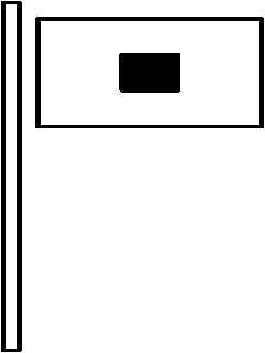 The high-wind warning flag, a plain red flag, indicated winds were expected to exceed 25 mph.The first flew on 26 October 1871. The cold-wave warning flag was white with a 2-foot square black centre. By the end of 1886, these flags were available at 290 cities and towns. By 1891, official weather warning flags could be flown at The high-wind warning flag, a plain red flag, indicated winds were expected to exceed 25 mph.The first flew on 26 October 1871. The cold-wave warning flag was white with a 2-foot square black centre. By the end of 1886, these flags were available at 290 cities and towns. By 1891, official weather warning flags could be flown at
over 1200 locations across the US.
Forecast information was also broadcast across a region by local authorities using a variety of other signal flags. Flag patterns and colors varied across the country. For example, in the South two coloured flags were used.
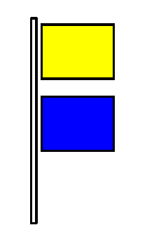 | 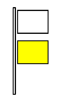 |
| For local rains and steady temperatures, a yellow flag perched above a blue flag. | For fair weather and warmer temperatures, a white flag flew above a yellow one. |
| In Pennsylvania and Ohio, white weather flags sported a coloured symbol with red colouring indicating temperature tendency and blue, the weather condition. On them a star, sun, or crescent indicated tendency. For temperature, a red sun forecast higher temperatures; the crescent moon, lower temperatures, and the star, steady temperatures. A blue sun on the flag | 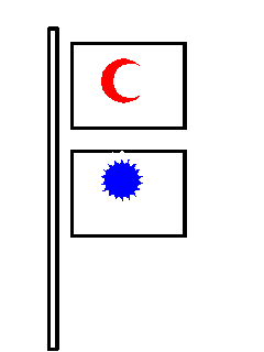 |
| indicated general rain or snow; a blue crescent, clear or fair weather, and a blue star, localized rain or snow. Similar flags were used in New England with coloured numbers instead of symbols used to indicate weather conditions. | Flag used in
Pennsylvania and Ohio
indicating:
Lower Temperatures
and
General Rain/Snow |
In Canada, the first storm warnings were posted at 35 storm warning stations in eastern Canada based on the forecasts received from the US Signal Service beginning in 1874.Fifty-six times that year, storm warnings were dispatched to the proper station.
On 10 October 1876, the first Canadian public forecasts for Ontario were issued from Toronto. By 1879, the daily probabilities were telegraphed to 125 places from Ontario eastward to Prince Edward Island at 10 a.m. daily. Local recipients were expected to post them on a public bulletin board outside the local telegraph office, post office, railway station or school. Newspapers also received forecasts for publication in the evening editions.
To relay forecast information directly to farming communities along the rail lines between Windsor, Ontario and Halifax, Nova Scotia, an interesting system was employed beginning in 1884. Railway agents would receive the morning forecasts via telegraph and then affix large metal discs to either the locomotive or baggage cars of outbound trains. The pattern on the disc would inform farmers working in fields along the tracks of the expected weather conditions: a full moon meant sunny skies; a crescent moon, showers; a star, prolonged rains. Unfortunately, local rail workers too often neglected to update the discs, and within a decade of its inception, the system was dropped.
At 35 Canadian ports and harbours along the Great Lakes, St. Lawrence River and Atlantic Coast, wind warnings were posted using wicker baskets, cones or drums hoisted up a mast or pole. The type of object indicating the approach of a storm and its expected strength, an improvement over the then-current American practice of only indicating that winds would be strong. Later, lanterns were also used to send the warnings by night. The wicker basket and signal drums reportedly flew until the 1950s when the last storm station was decommissioned.
On November 1, 1898, the first weather forecast on the West Coast appeared in the Victoria newspaper, the Daily Colonist. Marine weather warnings began the following March. When thirty-six hour forecasts for the expected wind conditions were received by the harbourmasters along the coast, the corresponding signal was raised.
With the formation of the US Weather Bureau in 1891, the number of flags to indicate changing weather conditions was further expanded. These included:
| Flag Type | Weather Expected |
| White Flag: | Clear or fair weather. |
| Blue Flag: | Rain or snow. |
| White over Blue Flag: | Local rains. |
White Flag with Black
Square in Center: | Cold wave. |
| Red Flag: | High winds. |
These flags were especially designed for the display of information to the general public where they will benefit agricultural and commercial interests. The flags were displayed upon railroad trains, river steamers, at railroad stations and at other locations having telegraphic communication.
Forecasts were also distributed by the post office using postal cards stamped with key phrases, such as "fair and colder" and "warmer with showers". In some areas, other signals were also employed. In areas of Massachusetts, electric search lights were used. Whistles, fire alarms and rockets and aerial bombs were introduced in some locals to warn of impending weather. Storm warnings by chain telegraph or telephone were also tried with minimal success.
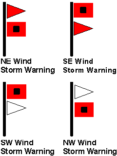
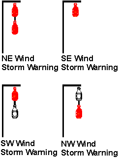
The United States replaced its single marine warning flag with a pennant and flag combination and a lantern arrangement at night to indicate the direction from which the storm winds would blow.
| Warning Type | Warning Flags | Warning Lanterns |
| NE Wind Storm Warning: | Red pennant above square red flag with black center. | Two red lanterns, one above the other. |
| SE Wind Storm Warning: | Red pennant below square red flag with black center. | One red lantern. |
| SW Wind Storm Warning: | White pennant below square red flag with black center. | White lantern below red lantern. |
| NW Wind Storm Warning: | White pennant above square red flag with black center. | White lantern above red lantern. |
| Hurricane Warning: | Two square red flags with black center, one above the other. | Two red lanterns with a white lantern between. |
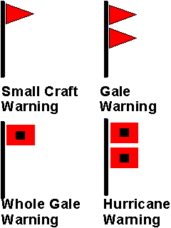
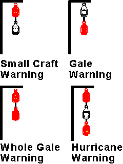
In 1912, a single red pennant was introduced to indicate moderate to strong winds, a warning to small watercraft.
Another method of forecast dissemination in urban areas was via the street car. According to the US Weather Bureau in 1901, weather forecasts were relayed to the public by posting them in a prominent position in street cars. Reportedly the practice met with great favour wherever it was practiced.
In 1958, the US replaced that system with pennant/flag and light signals that indicated the strength of the impending wind condition rather than the wind's direction:
| Warning Type | Warning Flags | Warning Lights |
| Small Craft Warning: | Single red pennant. | Red light over white light. |
| Gale Warning: | Two red pennants. | White light over red light. |
| Whole Gale Warning: | Single square red flag with black center. | Two red lights. |
| Hurricane Warning: | Two square red flags with black center, one above the other. | Two red lights with a white light between. |
Slow communication of weather forecasts and warnings continued to plague the weather services in the United States and Canada until the advent of wireless communications. With radio broadcasts, weather information could be made available to nearly everyone very quickly. Beginning in 1920, ships at sea could receive regular forecasts and warnings as well as send weather and storm observations back to land. A new era of weather warnings had begun, one which continues to grow today via television, radio, internet linkages, cellular phones, and soon, direct wireless links to all manner of computer hardware.
But despite these technical advances, sirens still wail tornado warnings across Tornado Alley, and weather warning flags still fly over coastal waters. Two flags are flying; Hurricane Irene is coming to town.
Learn More About Hurricanes and Storm Winds From These Relevant Books
Chosen by The Weather Doctor
- Sheets, Bob and Jack Williams: Hurricane Watch : Forecasting the Deadliest Storms on Earth, 2001, Vintage Books; ISBN: 037570390X.
- Zebrowski, Ernest Jr and Judith A. Howard: Category 5: The Story of Camille — Lessons Unlearned from America's Most Violent Hurricane, 2005, ISBN 0472115251, Hardcover, 304 pages.
- Deblieu, Jan: Wind : How the Flow of Air has Shaped Life, Myth, and the Land, 1998, Houghton Mifflin Company, ISBN 0-395-78033-0.
Written by
Keith C. Heidorn, PhD, THE WEATHER DOCTOR,
October 1, 1999
The Weather Doctor's Weather Almanac Two Flags Flying
©1999, Keith C. Heidorn, PhD. All Rights Reserved.
Correspondence may be sent via email to: see@islandnet.com.
For More Weather Doctor articles, go to our Site Map.
I have recently added many of my lifetime collection of photographs and art works to an on-line shop where you can purchase notecards, posters, and greeting cards, etc. of my best images.
Home |
Welcome |
What's New |
Site Map |
Glossary |
Weather Doctor Amazon Store |
Book Store |
Accolades |
Email Us
|


|