The 2013 Atlantic Hurricane Season has started slowly. The first hurricane formed just hours prior to the mark for the latest first hurricane in the modern, satellite era. The Atlantic basin generally gets all the focus as the US coastline and inland regions is home to millions of Americans. Less focus falls on the Eastern Pacific hurricane region, whose season begins a fortnight prior to the Atlantic's and is active until 1 December. Almost all of these storms form off the western Mexico coast and the majority head out into the Pacific. But with the dearth of storms in the Atlantic basin, attention shifted in later September 2013 to the Pacific as Hurricane Manuel, coupled with Atlantic Hurricane Ingrid, to bring death and destruction to Mexico.
In contrast, for the 2013 season to date (mid-September), six storms of the 13 named have become hurricanes. Three of those moved out over the open ocean, one moved parallel to the Mexican coast before weakening and one moved northward and crossed Mexico's Isthmus of Tehauntepec toward the Gulf of Mexico, however, it lost energy in the crossing and entered the Gulf as a tropical depression. The last and latest so far, Manuel did much damage to Acapulco as a rain-laden tropical storm days prior to it gaining hurricane status. The double blow from Manuel and Ingrid marked the first time since 1958 that two tropical storms had struck both Mexican coasts within 24 hours.
For the US West Coast, the direct wind impact of tropical storms is rare, and what impacts do occur usually come as heavy rains to the area. A few East Pacific storms can live long enough to worry the Hawaiian Islands. Thirty nine have hit the Hawaiian Islands since 1950. The most deadly (6 deaths) being Iniki in 1992. (A full discussion of East Pacific tropical storms can be found here.)
The historic tropical storm record for Southern California is not extensive. And the most recent entry to that list actually occurred over a century and a half ago when a search for weather events in the early history of American California by Michael Chenoweth found mention of a strong storm hitting the San Diego area in 1858. Further analysis of this storm by Chenoweth and meteorologist Christopher Landsea determined that the storm likely hit the community as a hurricane, thus making it the strongest tropical storm to hit southern California in the historical record.
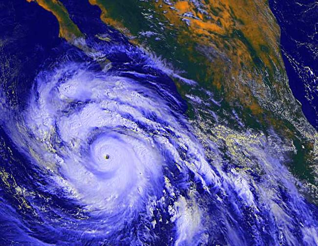
Hurricane Linda Moves Up Toward Baja California Image Credit: NASA/NOAA
Tropical Storms in Southern California
The historic tropical storm record for Southern California is short, particularly when compared to some eastern US locations: 62 from the earliest records to 2009. Most of these impacted the region with heavy rainfall associated with a storm or it remnants rather than high winds. Only 4 of these storms brought winds of gale force or higher to the coast: 1858, 1939, 1976 (Kathleen), 1997 (Linda). (In 1997 on the heels of Linda, Hurricane Nora crossed Baja California as a tropical storm and entered the US in the southeastern California/Arizona region as a tropical storm.) Other than the 1858 storm, the only tropical storm to directly strike the southern California coast was the 1939 storm. The others moved across Mexico first.
[By comparison, Savannah, Georgia, at about the same latitude on the US Atlantic Coast has been struck by 91 storms with tropical storm winds or higher in the past 141 years of which 21 were hurricanes.]
There are two main reasons that tropical storms do not directly strike the Southern California area (though remnants may bring rainfall to the region). The first is the sea surface temperature. Tropical cyclones require warm ocean waters from which to pull energy to sustain the storm winds. Generally, these waters should be above 26.5��C (80��F) and extend to a depth of 50�metres (160�ft). Even during its warmest period in late summer, the waters off southern California usually remain well below that threshold. The climate record shows they rarely rise above 24��C (75��F) near shore and generally don't exceed 17��C (63��F). The waters of the cold California Current that runs southward down the coast are further chilled as they pass by the upwelling of cold waters from depth in the coastal waters off the State and southward along the Baja California coast.
The second factor is the overriding upper-air atmospheric circulation in the subtropical east Pacific that flows seaward to the west and northwest off the coast. This flow steers most tropical storms forming off the western North American coast out to sea. Closer to shore, the wind field generally has a strong vertical shear as it flows off the coast, which is also damaging to tropical storms.
The San Diego Hurricane of 1858
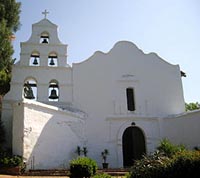
San Diego has a long history. The Presidio and Mission of San Diego was founded in 1769, the first European settlement in what is now California. Following the Mexican-American War of 1846�1848, the territory of Alta California, which included San Diego, was ceded to the United States by Mexico. In 1850, California became the 31st state in the United States of America. The village of 500, was incorporated as a city that year and the seat of the newly established San Diego County. The census of 1860 showed the population had increased to 731, and further blossomed in the succeeding decades.
[The discussion of the storm relies heavily on the work of Michael Chenoweth, Independent Scholar, Elkridge, Maryland, USA and Chris Landsea of NOAA/Hurricane Research Division Miami, Florida, entitled �The San Diego Hurricane of 2 October 1858� and published in the Bulletin of the American Meteorological Society, November 2004. Much of the storm description gleaned by Chenoweth comes from the local papers of the day: mostly the Daily Alta California that carried press items from other newspapers, including the San Diego Herald.]
In the last days of September, a storm formed in the Eastern Pacific basin. It moved in the unusual direction of north northeast and then turned northwestward just off the San Diego coast. As a result, it delivered a glancing blow to the southern California coast on 2 October. It then moved seaward toward the Santa Catalina Islands between San Diego and Los Angeles later that day.
About midday, the storm struck San Diego. According to reports from the Daily Alta California:
"About 11 o�clock A.M. of Saturday, 2d instant, a terrific gale sprung up from the S.S.E. and continued with perfect fury until about 5 P.M., when it somewhat abated, and rain commenced to fall. It blew with such violence, and the air was filled with such dense clouds of dust, that it was impossible to see across the Plaza, and it was with the greatest difficulty that pedestrians could walk the streets. The damage to property was considerable; houses were unroofed and blown down, trees uprooted, and fences destroyed. It is said to have been the severest gale ever witnessed in San Diego.
"So fearful was the gale at Point Loma, the Lighthouse Keeper, Capt. Keating, was obliged to leave at 12 o�clock, P. M., fearing the tower would fall. No damage, however, was done. The roof of the house of Don Mattias Moreno was blown off, and carried some distance into a neighboring corral, but fortunately no damage was done to the inmates or the furniture of the house.
"The windmill, recently constructed by Mr. Geo. P. Tolman, on Mission Point, was almost entirely demolished, nothing remaining but the shaft and one of the fans. Mr. Tolman�s loss is considerable. The house of Andrew Kriss, on the flat, was completely destroyed. Great damage was also done to the fences and walls of different enclosures in town.
"According to local observations by townsfolk, the storm approached with weather conditions �ominous, and portended a sudden change of some extraordinary character; about 7 1-2 o�clock, A.M., we had a slight shower of rain with the wind from S.S.E.� The keeper of the tide gauge noted �the barometer went almost immediately down several degrees lower than has ever been known in this vicinity."
At this time, �several very heavy gusts of wind came driving madly along, completely filling the whole atmosphere with thick and impenetrable clouds of dust and sand. ... the violence of the wind still increasing, until about one o�clock, when it came along in a perfect hurricane, tearing down houses and everything that was in its way.� Three schooners, the Plutus, the Lovely Flora, and the X.L. were cast upon the shore
�From this time until dark a continuance of the above was experienced, interspersed now and then by a crash of some house, tree, fence, or something of the kind; with the sun the wind went down; during the night we had a considerable fall of rain, which made a very pleasant change.�
The cold waters offshore and shearing winds quickly took their toll, and the storm likely dissipated sometime during the night of 2/3 October.
The now-dying storm moved on past the port of San Pedro, south of Los Angeles. �The wharf at San Pedro was very much injured, a large part of the flooring having been carried away by the violence of the sea,� according to the Los Angeles Star. �Mr. Banning�s famous yacht �Medora� suffered from the envious winds and waves.� The winds �rose in their might against her, drove her from her moorings on to the beach, where they prevailed against her and broke her up, scattering her fragments on the shore.�
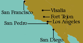
Estimates of rainfall during the course of the storm have been pegged as high as 7 inches (175 mm). The report in the Daily Alta California said: �The quantity of water which fell was unusually great, being estimated by those who had opportunities of judging pretty correctly, at seven inches.� Heavy rainfall was also reported in surrounding communities of San Pedro, Los Angeles, Fort Tejon and Visalia.
The best, and only, local weather data comes from the weather journal kept by the U.S. Army hospital steward, James Mulholland, at New San Diego. His estimate of peak wind force was level 8 on the US Army wind scale in use in 1858, a violent gale, estimated equivalent wind speed of 75 mph. Like the Beaufort wind force scale, it was a useful tool, but a difficult one to estimate wind speed at the level of accuracy we strive for today. The estimate of wind speed from damage reports, using both the Fujita Scale and the Saffir-Simpson Scale, puts Mullholland's estimate in about the right range according to Landsea. His analysis of existing weather observations from around the region, and the damage descriptions, estimated as F2 damage on the Fujita scale, find the peak wind speed at San Diego likely reached 75 mph (120 km/h). This makes the storm a Category 1 hurricane on the Saffir-Simpson Scale.
During the May�November Northeast Pacific hurricane season, Chenoweth and Landsea report the highest 1-min winds ever measured in San Diego were 47 mph on 25 September 1939 (during the 1939 Long Beach tropical storm) and the lowest pressure was 1000 mb in both November 1919 and September 1927.
The local minimum barometric sea-level pressure during the storm of 994 mb was determined by adjusting Mulholland's raw pressure reading. Note that this pressure is based on the local reading at the San Diego coast and not the lowest that might have been found at the storm's center, which was located due west some unknown distance offshore. Note that San Diego is the continental US city with the least annual pressure changes, a range of 994.58 to 1033.86 mb. The lowest sea level pressure on record at San Diego is 995 mb (rounded to the nearest mb), measured in March 1983. The lowest pressures generally occur during the cold season from wintertime extratropical storm systems.
Though the storm did significant damage to San Diego and surrounding areas, the region was not highly developed. If a similar storm were to strike today, damages could reach hundreds of millions of dollars according to Chenoweth and Landsea.
Could It Happen Again?
Could it happen again? Of course. The fact it did happen is enough to suggest a repeat or worse, we just cannot be sure when, though some years can be considered to have higher likelihood. The other tropical storm events hitting in the general area in modern meteorological times suggest that the odds are greater during an El Ni�o year, and the storm of 1858 was no exception as coral analysis in the region indicate 1858 was likely an El Ni�o year.
Other Historic Tropical Storms in the Area
The September 1939 storm, aka the 1939 Long Beach tropical storm, El Cordonazo, The Lash of St. Francis, had a direct landfall as a tropical storm in coastal California, the only one to do so since 1900. As it approached California, it was in a weakening stage from near-hurricane intensity just prior to hitting San Pedro, California on 25 September. The storm quickly lost its tropical storm status after making landfall. A storm report from the American steamer Ewa in the vicinity of the storm on the 22nd pegged the winds at Beaufort Force 11 and barometric pressure of 971 mb. At landfall, the sustained winds measured 50 mph.
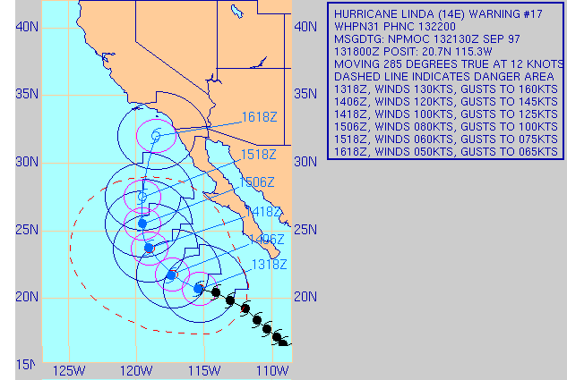
Though it did not strike the California coast, Hurricane Linda in 1997, a strong El Ni�o year, caused concern to forecasters. Linda was the strongest storm ever observed in eastern Pacific waters with winds estimated at 184 mph (294 km/h), Category 5, and some storm advisories suggested the possibility of the storm hitting San Diego as a minimal hurricane or strong tropical storm. However, Linda weakened and turned back out to sea before approaching San Diego.
Forecast Track for Hurricane Linda 13 September 1997 Projecting a Landfall on Southern California Courtesy Navy/NRL Tropical Cyclone Page
In the wake of Linda, however, was Hurricane Nora. Nora peaked at a Category 4 storm with peak winds at 130 mph (215 km/h). It moved up the Baja Coast making landfall twice. On the second landfall, the storm moved northward and crossed the border into the US at the California-Arizona state line as a tropical storm. It was the third tropical storm known to enter Arizona, though it dissipated into a tropical depression within hours. Rainfall in the desert was heavy with the largest total recorded in the Harquahala Mountains of Arizona: 11.97 inches (304�mm). In other locations across Arizona, California, Nevada, and Utah, more than 3 inches (76�mm) fell. Totals not unusual for a tropical storm, but in many areas the accumulations were comparable to a typical year's accumulation.
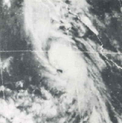
Satellite Image of Tropical Storm Kathleen 9 September 1976 Image Credit: NOAA
My focus in this piece is tropical storms hitting Southern California as wind storms. I acknowledge that many tropical storms have had detrimental affects on Southern California and eastward into Arizona and the US Southwest not as wind storms but as rain storms. For example, Hurricane Kathleen in 1976 struck Baja California and moved northward across the US-Mexico border. As the storm dissipated, it brought torrential and record rains to the desert regions of California and Arizona. At Yuma, Arizona, the sustained winds as the storm passed reached 57 mph (90 km/h) and the rains in the mountains of southern California ranged from 6 to 12 inches (150-300 mm) in accumulation. The moisture from Kathleen continued to flow northward and contributed to as much as two inches (50 mm) of rainfall in parts of Montana.
Learn More From These Relevant Books Chosen by The Weather Doctor
Written by Keith C. Heidorn, PhD, THE WEATHER DOCTOR,
October 1, 2013
The Weather Doctor's Weather Almanac: The San Diego Hurricane of 1858 �2013, Keith C. Heidorn, PhD. All Rights Reserved.
Correspondence may be sent via email to: see@islandnet.com.
For More Weather Doctor articles, go to our Site Map.
Now Available
The Field Guide to Natural Phenomena: The Secret World of Optical, Atmospheric and Celestial Wonders by Keith C Heidorn, PhD and Ian Whitelaw


 San Diego has a long history. The Presidio and Mission of San Diego was founded in 1769, the first European settlement in what is now California. Following the Mexican-American War of 1846�1848, the territory of Alta California, which included San Diego, was ceded to the United States by Mexico. In 1850, California became the 31st state in the United States of America. The village of 500, was incorporated as a city that year and the seat of the newly established San Diego County. The census of 1860 showed the population had increased to 731, and further blossomed in the succeeding decades.