Over this December past, I bought and read Mark Monmonier's new book Lake Effect: Tales of Large Lakes, Arctic Winds, and Recurrent Snows. As you might gather from the title, the book looks at lake-effect snows (LES) with particular focus on the North American Great Lakes region. The author resides in the LES belt south of Lake Ontario in northern New York State. The book was a pleasure to read, and it gave me some new insights to the scientific advances in the cause and prediction of lake-effect snows (and rains). As someone who has spent much of his career dealing with the impacts of weather on human society, I was pleased to learn new insights into the impacts of these snows on the urban areas surrounding the Great Lakes.
Having spent two thirds of my life in the Great Lakes region, I have been familiar with their impacts on the local climate, particularly the middle-third period in southern Ontario where I lived on the edge of one of the major LES impact areas. After leaving the region, I spent a number of years on Vancouver Island, and it is there I first heard about sea-effect snows. Although they rarely affected the extreme southern parts of the island around Victoria, there were occasional events along the eastern coast when strong arctic outbreaks pushed out through the mountain barrier on the continent and over the warmer sea waters of the Salish Sea (formerly known as the Strait of Georgia).
While I don't have a annual distribution climatology for such events on the mid-Vancouver Island east coast, I would imagine that January and February would see the higher frequency of such events when the cold arctic air over the interior has the “strength” to break through the coastal mountains and push out over the Salish Sea. I base this hypothesis on the fact that the waters of this sea are not as warm as the autumn Great Lake waters, but their surface temperature does not change much over the year. Thus, the trigger factor should be the extreme cold air of the outbreak, and these are most likely to be coldest during January and February when the greatest of the arctic air masses form over the arctic regions.
Though snowfall amounts are not as great along the eastern Vancouver Island coast as those over the southern Great Lake shores, the sea-effect snowfall from arctic outbreaks can be significant. The areas of highest likely accumulation, according to Environment Canada meteorologists, are found south of Nanaimo in the Duncan-Ladysmith area and also south along the Malahat, a stretch of undulating hills (Malahat is a local native word meaning “caterpillar”) between Duncan and Greater Victoria.
Sea-effect snowfalls are also known ocean-effect snows and as bay-effect snows, particularly along the US East Coast from New England (Massachusetts Bay) to the northern Mid-Atlantic States (Chesapeake Bay). They occur in Asia, northern Europe, and even more subtropical regions such as Florida and perhaps even Cuba. The greatest expression of sea-effect snows in the world appears to be on the western shores of northern Japan where accumulations and event falls are as deep or deeper than those along the New York State LES regions.
Causes of Sea-Effect Snowfalls
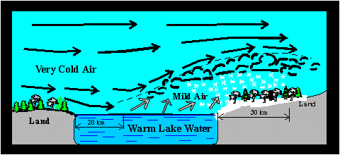
The mechanism for sea-effect snows is the same as that for lake-effect snows. (For my discussion on LES, see my article What Causes Lake-Effect Snow Squalls) In simplest terms, these snow squalls form when a cold continental air mass, passing for a sufficient distance over the relatively warm waters of a large body of water, picks up moisture and heat in passing which lead to upward convective development. This air is then forced to drop the moisture in the form of snow upon reaching the downwind shore. The upward motion of air increases further along the lee shore where the land surface slows down the onshore flow, creating a piling up or convergence of air. The air, having no place else to go, rises rapidly, triggering the formation of snow showers or squalls. Sloping or elevated terrain along the shoreline also enhances vertical motions.
Schematic Diagram of Lake-Effect Snow Conditions A similar process occurs with Sea-Effect Snowfalls
The intensity of the snowfall depends upon several factors: the temperature contrast between the warm water surface and the cold air passing over it, the over-water distance the air has to traverse (the fetch), and the regional weather situation. The distance these storms travel inland increases under higher wind speeds, while their direction is controlled by the winds flowing above the surface layer.
The key factor in predicting sea-effect snows is a temperature drop of at least 13 Celsius degrees (23 Fahrenheit degrees) between the sea water and the air at the 850 mb pressure surface (about 1500 m / 5000 feet).
Geographical Distribution
While sea-effect snowfalls can occur at anytime very cold air moves over warm waters for an adequate distance, certain regions are more prone to such snowfalls than others. The US northern East Coast and Pacific Northwest are prime areas for sea-effect snows in North American as are the Canadian Maritime provinces. In Europe, the area south of the North Sea, the Black Sea, the Baltic Sea and the Adriatic Sea are more likely to see sea-effect snows than other locations.
Perhaps the signature location for sea-effect snowfalls is the area along Japan's coastline with the Sea of Japan in the mountainous western Japanese prefectures of Niigata and Nagano on Honshu Island, and on Hokkaido Island. It is estimated that 90 percent of the snow falling on Sapporo, Japan comes from this source. (The Niigata/Nagano area, a very popular winter sports Mecca in Japan, is famed as the setting for a beloved Japanese novel, 'Yukiguni' ('Snow Country') by Nobel literature prize winner Yasunari Kawabata.)
North America
On the US East Coast, the so-called bay-effect snows are usually associated with cold arctic air moving across the warmer Gulf Stream waters offshore and then onto land, entering the coastal region on north to northeast winds. Climatologists estimate that on average two to four such events occur each year, usually dropping a couple of inches (around five centimetres) of snow each with occasional accumulations of 6-8 inches (15-20 cm). These events are called bay-effect snows because they occur most often around Massachusetts Bay (particularly Cape Cod and Cape Ann) and along the mouths of Delaware Bay and Chesapeake Bay. They have also occurred in the New York City area around the harbor and on Long Island.
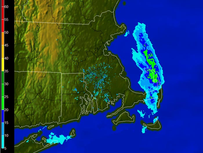
Radar image of a band of sea-effect snow forms off Massachusetts Bay and moves across Cape Cod. Image courtesy NOAA
One outstanding event produced a major snowfall in eastern Massachusetts on 13-14 January 1999. In an event analysis by Jeff Waldstreicher, the sea-effect was argued to be the major contributor to the 10-16 inches (25-40 cm) of snow that fell south of Boston. The event began as a rainstorm that changed to snow following the passage of a cold front. The front-trailing high pressure cell pushed cold northerly winds over the warm offshore waters off Cape Cod and onto the coast. Waldstreicher attributes as much as a foot (30 cm) of that snowfall was due to sea-effect conditions.
Sea-effect snowfalls over the eastern coast of North America have also been found along the Bay of Fundy in New Brunswick and along the south shore of the Gulf of St Lawrence in Quebec and the Maritimes.
On the US West Coast, the same conditions that can bring sea-effect snow to Vancouver Island, a coastal arctic outbreak, may also impact the US islands in the Strait of Georgia and Puget Sound and along the northeastern Washington coast, particularly at Port Angeles and in Kitsap County.
On the rare occasion, a frigid air mass descending from the Canadian Arctic down the Mississippi Valley can invade the US Gulf Coast and as it blows across the Gulf of Mexico, it can bring sea-effect snow showers to Florida and perhaps as far south as Cuba. In January 2003, such a situation brought a dusting of snow to Florida from from Cape Canaveral to Daytona Beach. On that day, the US National Weather Service issued this Weather Statement:
SPECIAL WEATHER STATEMENT
NATIONAL WEATHER SERVICE MELBOURNE FL
1048 AM EST FRI JAN 24 2003
...FLURRIES OCCURRING ALONG THE COAST OF EAST CENTRAL FLORIDA...
THE COMBINATION OF VERY COLD TEMPERATURES AND STRONG NORTH TO NORTHEAST WINDS ARE PRODUCING OCEAN EFFECT SNOW FLURRIES OFFSHORE AND ALONG THE COAST OF EAST CENTRAL FLORIDA...ESPECIALLY NEAR CAPE CANAVERAL. THESE FLURRIES WILL CONTINUE INTO THE EARLY AFTERNOON HOURS BEFORE TEMPERATURES MODIFY CAUSING THE LIGHT SNOW AND FLURRIES TO CHANGE OVER TO VERY LIGHT RAIN OR DRIZZLE. NO ACCUMULATION OF SNOW IS EXPECTED. THE LAST TIME FLURRIES WERE RECEIVED ACROSS EAST CENTRAL FLORIDA WAS IN DECEMBER OF 1989.
Europe
The majority of sea-effect snowfalls appears to occur on the southern coasts of the North Sea and Baltic Sea when cold air drives out of Scandinavia and Eastern Russian and across the warmer sea waters. These particularly impact eastern areas of the United Kingdom, the southern and eastern Swedish coasts and, on occasion, the Danish coast.
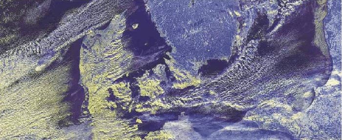
Cold outbreak brings sea-effect snows off the Baltic Sea to the eastern Danish coast on January 6, 2003 Image courtesy NASA
In the United Kingdom and eastern Ireland, locations around the Irish Sea coast such as Liverpool and the West Midlands will on occasion see snows attributed to cold northwesterly winds moving across the warmer sea waters. Further north, areas of Scotland in the Scottish Highlands and the city of Inverness off the Moray Firth experience sea-effect snowfalls. One notable snowfall event resulting in the 2009 Hogmanay celebrations in Inverness being canceled as police warned party goers of "treacherous" weather conditions in and around the Highland capital, which included cold temperatures, high winds, and snow. (Hogmanay is a multi-day Scottish celebration of the New Year that includes many outdoor events.)
One instance of an exceptional sea-effect snow in England occurred over the period 10-20 January 1987. The heavy snow accumulation covered portions of East Anglia and the Thames Estuary. The highest reported snowfall fell at Leigh-on-Sea: 44 cm (17 inches).
Cold air flowing off the continent and across the Adriatic Sea can, on occasion, bring sea-effect snowfalls to northern Italy.
Another region where sea-effect snowfall can be heavy is along the southern shores of the Black Sea in Turkey and Georgia. One notable event occurred in February 2005 when Istanbul and surrounding area was hit with as much as 50 cm (20 inches) of snow over a few days. In this event, the cold air flowed out of Siberia south and westward. As it crossed the Black Sea, the surface temperature differential between the water surface and the 700 mb level was measured to be as much as 20 Celsius degrees (36 F degrees).
Asia
Cold air out of Siberia and far eastern Russia moving across the warm waters of the Sea of Japan can bring sea-effect snows to Korea and Japan. Korea may also receive sea-effect snows coming off the Yellow Sea under frigid outflows from eastern Russia.
In Japan, sea-effect snowfalls have their greatest impact over the area along Japan's coastline with the Sea of Japan in the mountainous western Japanese prefectures of Niigata and Nagano on Honshu Island, and on Hokkaido Island. This snowfall is instrumental in providing the heavy snows characteristic of the Japanese winter playgrounds around Sapporo on Hokkaido Island and Nagano on Honshu Island, former sites of the Winter Olympic Games. The Niigata/Nagano area, a very popular winter sports Mecca in Japan, is famed as the setting for a beloved Japanese novel, Yukiguni (Snow Country) by Nobel laureate in literature Yasunari Kawabata.
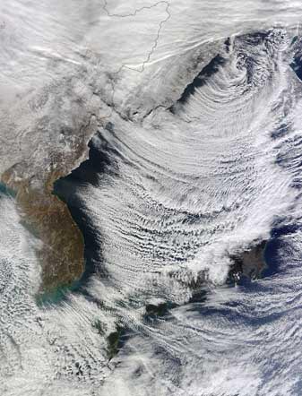
Cloud streets form with cold air moving across Sea of Japan bringing sea-effect snow to western Japan, December 25, 2010 Image courtesy Moderate Resolution Imaging Spectroradiometer (MODIS), NASA
One of the prime conditions that causes such heavy snows in both snowy areas of Japan in the Japanese Alps is that the cold Siberian air outflow of prevailing northwesterly winds over the warm sea waters is part of the great Asian winter monsoon. It has been estimated that as much as 90 percent of Sapporo's annual snowfall of 630 cm (248 inches) can be attributed to this impact. The high terrain lifts the air and causes it to cool rapidly and thus drops its moisture load on this snowcoast.
The snowfall in this sea-effect belt can be prodigious. The greatest snowfall outside North America, according to extreme weather sage Chris Burt, was measured at the Japanese city of Tsukayama on 30-31 December,1960 when 173 cm (68.2 inches) fell. Tsukayama is located in the coastal mountains inland from the Sea of Japan along Honshu’s west coast. The coastal city of Takada in the same area holds the distinction of the snowiest sea-level location in the world with an annual average of 6.65 metres (262 inches). An incredible snowfall buried the city on 8 February 1927 with 149 cm (58.6”) accumulating in 24 hours
Update: 21 February 2013: In Chris Burt's Weather Extremes blog today, he reports that a new Japanese all-time snow depth record was set on this date at Sukayu Onsen, Aomori on Honshu Island in Japan: an astounding 515 cm (202.8” or almost 17’). There "the average annual snowfall measurement of 1,764 cm (694.5”) makes it the snowiest site in the world for which climate data is available." Much of the snow falls as sea-effect snow. For more details, see his Weather Underground blog.
Learn More From These Relevant Books Chosen by The Weather Doctor