Nothing elicits news headlines better than weather out of its expected season. As our sources of news expand, particularly across the meteorologically diverse continent of North America, we hear more and more of “unusual” events in both time and space. And though the media try to convince us that anything that does not happen along a simple progression of the seasons is “rare”, I would say that if we ever experienced truly “normal” weather, in that meteorological sense, it should rate the biggest headlines. (Reminds me of a piece of trivia parody: On this date in history: Nothing happened.)
In this installment of the Almanac, I am looking at late-season snowstorms. Major winter storms occurring later than April 1st is the marker I am using for these events, and I will be rather provincial and consider only those that had an impact on eastern North America, mostly from the Mississippi Valley to the Atlantic Coast. One of the reasons for this geographic choice is that significant snowfalls can occur west of this region almost all year long, with perhaps the exclusion of the American Southwest, and Mexico. Some of these late snows fall at higher elevations and some further north, such as in the Canadian Prairies where colder arctic air may drop down from the north and produce snow in even the high summer months.
A couple late-season events sit high in my personal memory bank. One snowfall hit across the Great Lakes region in April 1966 as I was preparing to return home to Illinois from Michigan for the summer break. The amount of snow was not great but enough to cover the new green. A second snowfall followed in its wake in May of that year when an 11 May snowfall accumulated 1.7 inches (4.3 cm) at Chicago's O'Hare International Airport, the city's latest measurable snowfall on record.
The second event was much more spectacular, though I do not remember the year but it was in the 1980s. I had gone to attend a workshop at a hotel north of Toronto. Before I left on the Sunday afternoon, I had been working outdoors in shirtsleeves and brought with me only a spring jacket. But on Thursday night, the snow began, and when the workshop ended Friday morning, many of us could not leave and were forced to stay another night. My ride and I had started out to make the journey westward, about an hour's drive for me, but within a mile or two from the inn, we could not safely negotiate the snow-drifted roads. Only those who resided in the northern reaches of Greater Toronto were able to make it home that afternoon.
Late season snowstorms hinder the flow of traffic — road and air — over the region where they occur, and can put the final nail in a municipality's snow removal budget. In some instances, the storm can cause or enhance spring flooding, particularly if the snow falls over several days, then quickly melts with the return of spring-like temperatures. Depending on the course of that particular spring, a late snowfall may have great detrimental effects on plants and wildlife, particularly deciduous trees that have just opened their spring leaves. The leaves catch more of the snow than bare branches would and thus place a weight burden on the tree that may cause branches to snap.
Not all impacts need be adverse. For example, snowfall that comes quickly, but melts slowly can allow more water to soak into the soil or forestall local flooding.
The accounts that follow summarize some of the major late-season snowstorms to strike the eastern regions of the United States and Canada, some came in May and June, but most hit in April. One was an infamous snowstorm that hit in June 1816, and it is that one I will start with.
The Summer Snow of 1816
The year of 1816 has become infamously known as The Year Without a Summer and as Eighteen Hundred and Froze to Death. I have written about the full account of that year elsewhere. It was a disastrous year for New Englanders and the southern Quebecois, as cold spells that hindered crop advancement punctuated the summer. But the most famous single event of that year was the June snow that hit southern Quebec and northern New England.
On 5 June, a strong weather system was about to enter the New England scene. During the night hours of the 5th, rain began to fall over Quebec City. The temperature, however, soon plummeted toward the freezing mark so that by the morning of the 6th, the rain was mixed with snow.
Meanwhile in New England, the weather of the 5th gave hardly a hint of what was to come as daytime temperatures were seasonable. The North Star of Danville, Vermont reported:
[June 5] “was perhaps as warm and sultry a day as we have had since September . . . but on Thursday morning the change of weather was so great that a fire was not only comfortable, but actually necessary. The wind during the whole day was as piercing and cold as it usually is the first of November and April. Snow and hail [ice pellets] began to fall about ten o'clock A.M., and the storm continued till evening, accompanied with a brisk wind, which rendered the habiliments of winter necessary for the comfort of those exposed to it....Probably no one living in the country ever witnessed such weather, especially of so long continuance.”
At Elizabethtown, New York, the cold front passed before dawn, and at 7:30 am a three-hour snow storm began. Throughout the day, snow showers were general, blown on icy westerly winds that froze the ground and destroyed most garden vegetables.
Benjamin Harwood, a Bennington, Vermont farmer, entered the following in his diary for the date:
“It had rained much during the night and this morning the wind blew exceedingly high from NE, raining copiously, chilling and sharp gusts. About 8 A.M. began to snow--continued more or less till past 2 P.M. The heads of all the mountains on every side were crowned with snow. The most gloomy and extraordinary weather ever seen.”
Joshua Whitman at North Turner, Maine wrote of cold northwest winds with snow squalls. Adino Brackett in Lancaster, New Hampshire also reported snow, commenting, “This is beyond anything of the kind I have ever known.” Snow was reported in Canada at Kingston, Ontario, Montreal and Quebec City, Quebec as well as Danville and Montpelier, Vermont; Warren and Bangor, Maine; Amherst, New Hampshire; Plymouth, Connecticut; Geneva and Oneida County, New York; and Waltham, Massachusetts. Reports of flurries came from as far south as north of New York City along the Hudson River ten miles north of the tidewaters.
In his autobiography, Chauncey Jerome recalled walking to work in Plymouth, Connecticut that day dressed with thick woolen clothes and overcoat, his hands becoming so cold that he had to don mittens.
Benjamin Harwood's diary entry of 7 June tells us: “snow remained on Sandgate and Manchester Mountain past noon or as late as that."
Late on the 7th, a second cold front crossed the region, bringing significant snowfall to the area. From the highlands of Vermont came reports of 5 to 6 inches (12-15 cm) of snow with drifts to over a foot (30 cm). At Lunenberg, Vermont, Dr Hiram Cutting measured 5 inches (12 cm) on the ground. Amounts at other locations ranged from "a plentiful fall" at Portland, Maine, a foot at Cabot, Vermont, and 6 inches (15 cm) at Barnard, Vermont to "a few flakes" at Middlebury, Connecticut, Waltham, Massachusetts and Salem, Massachusetts. The Danville North Star reported a "kind of sleet or exceedingly cold snow.
“Snow and freezing temperatures continued through the 8th. The Quebec Gazette observed that on the morning of the 8th, "the whole of the surrounding country was in the same state, having...the appearance of the middle of December." On the south shore of the St. Lawrence River, banks of snow reached the axletrees of the carriages. The Rev. Sparks in Quebec City wrote: "...bleak cold very uncommon weather for the season. It snowed a little the whole day--at 10 at night the ground was completely covered.”
The cold too was intense. Benjamin Harwood wrote in his diary entry for the day:
"The awful scene continued. Sweeping blasts from the North all the forepart of the day, with light snow squalls....So cold in the morning that we were absolutely compelled to send for our mittens and wear them till near noon-day."
The effects of the five-day frigid spell were staggering, especially to a basically subsistence agricultural system. In Quebec, great numbers of birds and newly-shorn sheep perished in the cold. Gardens and wild fruit trees which had come to blossom suffered severely. Fortunately, the cold spring had prohibited many trees from coming to full leaf or blossom thus averting more extensive frost damage. The snow, ironically, actually protected many of the young crops from the severe frosts and thereby reduced the degree of damage.
The summer of 1816 would continue to send frosty weather across the region, but no further snowfall of any magnitude was reported.
Wrong Tune for June
The June snow of 1816, however, was not the only June snow in the New England and Northeast US. David Ludlum in his two-volume work Early American Winters reports June snowfalls in 1773, 1825, 1833, 1842, 1843, and 1869. The 1773 snow fell in New England measuring two inches (5 cm) on the night of 11 June at Newbury, Vermont. On 5 June 1825; Freeman's Journal, published in Philadelphia reported snow covered the ground in Pennsylvania, but no location was given. The winter of 1833 brought late-season snows to Vermont on 9 June 1833. At Randolph, Martin Flint observed the “mountains white with snow” and a little in town. At Burlington there were snow squalls in the morning.
The mid-June snowfall in 1842 brought back memories of three decades earlier. This was the most widespread June snowstorm during the pre-Civil War years in New England and New York. Snow was also reported west in Ohio where Professor Elias Loomis in Cleveland noted some flakes falling during his 10 June evening observations. The cold air moved eastward dropping several inches in upstate New York. Essex County had four inches by morning. In Vermont, snow was being reported in the early morning hours at Burlington and Vergennes. The total snowfalls in Vermont included 10 to 12 inches (25-30 cm) at Barton and Irasburg; 3 inches (7.6 cm) in Burlington.
The Blizzard by Cornelius Kreighoff, 1858
Further east in New Hampshire and northwest Maine, around a foot of snow accumulated, Berlin, New Hampshire getting 11 inches (28 cm). The New Hampshire Patriot reported: “This beats the year 1812 and all others within our memory.” Snow was also reported in New York's Catskill Mountains, Harrisburg, Pennsylvania, and even Boston, Massachusetts. Snow was observed at elevation in the Appalachians in Pennsylvania and Maryland.
Up to two inches (5 cm) of snow fell across Ohio on 5 June 1859. The last of these Northeastern US June snowfalls in the nineteenth century again was observed in Vermont in 1969. No specific information is given by Ludlum except that on several occasions that month, snow fell around Burlington as reported by the local Free Press.
Since the nineteenth century, I could find no record of significant snowfalls during June. Undoubtedly, snow would have fallen at elevation since at Mount Washington Observatory in North Conway, New Hampshire, the present climate normals show only July has not recorded a snowfall of over 2 inches (5 cm) at the summit there. Their single-day June record is 5.1 inches (13 cm) in 1988.
May: You Don't Say?
May snowstorms in the region under discussion are more common, particularly during early May. Many cities in the Great Lakes and the Northeast have experience their latest cold-season snowfalls in early May. Among those cities where the last recorded measurable snowfall has come in the last half of May are: Minneapolis, Minnesota (24 May) in the west, and Buffalo, New York (20 May) in the east.
One of the earliest May snows of note to be recorded in the region fell on 4 May 1774 when around 4 inches (10 cm) fell from Virginia northward to southern New England. Both George Washington and Thomas Jefferson noted the snows in their diaries.
On 8 May 1803 a spring storm dumped heavy snow from southern Indiana to New England. On 4 May 1812, a storm dropped snow from Philadelphia to Maine, with a foot (30 cm) near Keene NH, and nine inches (22.9 cm) at Waltham, Massachusetts.
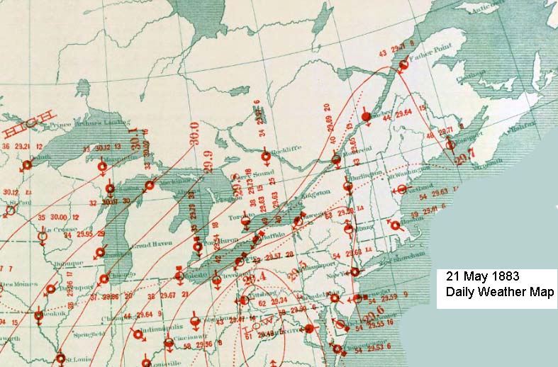
Weather Map for 21 May 1883
A substantial May snowfall fell across western Ohio in May 1883. On the morning of the 21st, a light rain began which turned to snow by mid-morning. In Shelby County around six inches (15 cm) had accumulated by the next morning. Since the temperature was near freezing, much melted as it fell and the estimate for the storm was 15-20 inches (38-51 cm) in Sidney. Around three inches (7.5 cm) fell at Hamilton.
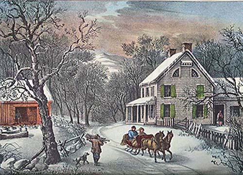
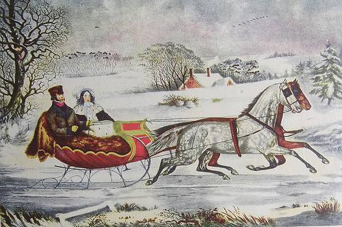
American Homestead Winter by Currier & Ives, 1868
In 1889, 7 May saw substantial 24 hour snowfalls in upstate New York: 7.2 inches (18.3 cm) at Buffalo; and 10.7 inches (21.2 cm) at Rochester. Two storms struck in May of 1894. The first on the 20th, dropped as much as ten inches (25 cm) of snow across Kentucky, Tennessee and Virginia. Four days later, six inches (15 cm) blanketed Kentucky.
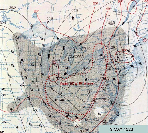
Detroit, Michigan was the focal point of a snowstorm in 1923 that affected southern Michigan. Starting on the 8th and concluding the next day, six inches (15 cm) were reported on the ground in Detroit and 6 to 9 inches (15-23 cm) blanketed the area westward to Ann Arbor. Further north and west, snow depths of around a foot (30 cm) fell around Flint and Lansing. The heavy snow caused much tree damage as many branches were already fully leafed and held the falling snow. As with the 1883 storm in Ohio, the snow accumulation damaged many trees around the region, and some took out power and telephone lines when they fell. Detroit would record May snowfalls in 1912, when 1.5 inches (3.8 cm) fell on 13 May; and in 1910 when a trace fell on the 31st.
Weather Map for 9 May 1923
Chicago, Illinois received its greatest May snowfall on 1-2 May, 1940 when 3.7 inches (9.4 cm) accumulated. At the time is was also the city's latest recorded snowfall. The latest snowstorm of record for the state of Iowa struck on 28 May 1942, dropping ten inches (25.4 cm) at LeMars, eight inches (20.3 cm) at Cherokee, and 7.5 inches (19 cm) at Waukon.
During the World War II years, two May snowstorms moved across New England. The first struck on 10 May 1943 bringing up to 3 feet (90 cm) of heavy wet snow reported in parts of New Hampshire. The second hit the same day in 1945 with 7 inches (17.8 cm) of snow on Portland, Maine and 10 inches (25.4 cm) on parts of Massachusetts. Prior to reaching the coast, the storm dusted Fort Wayne, Indiana with 0.3 inches (0.76 cm) of snow, their latest measurable snow to date.
A storm on 9 May 1966 covered northeastern Ohio and western Pennsylvania and extended across parts of New York State with record May snows: including 3.1 inches at Pittsburgh, Pennsylvania, 5.4 inches (13.7 cm) at Youngstown Ohio, and 8 inches (20.3 cm) in the southern Adirondacks. The storm then hit Pennsylvania, New York State, and southern and central New England. By the end of the day on the 10th, among the heaviest snowfall accumulations there included 27 inches (68.6 cm) at Slide Mountain New York, and 20 inches (50.8 cm) at Norwalk Connecticut. At Boston, Massachusetts, the snow was the first May snow in 107 years of records. A couple of days later (11 May), a second wintry blast moved through Chicago, leaving 1.6 inches (4.1 cm) at O'Hare International Airport, the latest measurable snowfall in the Windy City on record.
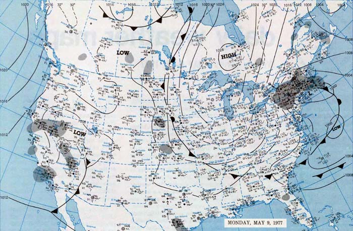
Weather Map for 9 May 1977
On 9 May 1977, a storm off the Atlantic coast brought astounding snowfall to New England including 12.7 inches (32.3 cm) at Worcester, Massachusetts, and 7.5 inches (19 cm) at Providence, Rhode Island, the only instance of measurable snowfall observed in May during the twentieth century there. To the south, more than a foot (30 cm) of snow fell at the Mohonk Mountain House resort, west of New Paltz, New York while at elevation, the Catskills saw as much as 27 inches (68.6 cm). In the Pocono Mountains of Pennsylvania, 8 inches (20 cm) of snow fell.
Finally, a spring snowstorm moved across Upper Michigan and eastern Wisconsin on 10 May 1990. Snow accumulations ranged from eight inches reported at Muskego and Hartford, Wisconsin with to up to 12 inches (30 cm) at Marquette, Michigan. The heavy wet snow, combined with strong, gusty winds damaged thousands of trees and brought down power lines.
April, Still Not Too Late
An April snowstorm, though unwelcome, is not a terribly unusual occurrence in the northeastern areas of the United States. Several cities from Minneapolis in the west, through Chicago and Detroit, to Buffalo, New York and Burlington, Vermont in the east have their average last snowfall date in April, and all major cities north of the Ohio Valley and the Mason-Dixon Line have had at least one measurable snowfall in April, including New York, Philadelphia, and Washington DC where the latest snows have fallen during the last week of the month. Cities as far south as Atlanta, Georgia have also seen April snowfall. In fact, several eastern cities have seen two feet or more fall in April storms (Detroit and Akron, Ohio among them).
I feel that mid-spring (April) snowstorms have the same headline value of winter tornadoes, entities that seem out of place, yet are more normal than rare. [I believe that statistically, the frequency of a rare event must be no more than once every fifty years.] They rate headlines in a media view that is shocked by anything outside their simple view of the world. I have often, and perhaps overused, the analogy of the Camelot view of the world that nature works according to royal decree. But nature tells us that when moist tropical airs of spring meet the last cold air masses of winter, significant snows may fall. Whether we like it or not.
That said, there have been some mid-spring snowstorms that have stood out from the rest. Many seem to have occurred on 1 April as a cruel April Fool's Day joke as March roared out like a lion.
One of the earliest April snowstorms of note struck New England on the first of April 1780 during the midst of the Revolutionary War. It had moved in on 31 March as a nor'easter dropping snow along the Atlantic coast. In New Haven, Connecticut, it was reported as “ankle-deep” in the diary of Ezra Stiles. General George Washington wrote “The snow which fell yesterday and last night was about 9 or 10 inches [22.9-25.4 cm] deep upon a level.” The general was at Morristown, Pennsylvania at the time. In Trappe, Pennsylvania, Henry M. Muhlenberg concurred, writing in his journal that “the snow is very deep.”
The initial April day of 1786 also brought a storm, again likely a nor'easter, to New England. The storm dropped a foot (30 cm) of snow from New Jersey northward to New Hampshire.
Snowstorm by Currier & Ives
Early in the next century, another April 1st snowstorm, dubbed “The Great April Fools Day Snow of 1807” tracked across the lower Great Lakes, beginning on 30 March then through Virginia to the Atlantic Coast. The storm appears to have moved from the lower Tennessee Valley where it left 11 inches (27.9 cm) of snow on Vincennes, Indiana in the final days of March. The brunt of the heavy snows then hit Pennsylvania, New York and New England. There accumulation reports gave astounding numbers: 52 inches (132 cm) at Montrose, Pennsylvania; 54 inches (137 cm) at Utica, New York, 42-48 inches (107-122 cm) at Norfolk, Connecticut, and in Vermont, 52 inches (132 cm) at Lunenburg, 60 inches (152 cm) at Danville, and 48 inches (122 cm) at Montpelier. It appears that most areas in the Northeast at elevation received a foot or more of snow.
That the storm was a major cyclonic system is seen by the low atmospheric pressures measured at Philadelphia and New York City of 28.75 inches Hg (973 mb) or less. The storm produced gale-force winds along the coast, causing high waters in New York Harbor and damaging some ships. The Danville (Vt) North Star observed: “We presume there never was such a time known here at this season of the year. The snow is considered to be five feet deep on a level, in many places covering the fences...”
Winter Scene by Currier & Ives, ca 1850s
The next significant April snow event was more astounding for the place as it was for its date. The snow of April 1849 hit the southern US in mid-month. All seemed normal until the 15th when snow and a killing frost struck the deep South. Measurable snow whitened Charleston, South Carolina and a six inch (15 cm) accumulation was observed at Wilmington on the Cape Fear River. In Camden, South Carolina , the Journal reported “a snow fall whitened the ground at Camden, the crops much injured. This is probably the latest snow ever known here.” In Marietta, Georgia, the snow storm lasted three hours. In Alabama, deep snow covered the mountains north of Huntsville. In Aberdeen, Mississippi, it snowed for a couple hours on the morning of the 16th.
Later in the century, heavy snow fell across the Northeast on 10 April 1894. Greatest accumulations included 31.5 inches (80 cm) at Salem Corners, Pennsylvania; 30 inches (76 cm) at LeRoy New York; 26 inches (66 cm) at York Pennsylvania; 14 inches (35.6 cm) at Waterbury Connecticut; and 9 inches ( 22.9 cm)at Providence Rhode Island.
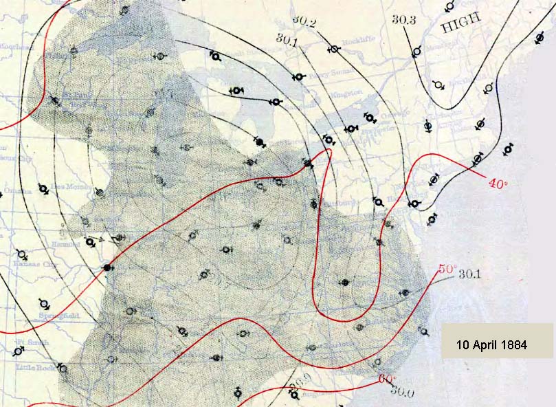
Weather Map for 10 April 1884
The twentieth century's first major April snowstorm in the eastern US tracked across Ohio and Pennsylvania around 19-20 April 1901, leaving more than a foot (30 cm) on the ground in many locations. In northeastern Ohio, Warren accumulated 35.5 inches (90.2 cm) over 36 hours and 30 inches (76 cm) in 24 hours, the state record for the month. Twenty eight inches fell at Green Hill. Akron set an April record with 15.6 inches which also pushed the month's total to a new record of 26.6 inches. The storm gave similar impacts in Pennsylvania where Pittsburgh's 12.7 inches (32.3 cm) helped push the month's total to 13.5 inches (34.3 cm), both April record amounts.
Two late April storms converged off the Atlantic coast and brought major snow accumulations to the central Appalachian Mountains 27-28 April 1928. The snowfall was reported to have been 40 inches (101.6 cm) in West Virginia. Over two feet (60 cm) fell on Bayard, West Virginia, 35 inches (88.9 cm); Somerset, Pennsylvania, 31 inches (78.7 cm); and Grantsville, Maryland, 30 inches (76.2 cm). Elsewhere, peak accumulations in the most effected states include 36 inches (91.4 cm) in Pennsylvania, 15.5 inches (39.4 cm) in Kentucky, 14 inches (35.6 cm) in Virginia, and 13 inches (33 cm) in North Carolina. The heavy snow snapped trees including many fruit trees.
The storm of 2 April 1975 moved through the Great Lakes to the Northeast adding howling winds to the heavy snow. At Mount Washington Observatory in New Hampshire, winds gusted to 140 mph (224 km/h), and hurricane-force winds hammered the coast. The blizzard shut down Chicago, Illinois with 10.9 inches of snow (27.7 cm), just a tenth of an inch (0.25 cm) off the record for the month and up to 20 inches (50,8 cm) fell across northeastern Illinois. In New England, two to three feet (60-90 cm) of snow buried parts of Maine and New Hampshire.
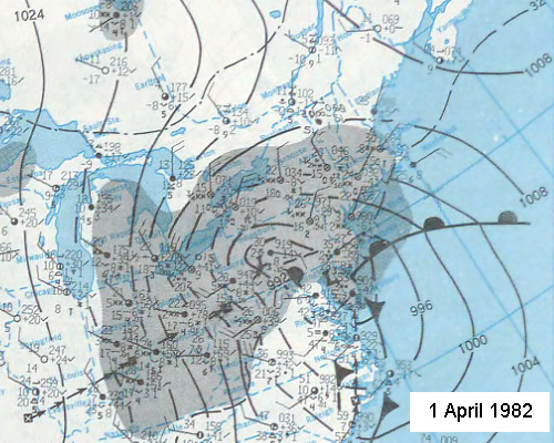
Weather Map for NE United States 5 April 1982 Courtesy, NOAA, US Department of Commerce
In April 1982, a major blizzard hammered the Northeast with heavy snowfalls during the 5th and 6th. Over a foot (30 cm) covered areas of Massachusetts and Connecticut with as much as 26 inches (66 cm) in Maine. New York City and Boston each reported a foot (30 cm) of snow. The snow was whipped into great drifts as the winds reached 70 to 80 mph (112-128 km/h) during the peak of the storm.
Two April snowstorms of note struck the east during April 1987. The first moved across the central Appalachians on the 5th dumping an incredible 50 inches (127 cm) in the mountains along the North Carolina—Tennessee border. Mount Mitchell, North Carolina accumulated 35 inches (89 cm). But the snowfall in Charleston, West Virginia provided the most impressive statistic. The 25 inches (63.5 cm) there not only broke the single snowstorm record for April, it demolished the old record for the total accumulation for the month which had stood at 5.9 inches (15 cm). Akron, Ohio also set a storm record with 20.6 inches (52.3 cm).
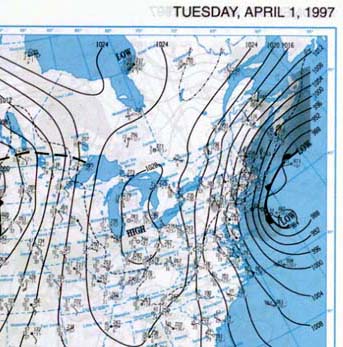
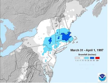
Weather Map for 1 April 1997
Snowfall totals (inches) for Storm
April Fool's Day of 1997 ended the century's major April snows striking particularly hard in Massachusetts. The heavy, wet snow covered Boston with 25.4 inches (64.5 cm) which, at the time, was the third greatest snowfall there and the greatest 24-hour accumulation ever. But Boston was not the snowiest place as nearby Milford, Massachusetts had 33 inches (83.8 cm). To the west, 37 inches (100 cm) fell at Jewett, New York.
I have purposely not considered snowstorms in the eastern Mississippi Valley or southern Canada in this accounting since April snows can be maddening but are not that uncommon. One, however, in 2000 deserves a bit of ironic noting. On the 9th of April, Montreal, Quebec was brought to a halt when 37 cm (14.5 inches) of snow fell, a new April daily snowfall record. While Montrealers pride themselves in being able to handle snow in their city, this one brought the city to a standstill because the contracts for snow removal had ended on April First.
The final storm of note is the one which put the seed into my head for this topic. It occurred last year (2012) over the 22-24 April period, mostly in Pennsylvania. Mild temperatures kept the event from being more widespread, but at elevations above 1500 ft (460 m), major accumulations occurred. Peak totals accumulating in the region include 23.7 inches (60.2 cm) at Laurel Summit, Pennsylvania; 16 inches (40.6 cm) at Arkwright, New York; 14 inches (35.6 cm) at Sylvania, Pennsylvania; 6 inches (15 cm) at Frostburg, Maryland; and 5 inches (12.7 cm) at Crawley, West Virginia. The heavy snow laden the now-leafed trees which led to many falling and causing widespread power outages. In the warmer air, heavy rains fell, with accumulations of 2-4 inches (50-100 mm) of rain in southern New England.
A Final Note on April
Though it sits outside our zone of focus, I must mention the record April snowfall that fell in April 1921 in Colorado. Over the 24-hour period during 14-15 April, a world daily record snowfall fell at Silver Lake, Colorado (in the mountains just west of Boulder): 75.8 inches (192.5 cm). The storm total accumulation over a 32.5 hour period registered an astounding 95 inches (241 cm).
And not to be outdone, the world-record April-storm snow accumulation hit further west in the very snowy Sierra Nevada Mountains of California. There, over a four day period from 20 to 23 April 1880, an incredible 194 inches (493 cm) — over 16 feet (nearly 5 m) — fell at the Sierra Nevada Railway's summit station of Norden.
Thanks to Chris Burt's blog: Weather Extremes for these April record tidbits]


 Late season snowstorms hinder the flow of traffic — road and air — over the region where they occur, and can put the final nail in a municipality's snow removal budget. In some instances, the storm can cause or enhance spring flooding, particularly if the snow falls over several days, then quickly melts with the return of spring-like temperatures. Depending on the course of that particular spring, a late snowfall may have great detrimental effects on plants and wildlife, particularly deciduous trees that have just opened their spring leaves. The leaves catch more of the snow than bare branches would and thus place a weight burden on the tree that may cause branches to snap.