When the Great Lake waters heat over the summer, they retain a large portion of that heat into the autumn months. This heat is instrumental in the formation of lake-effect rain and snow as colder polar air descends across them during the autumn. The excess heat in the water also produces large temperature differences between the water and the overrunning cold air that induces convective currents to rise from the surface. Under the right conditions, these updrafts may form spinning vortices similar to dust devils on land. Such phenomena are known as waterspouts, and they differ from their marine counterpart only by the salinity of the water surface below.
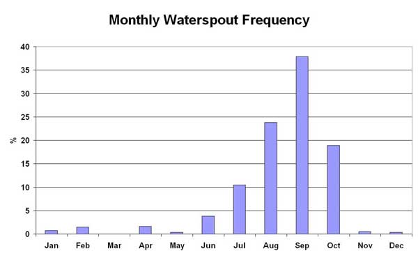
The excessive heat of the Spring and Summer of 2012 in the Great Lakes region has resulted in a large number of waterspouts to be observed in July and August of that year, about a month ahead of the usual frequency peak of September according to a Great Lakes waterspout climatology. In that climatology, August ranks second and October, third. All other months average below 10 observations per month.
Monthly waterspout frequency distribution. From NOAA Mariners Weather Log, 2004
Great Lake waterspout formation typically occurs when cold arctic air moving across the waters, sets up a large temperature differences between the warm surface water layer and the overriding cold air. Cool, unstable air masses passing over the warmer waters allow vigorous updrafts to form, which can tighten up into a spinning column. The cool, moist air supports a full condensation funnel despite the weaker rotation. The waterspouts generally last from about two to twenty minutes and move at speeds of 18 to 28 km/h (11 to 17 mph).
It therefore comes as no surprise that Lake Erie, the shallowest and warmest of the Great Lakes records the highest number of waterspouts, with Lake Ontario and Lake Huron/Georgian Bay following in total numbers. Lake Superior has the fewest observed waterspouts.
The Great Lakes are not the only freshwater bodies to produce waterspouts, almost any large lake is capable if conditions are right, and any lake can have a waterspout observed if a tornado moves across its waters. Inland waterspouts have been observed over Lake Tahoe and the Great Salt Lake in the US, Switzerland�s Lake Zurich, and Peru's Lake Titicaca, to name just a few inland locations.
Waterspout Formation
A decade ago, I wrote a Weather Almanac piece on waterspouts entitled Water Twisters. In it, I wrote:
�Before continuing, I want to narrow the discussion a bit by distinguishing between the two types of waterspouts following Tom Grazulis' definition in his book Significant Tornadoes. Grazulis splits them into tornadic waterspouts, which are true tornadoes formed in association with a severe thunderstorm and which happen to touch down on or cross a water surface; and true, or fair-weather, waterspouts, which form over the waters and dissipate almost immediately upon touching land. It is the latter form upon which I will focus herein....�
The same distinction will be followed here.
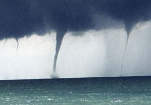
A true waterspout forms over the water and is not usually accompanied by a strong storm cell as is the tornadic waterspout. They commonly develop beneath lines of rapidly growing cumulus congestus clouds. These cloud lines can be quite shallow, averaging between 3600 and 430 metres (12,000 to 14,000 ft) deep with bases about 610 m (2000 ft) above the surface. The waterspout funnel forms in the rising air just ahead of any rainfall from these clouds in association with warm water temperatures and high humidity in the lowest kilometre of the atmosphere. Being small-scale circulation phenomena, waterspouts are not affected by the Coriolis force, and thus they have been observed to spin both anticlockwise (cyclonically) and clockwise (anti-cyclonically).
Much of our knowledge about waterspouts comes from the pioneering work of Dr Joseph Golden, who observed much of the behavior of marine waterspouts in the waters surrounding the Florida Keys during the 1960s and 1970s.
Golden defined the waterspout as a �funnel which contains an intense vortex, sometimes destructive, of small horizontal extent and which occurs over a body of water.� Waterspouts fall within the class of atmospheric phenomena known as convective vortices that includes tornadoes, dust devils, landspouts, and hurricanes. These are circulations driven by, or associated with, either dry or moist convection.
Golden distinguishes five distinct stages in a waterspout's life cycle:
Dark spot: A prominent circular, light-colored disk first appears on the surface of the water surrounded by a larger dark area of indeterminate shape with diffuse edges. This light inner circle measures approximately 7.5 to 31 metres (25 to 100 feet) in diameter.
Spiral pattern: Next, a pattern of light- and dark-colored surface bands spirals out from the dark spot on the water surface. This stage represents the primary growth phase of a waterspout in which the vortex intensifies while simultaneously expanding its radius of influence.
Spray ring: A dense swirling ring (annulus) of sea spray, called a cascade, appears around the dark spot with what appears to be an eye. Stage 3 marks the point at which convergence of inward-flowing angular momentum reaches a critical value in the ring surrounding the dark spot. This accumulation of angular momentum is accompanied by a gradual increase in wind speeds. If the winds attain a speed of 83 km/h (52 mph), a spray ring arises, and the lower portion of the waterspout begins to advance.
Mature vortex: The waterspout, now visibly extending from the water surface toward the overhead cloud mass, achieves maximum organization and intensity. The mature funnel often appears hollow with a surrounding shell of turbulent condensation. The spray vortex may rise to a hundred metres (several hundred feet) or more, and often creates a visible wake and associated wave train as it advances. In Stage 4, the rotation and the maximum winds around the centre of the spray vortex peak, and the funnel grows to its maximum diameter and length. Forward motion also reaches its maximum during the latter portions of Stage 4.
Decay: The funnel and spray vortex begin to dissipate when the inflow of warm air into the vortex weakens. The spiral pattern begins to disappear during the end of Stage 4 and by the beginning of Stage 5 is completely gone. The waterspout�s forward motion decelerates as well. During Stage 5, the funnel will attain its maximum tilt from the vertical. Finally, when the flow of upward lifted warm air is disrupted by strong sinking motions of rain-cooled air, the waterspout integrity starts to collapse. Dissipation occurs abruptly when an advancing shower overtakes the waterspout from the rear.
Stages 1 through 4 comprise about 70 to 80 percent of the total lifetime of a waterspout.
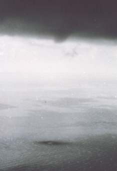
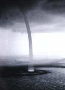
Stage 1: Dark Spot
State 4: Mature Waterspout
Stage 5: Decay
Forecasting Waterspouts on the Great Lakes
In 2006, Environment Canada meteorologists began an experimental forecast for waterspout formation using the Szilagyi Waterspout Index (SWI), which ranges from -10 to +10. When the index is zero or above, the likelihood for waterspout formation exists. The Index has arisen through years of research by Wade Szilagyi of Environment Canada into the conditions under which waterspouts form over the Great Lakes. He found the two main indicator parameters were the temperature difference between the water surface and the 850mb level and the convective cloud depth.
The forecast method is now an operational forecast tool for the Lakes. In the forecast output, positive values of the SWI is plotted on maps of the Lakes with the highest values being the most likely to experience waterspout formation.
August 19:Several waterspouts reported over Lake Ontario.
August 18: Nine waterspouts and several funnels seen over southern Lake Michigan in the morning.
August 17: Four waterspouts sighted in morning along a cold front over Lake Erie off Lorraine, Ohio.
August 9-12: A major waterspout outbreak occurred over the Great Lakes with over 35 waterspouts being sighted.
August 10: Two short-lived waterspouts developed over Lake Michigan 25 km (16 miles) north of Chicago�s Loop off Fort Sheridan.
July 27: Waterspout seen off of Milwaukee, Wisconsin, between 10:20 and 10:45 am, roughly 8 to 16 km (5 to 10 miles) off the coast, northeast of Bradford Beach.
July 27: A pair of waterspouts seen on Lake Michigan off Holland, Michigan.
The Great Waterspout Outbreak of 2003
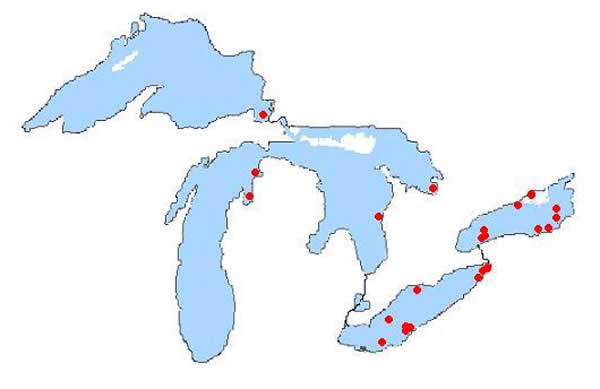
By far the greatest outbreak of waterspouts ever reported on the Great Lakes occurred from 27 September to 3 October 2003. According to an article on the outbreak in Mariners Weather Log by Wade Szilagyi, at least 66 waterspouts were observed with 21 occurring on a single day (2 October) over Lake Ontario. The outbreak brought the total number for the year 2003 to 82 sightings.
Waterspout outbreaks are common as they tend to occur in bunches, but this outbreak far surpassed others in the meteorological record. Its duration of seven days also made it the longest lasting outbreak event on record. Each of the five Great Lakes reported at least one waterspout.
Location of waterspout sightings during the outbreak (27 September - 3 October 2003). Note that some location points had multiple sightings.. From NOAA Mariners Weather Log, 2004
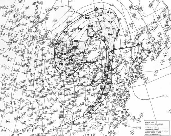
The event resulted from a cold air mass, with an associated upper trough, moving slowly over the Great Lakes. The usually warm lake surface temperatures were well above normal, due to a warmer than average summer.
(A similar me pattern had occurred in 2002 with water temperatures well above normal, but waterspout sightings during that year fell well below the average. Szilagyi believes the reason for the difference was that the main jet stream sat well to the north of the Great Lakes. As a result, few cold air outbreaks occurred that Autumn.)
The outbreak began when cold air flowed over the Lakes following a cold frontal passage on 27 September. For the week thereafter, no strong surface weather system crossed the Lakes. A high-pressure ridge in the lee of the Rocky Mountains provided the conduit for cold arctic air to rush across the Great Lakes basin. This combination established unstable weather conditions over the Lakes that were favorable for upward air movements.
Surface synoptic map. 1800 UTC 27 September 2003 From NOAA Mariners Weather Log, 2004
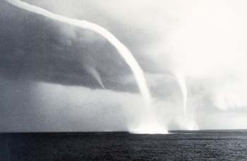
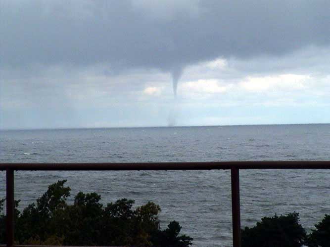
During the cold air outbreak, lines of horizontal convergence over the Lake waters became established which caused upward convective currents with associated showers and thundershowers. It was along such convergence lines that many waterspouts were observed. One line in particular produced a dozen waterspouts on 1 October, including a line of seven occurring simultaneously.
Photograph of one of the 21 waterspouts that formed along a convergent line over eastern Lake Ontario on 2 October 2003. Photo courtesy of L. Glover.. From NOAA Mariners Weather Log, 2004
Research forecasts for this outbreak gave four days lead time to the event based on information from the Canadian Global Weather Model. This was a major breakthrough in forecasting such events as a similar outbreak in 1996, which resulted in 41 waterspouts over six days had zero days lead.
A Busy Autumn 2012?
Does the early start to the Great Lakes waterspout season portend a busy year for waterspouts during the autumn months of 2012? Only time will tell, but conditions are ripe for their occurrence. The answer will depend in part to the timing and strength of cold air streaming across the warm waters.
Learn More From These Relevant Books Chosen by The Weather Doctor
Written by Keith C. Heidorn, PhD, THE WEATHER DOCTOR,
September 1, 2012 All images of waterspouts in this article courtesy NOAA Photo Library, NOAA Central Library, US Department of Commerce


 When the Great Lake waters heat over the summer, they retain a large portion of that heat into the autumn months. This heat is instrumental in the formation of lake-effect rain and snow as colder polar air descends across them during the autumn. The excess heat in the water also produces large temperature differences between the water and the overrunning cold air that induces convective currents to rise from the surface. Under the right conditions, these updrafts may form spinning vortices similar to dust devils on land. Such phenomena are known as waterspouts, and they differ from their marine counterpart only by the salinity of the water surface below.
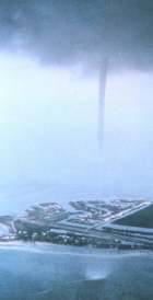 A true waterspout forms over the water and is not usually accompanied by a strong storm cell as is the tornadic waterspout. They commonly develop beneath lines of rapidly growing cumulus congestus clouds. These cloud lines can be quite shallow, averaging between 3600 and 430 metres (12,000 to 14,000 ft) deep with bases about 610 m (2000 ft) above the surface. The waterspout funnel forms in the rising air just ahead of any rainfall from these clouds in association with warm water temperatures and high humidity in the lowest kilometre of the atmosphere. Being small-scale circulation phenomena, waterspouts are not affected by the Coriolis force, and thus they have been observed to spin both anticlockwise (cyclonically) and clockwise (anti-cyclonically).