The Atlantic tropical storm season begins by convention on June 1st. Not that no tropical storms in the North Atlantic basin occur before this date, (as the 2012 season jumped the gun with Alberto in mid-May) but most storms fit into the period from 1 June to 30 November with a few outliers on either side. Most June tropical storms, however, are weaker than their late summer counterparts, in part because the ocean water temperatures over which they arise are still recovering from the winter chill.
However, in the 1957Atlantic hurricane season, the first named storm, Audrey, became the first and only June hurricane (of the modern record) to this day to reach Category 4 status on the Saffir-Simpson Scale. Even today, it is one of the three June hurricanes to make landfall on the continental United States. The storm came ashore across southwest Louisiana and southeast Texas during the early morning hours of 27 June 1957, taking many lives along the coastline. The death toll in the US from Audrey sits between 390 and 431, depending on the source. The storm then headed north and northeast, continuing its deadly rampage into Canada, taking lives in Ontario and Quebec in early July.
Early Days
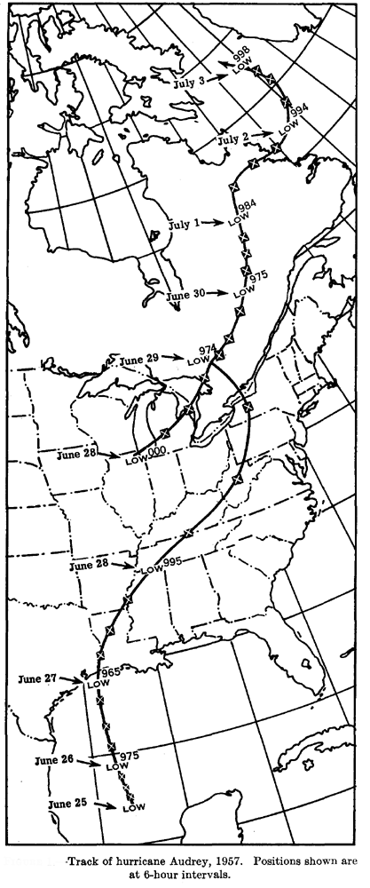
An upper-level easterly wave crossed the Caribbean Sea into the Gulf of Mexico during the period 20-25 June 1957. There in the Bay of Campeche, a tropical depression formed on 25 June sporting winds of 35-40 mph (56-64 km/h). The depression remained stationary and rapidly intensified in the warm Gulf waters, which were 2-3 F degrees (1.1 to 1.7 C degree) above normal for June. Navy aerial reconnaissance and a report from the SS Terrier soon showed that the depression intensified rapidly into a hurricane with maximum winds of 85 mph (136 km/h) and central pressure at 989 mb. Hurricane Audrey was born about 380 miles (612 km) southeast of Brownsville, Texas. The US Weather Bureau issued their first hurricane advisory of the year at 1800 GMT, 25 June.
As Audrey moved northward, its central winds increased to over 100 mph (Category 2). By 1200 GMT, 26 June, the storm’s center had moved to 250 miles (400 km) southeast of Brownsville and was picking up forward speed, heading toward the Texas-Louisiana coastline. That evening, the New Orleans Weather Bureau office issued the following Hurricane Warning and Advisory:
NEW ORLEANS WEATHER BUREAU
HURRICANE WARNING AND ADVISORY NUMBER 7 AUDREY
10 PM CST JUNE 26 1957
CHANGE TO HURRICANE WARNINGS 10 PM CST UPPER TEXAS COAST AS FAR SOUTH AS HIGH ISLAND. LOWER STORM WARNINGS EAST OF LOUISIANA TO PENSACOLA
AT 10 PM CST...0400Z...HURRICANE AUDREY WAS CENTERED ABOUT 235 MILES SOUTH OF LAKE CHARLES LOUISIANA NEAR LATITUDE 27.0 LONGITUDE 93.5 MOVING NORTHWARD ABOUT 10 MPH. THIS MOVEMENT IS EXPECTED TO CONTINUE AND THE AREA FROM HIGH ISLAND TO MORGAN CITY IS EXPECTED TO BEAR THE BRUNT OF THIS HURRICANE THURSDAY.
HIGHEST WINDS ARE ESTIMATED 100 MPH NEAR CENTER AND GALES EXTEND OUT 150 TO 200 MILES TO EAST AND NORTH OF CENTER AND 50 MILES TO THE SOUTHWEST.
TIDES ARE EXPECTED TO REACH 5 TO 9 FEET FROM HIGH ISLAND TEXAS TO MORGAN CITY LOUISIANA AND 3 TO 6 FEET ELSEWHERE FROM FREEPORT TEXAS TO BILOXI MISSISSIPPI BY LATE THURSDAY. ALL PERSONS IN LOW EXPOSED PLACES SHOULD MOVE TO HIGHER GROUND. WINDS ARE INCREASING ALONG THE UPPER TEXAS AND LOUISIANA COASTS AND WILL REACH GALE FORCE TONIGHT AND EARLY THURSDAY.
HURRICANE WARNINGS ARE DISPLAYED ALONG THE ENTIRE LOUISIANA COAST AND ON THE UPPER TEXAS COAST AS FAR SOUTH AS HIGH ISLAND AND STORM WARNINGS AT GALVESTON. THE THREAT OF HURRICANE FORCE WINDS OVER SOUTHEAST LOUISIANA HAS LESSENED CONSIDERABLY.
NEXT ADVISORY AT 4 AM CST BULLETIN AT 1 AM CST.
CONNER WEATHER BUREAU NEW ORLEANS
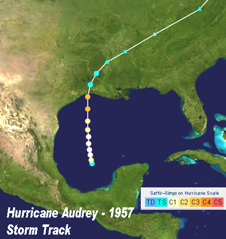
Hurricane Audrey Storm Track Image courtesy Wikipedia
By 1300 GMT (7 am CST) on the 27th, Audrey was centered off the Texas coast south of Port Arthur. Winds along the coast were reported at 75 mph (120 km/h) with a storm surge of 7 ft (2.1 m) hitting the Texas—Louisiana coast. But farther offshore, Audrey was flexing its muscle. Waves on the Gulf reached 50 ft (15.2 m) pushed by peak winds of 145 mph (233 km/h), Category 4 level. Just prior to landfall, the storm surge measured at least 6 ft (1.8 m) from Galveston, Texas to Cocodrie, Louisiana.
Landfall
Audrey made landfall on the US coast early in the morning of 27 June as a Category 4 hurricane along the east Texas—west Louisiana border, 23 miles (37 km) west of Cameron, Louisiana. Hurricane force winds extended from Port Arthur, Texas eastward to Mobile, Alabama. To the east of the eye, the peak winds at Lake Charles, Louisiana hit 105 mph (168 km/h). A similar reading was recorded at Sulphur, Louisiana before the anemometer blew away. Inland, in the path of the eye, Orange, Texas reported winds over 100 mph (160 km/h) before the eye passed over the town.
Impact of Hurricane Audrey along the Gulf Coast Image from The Hurricane Season of 1957 by Paul L Moore, et al. , Monthly Weather Review, Dec. 1957 Courtesy NOAA
The lowest barometric pressures measured at land stations were 958 mb at Hackberry, Louisiana, 959 mb at Cameron and 966 mb at Port Arthur. Prior to landfall, aerial reconnaissance recorded a central pressure of 946 mb.
The deadly storm surge from Audrey reached 12 ft (3.7 m) as it slammed into the coast. Most of the lives lost during the hurricane came as the surge pushed houses off their foundations and drove them far inland. The post-storm damage survey estimated 60-80 percent of the homes and businesses within a 22-mile (35 km) stretch from Cameron to Grand Chenier were destroyed or heavily damaged. The surge peaked at 10.6 ft (3.2 m) at Cameron around midday of the 27th.
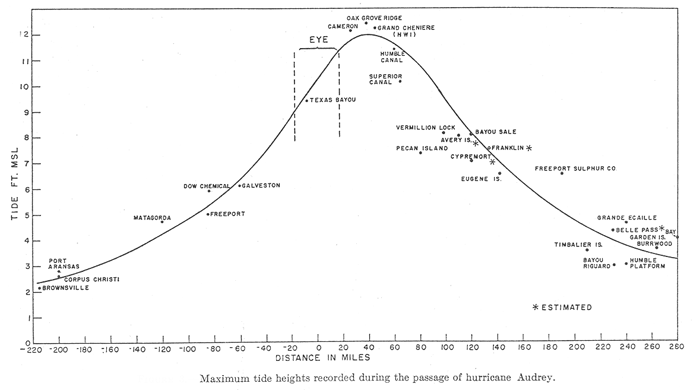
Storm Surge (tide height) from Hurricane Audrey along Gulf Coast Image from The Hurricane Season of 1957 by Paul L Moore, et al. , Monthly Weather Review, Dec. 1957 Courtesy NOAA
On the storm surge, the hurricane winds pushed waves 4 to 5 ft (1.2 – 1.5 m) on to the coast with peak waves estimated at 8-10 ft (2.4-3.0 m). With the coastline in Audrey’s path just above sea level and even below it, the high water pushed as far as 10 to 20 miles (16-32 km) inland. The surge and subsequent flooding from torrential rains covered 1.6 million acres ( 0.6 million hectares).
Audrey Weakens, Then Transforms
As the hurricane hit the coast, it began to weaken as it sped inland. By the morning of 28 June, the storm, centered over west central Tennessee, began to become extratropical. But its deadly rampage was not yet over.
In Alabama, Louisiana, and Mississippi, Audrey spawned 23 tornadoes that took at least two lives, injured many, and severely damaged property.
Audrey met with wave along the polar front near Chicago, Illinois and began its transition into an extratropical storm. The merger was complete within 24 hours.
As Audrey interacted with the front near the confluence of the Ohio and Mississippi Rivers, the combined conditions dropped a swath of rainfall from central Missouri across south central Illinois and Indiana that ranged from 5 inches (130 mm) to 11 inches (280 mm) in depth. Paris, Illinois recorded 10.2 inches (259 mm) of rainfall, which would pushed June and annual precipitation totals that year to record heights. Ten deaths were attributed to the subsequent flooding in the region.
The re-invigorated extratropical phase of Audrey brought strong winds and heavy rains to the eastern Ohio Valley and northeastern states before impacting Canada — southern Ontario and western Quebec — over the next few days. The extratropical phase of Audrey passed east of Buffalo, New York to lie in southwestern Quebec late on 29 June. With the storm’s central pressure dipping down to 974 mb, winds at Jamestown, New York reached 95-100 mph (152-160 km/h).
When the storm reached Ontario on the 29th, it sported winds of 58 mph (93 km/h) and heavy rains. Five people died: a boy drowned in ragging flood waters, and four adults died in car accidents attributable to the heavy rainfall. A number of others were stranded in cottage country and Algonquin Park by the waters. Another ten people died in Montreal, Quebec, nine in traffic mishaps.
Audrey’s final days saw it move northward through Quebec and northern Labrador and off the continent to finally die in the Davis Strait between Baffin Island and Greenland.
(Storm track map above from Hurricane Audrey 1957 by Robert B Ross and Maurice D Blum, Monthly Weather Review, June. 1957. Courtesy NOAA
In the Wake
In the wake of Hurricane Audrey, 431 people were dead in the US, most along the Louisiana coast, a number that could be pegged higher as many not included in the total remained missing. (Note that the National Oceanic and Atmospheric Administration (NOAA) tally sets the death toll at 390.) Much of the toll can be attributed to the speed at which the storm intensified and moved northward over the Gulf of Mexico to the coast. Storm warnings had initially put landfall a few days later than the actual event.
In the Gulf, Audrey damaged four oil-rig tenders that were driven aground, and it sank one mobile oil-drilling rig. Nine died when their boat sank during the blow. Ships in the vicinity of Corpus Christi, Texas were grounded. One home near Cameron was demolished by a ship the surge had pushed ashore. Ironically, its name was Audry.
Audrey’s massive storm surge crossed most of Cameron parish and the southern halves of Vermilion, Iberia, and St. Mary parishes, causing total devastation in property and many lives lost. Over 40,000 Louisiana residents were left homeless.
In Canada, the death toll was 15 with extensive damage due to the heavy rains.
Where Audrey stands in the ranking of deadliest hurricanes to hit the United States from 1900 to 1999 depends on which list of hurricane fatality totals one choses. The NOAA list published in 1996 rates Audrey as sixth based on 390 deaths, although the 431 total would move it to fifth. A list posted by Accuweather derived from the NOAA report The Deadliest, Costliest, and Most Intense United States Tropical Cyclones From 1851 to 2006 places Audrey seventh all-time and third during the 1900-1999 period with 416 attributed deaths. There is no controversy, however. when ranking Audrey as the deadliest hurricane to hit the United States from 1950 until Hurricane Katrina in 2005.
Audrey was the second strongest hurricane of 1957 trailing Category 4 Carrie, which formed in September, by 1 mb in lowest central pressure and 10 mph (16 km/h) in peak wind speed. However, Audrey remains (as of May 2012) the most intense hurricane to form during June in the Atlantic basin, and the earliest to reach Category 4.
The US damage costs from Audrey were pegged at $147 million in 1957, which exceeds $1 billion in today’s dollar.
Audrey was one of the earliest hurricanes to have its name retired — the eighth. It was also one of the few name to be retired on its first usage.
1957 Hurricane Audrey roars down Louisiana's Coast
Learn More From These Relevant Books Chosen by The Weather Doctor


 However, in the 1957Atlantic hurricane season, the first named storm, Audrey, became the first and only June hurricane (of the modern record) to this day to reach Category 4 status on the Saffir-Simpson Scale. Even today, it is one of the three June hurricanes to make landfall on the continental United States. The storm came ashore across southwest Louisiana and southeast Texas during the early morning hours of 27 June 1957, taking many lives along the coastline. The death toll in the US from Audrey sits between 390 and 431, depending on the source. The storm then headed north and northeast, continuing its deadly rampage into Canada, taking lives in Ontario and Quebec in early July.
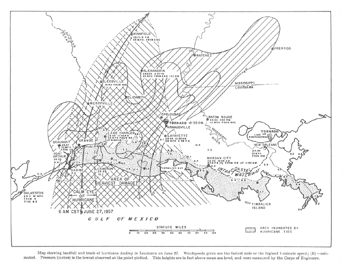
 As the hurricane hit the coast, it began to weaken as it sped inland. By the morning of 28 June, the storm, centered over west central Tennessee, began to become extratropical. But its deadly rampage was not yet over.
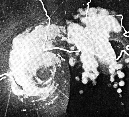 In the wake of Hurricane Audrey, 431 people were dead in the US, most along the Louisiana coast, a number that could be pegged higher as many not included in the total remained missing. (Note that the National Oceanic and Atmospheric Administration (NOAA) tally sets the death toll at 390.) Much of the toll can be attributed to the speed at which the storm intensified and moved northward over the Gulf of Mexico to the coast. Storm warnings had initially put landfall a few days later than the actual event.