| Home | Welcome | What's New | Site Map | Glossary | Weather Doctor Amazon Store | Book Store | Accolades | Email Us |
 | |||||||||
Weather Almanac for November 2011THE GREAT BLUE NORTHER OF 11/11/11November 11 (11/11) is a significant date in world history as it marks the date of the start of the Armistice of the First World War (the ceasefire was to start at 11:11 am). In Canada, we observe the date as Remembrance Day; in the United States, it is known now as Veteran’s Day, both in honor of fallen soldiers from all wars. (I believe as I was growing up in the US, the date was called Armistice Day, and we also marked VE and VJ days, the dates when the conflict of World War II ended in Europe and in the Pacific, respectively.) I am not a student of that conflict and have no idea why this interesting date and time were chosen, but 11-11 and 11-11-11:11 have interesting symmetries to numerologists. This year (2011), we will experience four unusual dates that recur once per century featuring the number 1: 1/1/11, 1/11/11, 11/1/11, 11/11/11. The last of these marks a centennial of interest to American weather historians as the date of one of the most dramatic Blue Northers and extreme temperature drops in US history.
For those more familiar with the metric system for temperatures, please forgive me for sticking with Fahrenheit in this essay, as it was the unit for the original measurements. With so many temperature values given in the text, my usual the inclusion of the Celsius equivalent made the text very hard to read. However, please note that when I speak of Fahrenheit degrees, I am referring to a temperature change ( indicated as F deg), not a temperature reading (denoted as °F) A temperature drop of 9 Fahrenheit degrees is equivalent to a drop of 5 Celsius degrees, and not -12 degrees Celsius. There have been many notable Blue Northers in American weather history and great temperature plunges, which I will mention at the end of this essay. The featured Blue Norther roared down the plains and crossed Missouri, Kansas, Oklahoma and Texas on 11 November 1911 accompanying a cold front, which brought record heat and cold and severe weather including tornados and blizzard conditions. It was not the most intense in American weather history, but certainly, it was a shock to those in its path, bringing record cold to locations that earlier had seen record heat. The storm associated with this cold blast also made headlines in the Midwest bringing cold and tornadoes. The Great Blue Norther of 1911A few days prior to the big temperature drop in the southern Plains, an arctic high pressure cell began slipping southward from Alberta dropping temperatures in Wyoming, Montana and the Dakotas by 20 to 30 F degrees. Low temperatures on the morning of 9 November in this area had plummeted to under 10°F. Helena, Montana had fallen to -4°F while Havre was down to -2°F. Williston, North Dakota sat at 0°F. As the cold air passed Rapid City, South Dakota on the 9th, the temperature plunged from 55°F to 3°F. (For residents of Rapid City, this would be the second rapid temperature drop of more than 40 F deg in 1911. On 10 January, the mercury fell 47 F deg in less than an hour. Then again on the 12 January, they experienced a drop of 36 F deg in two hours.) At the same time, a Colorado low began taking shape in western Colorado, and a southwesterly current of air from the Southwest desert flowed into the southern Plains. The high temperature reached 76°F at Oklahoma City, Oklahoma and 82°F at Fort Worth, Texas. 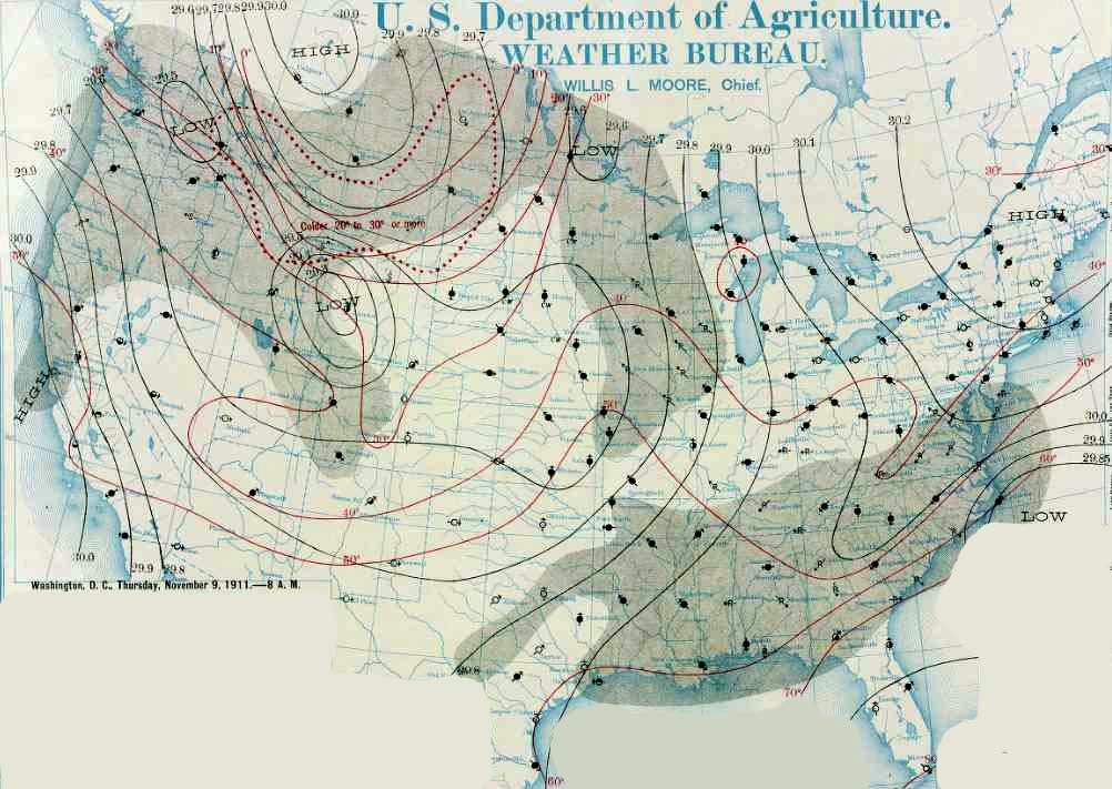 Weather Map for 9 November 1911 (8am EST)On the morning of the 10th, the low remained in Colorado while the high slipped a little further south bringing sharp temperature drops to the Dakotas, Minnesota, eastern Nebraska and northern Iowa. The southern plains continued to warm with highs 80°F or above at Oklahoma City and Fort Worth. The temperature contrast across the Plains was as much as 90 F deg, as Havre and Helena struggled to reach a high of -4°F. Lows below 0°F were common in North Dakota, Montana and Wyoming. 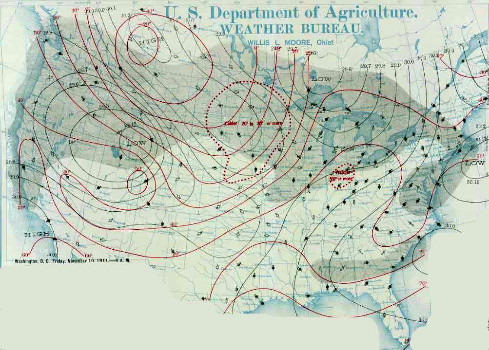 Weather Map for 10 November 1911 (8am EST)On the morning of the 11th (at 7 am Central Standard Time (CST)), a long trough of low pressure with two low pressure centers — one over central Wisconsin, the other over northwestern Missouri —stretched from Lake Superior to northeastern New Mexico. Although weather fronts were not yet drawn on weather maps, it is easy to see from the wind and temperature fields that a cold front stretched from around La Crosse, Wisconsin southwestward through Topeka and Dodge City, Kansas to north of Amarillo, Texas. In parts of Missouri, Kansas, Oklahoma and north Texas, this morning was very mild for mid November, and daily high temperature records were to be set this day at Oklahoma City (83°F); Independence, Kansas (83°F); Springfield, Missouri (80°F); and Kansas City, Missouri (76°F). Though not records, Ft Worth, Texas reached 86°F; Keokuk, Iowa, 78°F; St Louis, Missouri (78°F); and Amarillo, Texas (70°F). In contrast, the day’s maximum temperatures in Helena (-2°F); Valentine, Nebraska (0°F); Williston and Bismark, North Dakota (0°F); Rapid City, South Dakota (0°F); Pierre, South Dakota (2°F) and Moorhead, Minnesota (8°F) failed to reach 10°F. The tightness of the horizontal thermal gradient is evident by the 68°F temperature reading at Kansas City while less than 400 miles way at North Platte, Nebraska, the mercury stood at only 4°F. The Big PlungeAs the cold front passed, temperatures plummeted. In Kansas City, Missouri, the balmy (76°F) Saturday morning turned inky black on the northwestern horizon, and shortly after the noon hour, snow began to fall. The temperature went into free fall and hit 11°F by midnight and 6°F by the following morning. Farther east, Springfield, Missouri remained warm until mid afternoon when gusty northwest winds reaching 74 mph began a temperature plunge from the record high of 80°F to 40°F in an hour. The Springfield weatherman-in-charge John S. Hazen noted, “Hail, sleet, rain, and snow fell. First thunder at 4:52 p.m. Last 6:10 p.m.” The temperature dive continued passing 20°F at 7 pm and 13°F at midnight. The temperature drop bottomed at 8°F Sunday morning. The day’s high and low temperatures would both set daily records in these Missouri cities. And although Oklahoma City’s plunge is the one most remembered, the drop in Springfield from 80°F to 13°F — 67 F deg — is one F degree greater than that experienced at Oklahoma City. The difference between the Saturday high and Sunday low, measures 72 F deg, which exceeded that in Oklahoma City as well. 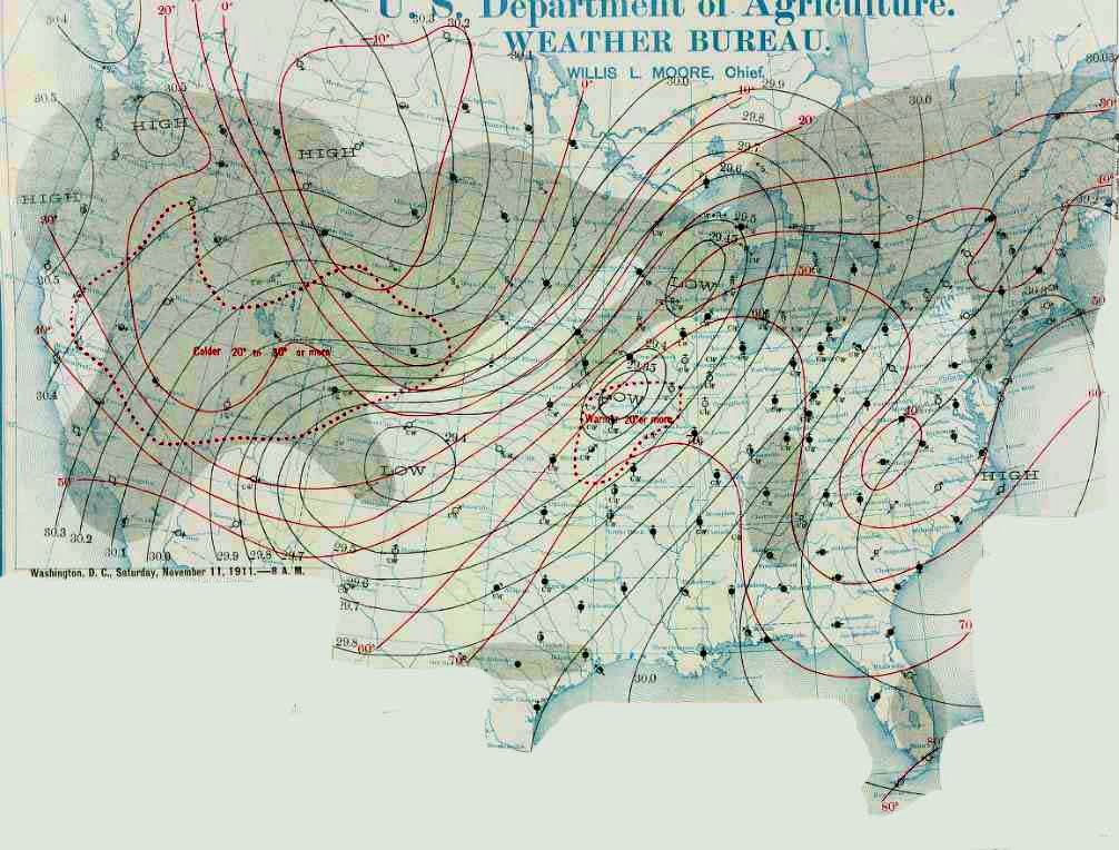 Weather Map for 11 November 1911 (8am EST)In St Louis, the temperature plunged from 79°F at 1 pm to 34°F at 8 pm and 22°F at midnight. At one point, the local Post-Dispatch newspaper reported, the mercury fell 26 F deg in 10 minutes. The following day, a blizzard swept the city according to news reports as the temperature bottomed out at 12°F, a differential of 67 F deg. Oklahoma City was the next major city to feel the Great Blue Norther. There the warmth lasted until mid-afternoon, reaching a record high of 82°F at 1 pm. By midnight, the thermometer read a record low for the day of 17°F and continued to fall to 14°F Sunday morning. The temperature drop showed a fall of 66 F deg on the 11th and 69F deg between the high on the 11th and low on the 12th. As with the two Missouri cities, the day’s high and low were both Oklahoma City records. Interestingly, as of this writing (October 2011), both those Oklahoma City marks still stand. While these four cities are featured herein, they are not the only ones to see major temperature drops. If we look at the temperature differences between the Saturday high (11th) and Sunday low (12th), Keokuk, Iowa fell 66 F deg; Davenport, Iowa, St Joseph, Missouri, and Springfield, Illinois plummeted 64 F deg; Dubuque, Iowa plunged 60 F deg; Chicago, Illinois and Wichita, Kansas chilled 58 F deg; and Madison, Wisconsin dropped 56 F deg. We also find Forth Worth and Abilene, Texas with a 66 F deg plunge, and Amarillo, Texas with a 60 F deg drop. In Independence, Kansas, the temperature sank from 83°F to 33°F in one hour. Extreme weather guru Christopher Burt has commented that “never before or since in the United States’ climate record have so many states recorded both their extreme monthly heat and cold records within a 24 to 36-hour period.” While many other communities saw record highs, lows and plunges, many states recorded high--low temperature spreads across their territories that exceeded 80 F degrees over a 24-36 hour period. These include Oklahoma, 92 F deg; Kansas and Ohio, 88 F deg; Iowa, 87 F deg; Missouri, 82 F deg; and Arkansas, 81 F deg. (The high temperature reported at Gano, Missouri on the 11th was reported at 93°F, but it is suspect. However, if correct, the temperature range for Missouri would be 96 F degrees.) Temperature differentials before and after the cold frontal passage of over 90 F deg occurred in Minnesota (91 F deg) from 11 to 16 November and in Michigan (90 F deg) from 9 to15 November. Tornadoes Too
The first significant tornado to set down on that infamous day did so minutes before 1 pm local time west of Davenport, Iowa in Scott County. The storm struck five farms, damaging buildings and injuring one person. Several hours later, a tornado set down in Cass County, Illinois near Arenzville and raced the ten miles to the town of Virginia where the storm damaged about 30 homes and businesses, severely damaged the hotel and high school, and destroyed one church. A dozen injuries resulted. The first fatalities of the day resulted when a tornado moved across Mason County, Illinois near Easton at around 4:45 pm. An elderly woman and an infant died, and nine others were injured. The next twister to strike Illinois did so at 5:30 pm in Dupage County moving from east of Aurora to northeast of Naperville. One home was unroofed and northeast of Aurora, a large grove of trees was smashed. The tornado moving across Lake and Porter Counties, Indiana struck after dark (around 8 pm) moving from near Leroy to west of Valparaiso and then lifted before it reached Michigan City. Two schools were destroyed as well as fifteen farm buildings. One local recalled increasing storminess as he went to bed. The next thing he remembers was finding himself regaining consciousness in a neighbor’s home. The Janesville, Wisconsin tornado preceded blizzard conditions, striking at 9 pm local time. Dozens of businesses and homes were destroyed as the storm moved through the town and then on to nearby Milton. Damage estimates reached $500,000 and the storm killed nine and injured another 50. The first responders on the scene of the devastation that evening found themselves in a blinding snowstorm with frigid temperatures. At 10 pm local time, an F2 tornado moved across Calhoun County, Michigan. It leveled barns and unroofed homes southeast of Battle Creek. This storm may have been accompanied by a second tornado that killed horses and cattle in nearby Eaton County. At 11 pm, the next tornado in the outbreak struck Waterloo, in De Kalb County, Indiana. According to the Fort Wayne Journal Gazette, the warm evening caused local residences to leave their windows open to the sultry air. Then suddenly, a tornado descended on Waterloo and began a three-minute rampage through the town. The fierce winds destroyed the local opera house, two schools, the fire hall and the post office, causing over $100,000 in damages. The tornado flipped a train from its tracks then moved outside the town limits. There the winds destroyed homes and barns including one home whose walls were lifted away and deposited in a nearby field, leaving a family of six bewildered in their beds. Incredibly, there were no reports of injuries or deaths. However, residents of Waterloo had to face the damage the next day with sleet, ice and snow descending on them. The last tornado that day, and the last significant tornado of 1911, struck the Michigan community of Owosso just after 11 pm EST. Two died and 21 received injuries as the twister destroyed at least five factories including the Estey furniture factory. The two deaths were of a couple whom the storm caught in bed as it ripped the upper story of their home off. Miraculously, another couple asleep downstairs was uninjured. Three local churches lost their steeples to the fierce storm. In addition to the tornadoes, the storm kicked up a dust storm in Oklahoma and sent a blizzard through Ohio. 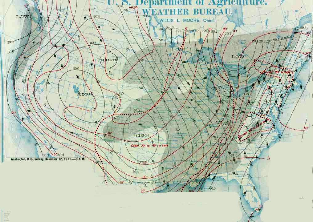 Weather Map for 12 November 1911 (8am EST)By the morning of the 12th, the arctic high had slipped southward into Oklahoma and the trough was now a consolidated low north of Lake Huron in Ontario. Strong northerly winds blew across the United States from Montana east to Michigan and southward into Texas. The cold front stretched from the eastern Lake Erie basin southwestward to north of New Orleans and into the Gulf waters off Texas. The pocket of warmest air ahead of the front covered much of Virginia and North Carolina. As the cold front moved off the Atlantic Seaboard and the core of the cold high slipped into the lower Mississippi Valley on the 13th, temperatures dropped significantly in the eastern states. The largest temperature drops from the highs registered on the 12th to the lows of the morning of the 13th occurred at: Asheville, North Carolina, 54 F deg; Northfield, Vermont and Washington DC, 48 F deg; Augusta, Georgia, Savannah, Georgia, Raleigh, North Carolina, and Richmond, Virginia, 46 F deg; New York City, New York and Norfolk, Virginia, 44 F deg; Philadelphia, Pennsylvania, 42 F deg. 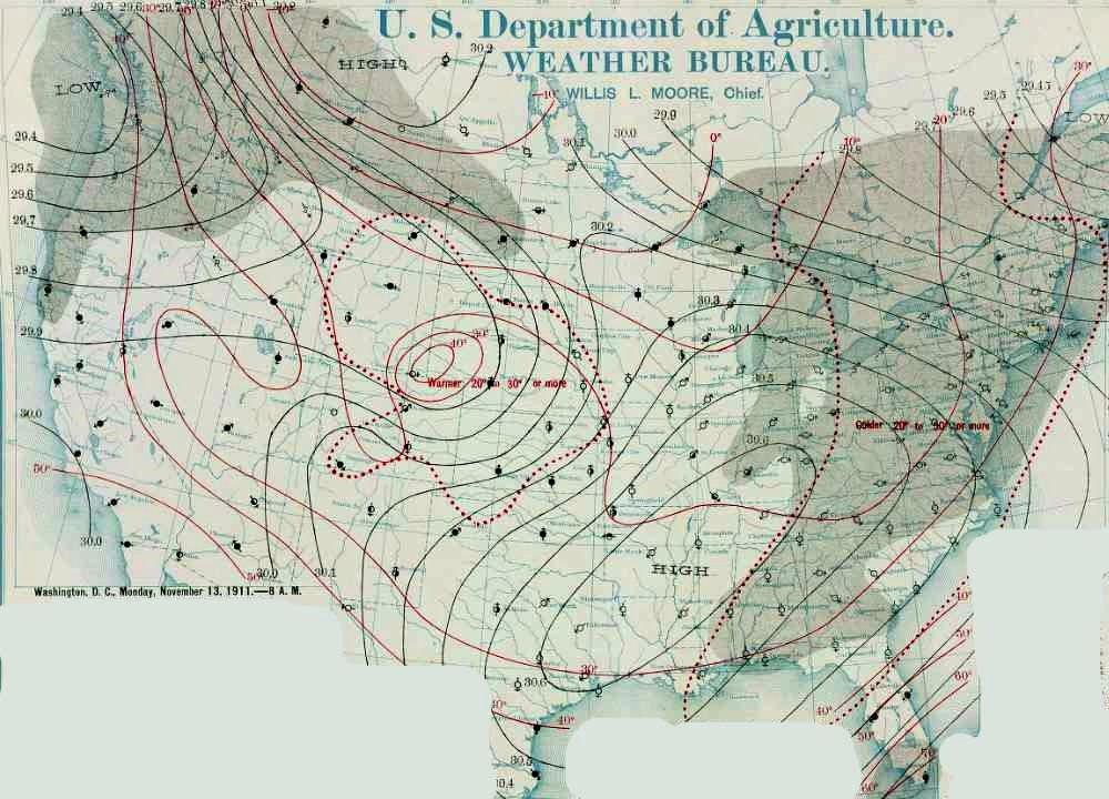 Weather Map for 13 November 1911 (8am EST)As the high slipped off the coast, temperatures in its wake again warmed. Many locations saw daily temperature increases of 20 F deg or more as the warm southerly flow on the back of the high sent more seasonal temperatures across the land. Other Great Temperature Drops in the United StatesThe largest temperature plunge ever recorded in the United States happened at Browning, Montana: In a 24 hour period over 23 to 24 January 1916, the temperature dropped 100 Fahrenheit degrees from 44°F above zero to minus 56°F.
At Rapid City, South Dakota the morning of 10 January 1911 saw the temperature drop from 55°F at 7 am to 8°F at 7:15 am — a 47 F deg temperature drop in 15 minutes. Two days later (12 January), the scene was repeated when the temperature fell 62 F deg from 49°F at 6 am. to -13°F at 8 am. On the same day, the temperature in Chicago, Illinois plummeted 62 F deg. On 12 February 1899, Waco, Texas saw its mercury sink 30 F deg in one hour. On Christmas Eve 1924, Fairfield, Montana witnessed a temperature plunge from 63°F at noon to minus 21°F at midnight, an 84 F deg difference. At Huron, South Dakota, the mercury fell on 17 March 1883 from 71°F to -8°F the following day. Another extreme temperature plunge due to a Blue Norther occurred at Amarillo, Texas on Friday 12 December 1919. At noon, the temperature stood at 67°F. an hour later, the temperature had fallen an astounding 44 F deg to 23°F. The descent continued, and at 7 pm, the temperature had fallen to 1°F, 66 F deg below the high temperature 7 hours earlier. Learn More From These Relevant Books
|
|||||||||
 |
Now AvailableThe Field Guide to Natural Phenomena: |
Now Available! Order Today! | |
 |
 |
Now |
The BC Weather Book: |


 Blue Norther is one of the colorful names given to extremely cold winds blowing down from the north across the American Plains. The Barber and the Arctic Screamer are other terms for these frigid winds. Blue Northers are strong winds and generally bring quick temperature drops of 25 Fahrenheit degrees (F deg) or more in an hour or 50 F deg over a few hours.
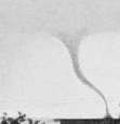 It is not a surprise to those knowledgeable of American weather to consider that such a weather scenario would produce severe local storms when such a strong cold front passed. Indeed, back analysis has indicated that the low-pressure system likely had an accompanying stream of dry air, which set up atmospheric conditions ripe for tornado development. Through the day of 11 November, tornadoes roared across the landscape in Iowa, Michigan, Illinois, Wisconsin and Indiana. The most intense was an F4 storm in Janesville, Wisconsin, and F3 twisters struck near Leroy, Indiana and Easton, Illinois. F2 tornadoes hit near Davenport, Iowa, Aurora, Illinois, Virginia, Illinois, Battle Creek, Michigan, Waterloo, Indiana and Owosso, Michigan.
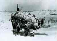 A Blue Norther that pushed through the Texas High Plains in 1933 caused the temperature on 6 February to drop from a high of 69°F to a low of -6°F, a 75 F deg differential.