Summertime in the Canadian Rockies is a great time for cloud watching as the ascending moist currents along the surrounding ridges build shapely clouds, particularly those of the cumulus family. As I sat watching the evening colors play on the clouds and peaks to the east yesterday, I wondered if this year will again reveal a noctilucent cloudscape to me. I also began thinking of those cloud forms I have not yet written about here on The Weather Doctor, Three came to mind.
The first is a rather rare form related to the noctilucent clouds that also occurs high in the atmosphere: the nacreous cloud. The second is an unusual form not well known in North America, but is famous in Northern Australia: the Morning Glory. The third of my cloud trio is a cloud type that is “new,” that is, there is a push to give it an official designation as a cloud subtype. This cloud is called asperatus, or more correctly Undulatus asperatus.
Nacreous Cloud
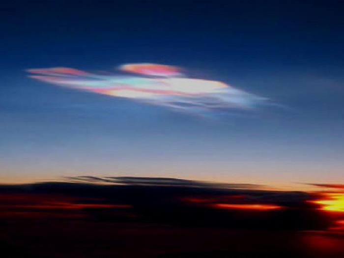
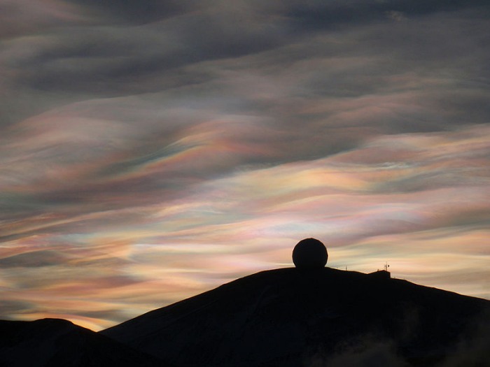
Nacreous clouds, also known as mother-of-pearl clouds and polar stratospheric clouds, are not the run-of-the-mill clouds for two important characteristics. First, they are often composed of crystalline nitric and/or sulfuric acid in addition to water ice. Second, they form only in winter and do so high in the stratosphere when temperatures drop to below minus 78 oC (-108 oF). Because they are rare, we do not know much about them except they fit into the grouping of polar stratospheric clouds (PSC) that have been linked with ozone destruction in the polar regions. [Nacreous cloud photo to right, courtesy Space Research Institute (Russia).]
Their alternate name mother-of-pearl cloud indicates nacreous clouds exhibit vivid colorations. Like noctilucent clouds, they usually only become visible for a few hours before sunrise or after sunset. Their extreme height allows the sun to illuminate these tenuous clouds from below the horizon, thus allowing their delicate beauty to shine brilliantly against the dark twilight sky. They appear as filmy sheets that shift their colors as the crystals move in the fading sunlight. The sheets themselves may change shape, stretching and contracting, curling and uncurling slowly in the fading light.
Nacreous Clouds over the NASA Radome, McMurdo Station, Antarctica Photo by Alan Light via Wikipedia.
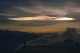
The components of nacreous clouds can be purely water crystals if the temperatures under which they form is below minus 85 oC (-120 oF). At these temperatures, the clouds are classified as Type II polar stratospheric clouds. These are believed to be the more spectacular form of PSC. Type I PSCs, which may form at temperatures as warm as minus 78 oC (-108 oF), contain nitrogen and/or sulfur acids as well as water. Their crystals form from nitric and sulfuric acids attached loosely to water molecules to produce hydrates such as nitric acid trihydrate (HNO3-3H2O).
Nacreous Clouds (PSC type II) over the NASA Radome, McMurdo Station, Antarctica Photo courtesy NASA.
The cold temperatures required for their formation means the clouds usually arise in the polar stratosphere during the winter. As a consequence, skywatchers most likely to observe nacreous clouds reside in Scandinavia, Arctic Russia, Iceland, Alaska and Arctic Canada, and to the researchers in the Antarctic. However, on the rare occasion, nacreous clouds have appeared in the high mid-latitudes. One notable display in February 1996 astonished skywatchers in Great Britain and Ireland as far south as London and Cambridge.
They say the beauty of nacreous clouds resemble mother-of-pearl or the inside of an abalone shell. A somewhat similar sky phenomenon would be the irisation or iridescence that can occur in altocumuli or cirrocumuli. I unfortunately have never viewed nacreous clouds, but since I live on the edge of their realm, I am hopeful that one day I will see a display.
A set of stunning photos of nacreous clouds can be found on Spaceweather.
The Morning Glory
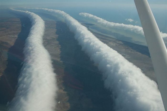
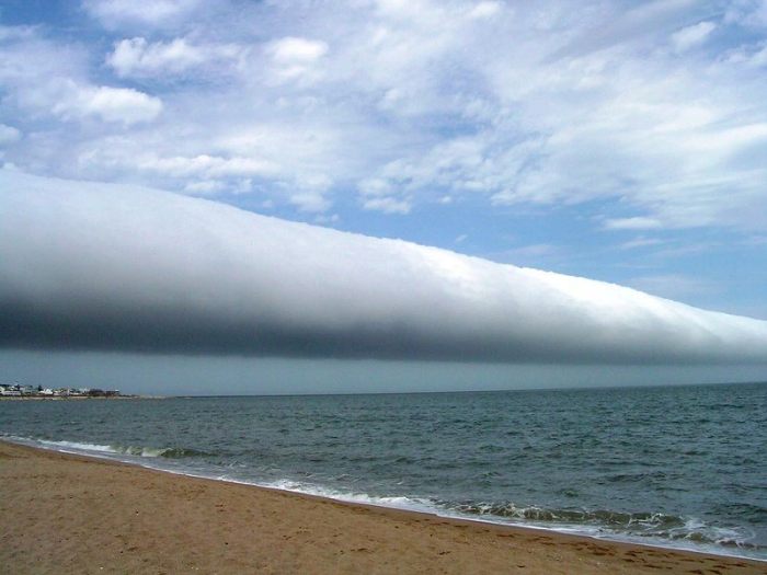
The Morning Glory, defined in the context of clouds, usually refers to a large, spectacular display of roll clouds that fill the skies near the Queensland, Australia town of Burketown. This particular display has been named the “Morning Glory” for its glorious appearance in the morning light. The Morning Glory regularly appears each September and October (late austral spring) over Northeast Australia’s York Peninsula in the early morning hours. The wind field associated with the Glory provides ideal soaring conditions for glider pilots who flock to the area at this time.
Photo of a Morning Glory cloud formation taken from the air near Burketown Queensland, Australia. Photo courtesy Mick Petroff
The size of the Morning Glory can be astonishing as well. The cloud tube may stretch over 960 km (600 miles) and rise to 300 m (around 10,000 feet). As the cloud “rolls” across the region at speeds of as much as 60 km/h (38 mph), sudden wind squalls and intense wind shears are present. Ahead of the cloud, strong updrafts draw the air upward where it condenses to form the cloud body. Behind, the air sinks, causing a pressure spike on the ground. The combination of rising and sinking currents give the impression that the cloud is rolling. However, it actually moves forward like a tidal bore or a soliton, a solitary wave with a single crest that advances without changing form or speed.
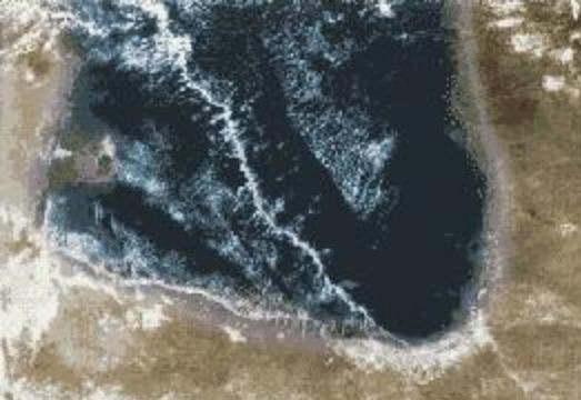
Satellite Image of the Morning Glory cloud pattern over Queensland Australia. Courtesy NASA
Years of research have allowed meteorologists to produce an acceptable explanation for the formation process of the Morning Glory. They develop when two air masses of differing temperatures come together. In the collision, the warmer air rises, and the colder air replaces it at lower altitudes, much like at a weak cold front or sea-breeze front. Overnight, a cool layer will develop at the surface, allowing the colder air to quickly advance. This produces a “bump” along the colder air mass’s boundary. By morning, this bump has become well established and advances through the warm air like a single wave, producing a strong updraft as it undercuts the warm air. When sufficient moisture is present in the rising air, it condenses, generating a visible cloud. (It is possible for the circulation to develop and not form a cloud. This has happened in Oklahoma.)
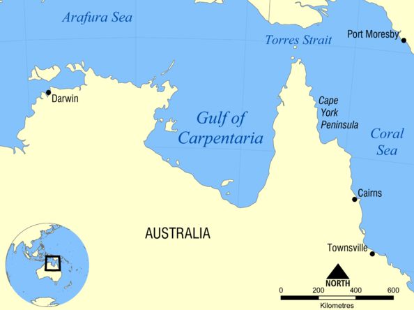
Australia's Cape York Peninsula separates the Gulf of Carpenteria from the Coral Sea and sea breezes form along both coasts ,advancing inland to meet over the peninsula. Where they meet, a convergence line of rising air begins the process of Morning Glory formation. Local lore in Burketown predicts that when fridges frost over and the table corners turn upward in the Burketown Pub, a Glory will form.
Map showing the York Peninsula in northern Australia. Nearby bodies of water including the Arafura Sea, the Coral Sea, and the Gulf of Carpentaria. Map courtesy Wikipedia
Once thought unique to northeastern Australia, the glory cloud is now known to occur over land and sea in many other regions of the world including other areas of Australia, Germany, Russia; Lithuania; the Shetland Islands and England; Qatar; Brazil and Uruguay; the Mexican Coast by the Sea of Cortez; Canada’s Sable Island, in the Canadian Provinces of Ontario and Nova Scotia; and in the United States in California, Oklahoma, and the Carolinas. However, only in Queensland do they appear predictably and regularly. The passage of an invisible glory circulation structure was observed in Oklahoma by the state’s mesoscale observation network MESONET.
Roll Cloud seen over Las Olas Beach located at Punta del Este, Uruguay on 25 January 2009. Photo courtesy of Daniela Mirner Eberl.
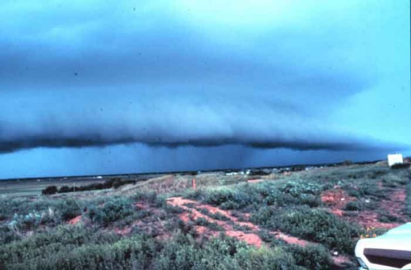
The Morning Glory is considered a special form of roll cloud. The roll clouds share with shelf clouds the designation of arcus clouds. Arcus clouds generally appear as long, low clouds and are often associated with thunderstorms, particularly the shelf cloud which forms on the downdraft at the storm’s gust front. Roll clouds, however, are completely detached from the thunderstorm and may form away from any storm or synoptic front.
Shelf cloud formation arising on a thunderstorm downdraft. Picture Courtesy of NOAA Photo Library
Asperatus, A New Cloud Type?
More than half a century has passed since the World Meteorological Organization has added a new cloud type to The International Cloud Atlas when it designated cirrus intortus in 1951 as a new variety. (The International Cloud Atlas currently recognizes four main cloud types and 80 varieties.) But in 2009, a campaign, led by the Cloud Appreciation Society with support by the Royal Meteorological Society, began to add another: Undulatus asperatus.
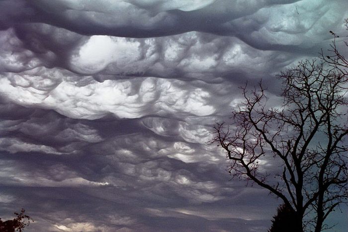
Clouds over Pocahontas, Missouri in asperatus formation
Photo courtesy of Agathman via Wikipedia.
The Cloud Appreciation Society petitioned: “We propose that asperatus should be adopted as a new 'variety' of cloud, meaning that it is a particular characteristic that appears in one or other of the main cloud types. This would mean that the rough and choppy looking Altocumulus cloud shown here would become known as 'Altocumulus asperatus.'”
Actually, what the society proposes is not a radically different new cloud form to join stratus, cumulus, and cirrus, but a new variety or species, in the terminology of the Atlas. In the Linnaean scheme, it would be in the Family Low Cloud, Species Undulatus or perhaps Altocumulus, and Variety asperatus.
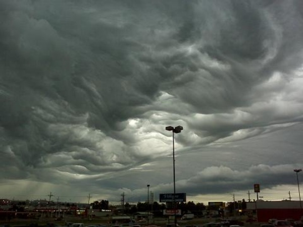
Undulatus asperatus Photo courtesy of Tony Dustman.
Undulatus asperatus, or in short form asperatus (Latin for “roughened up”), forms below 2000 m (6600 ft) and has a wavy underside. The cloud is both ominous and fascinating in appearance. These clouds look similar to an inverted, choppy sea surface and are a very turbulent, violent, chaotic form of undulation. (When first describing this cloud, Cloud Appreciation Society founder Gavin Pretor-Pinney called it “the Jacques Cousteau cloud,” for its similarity to a roiling ocean surface.) The formal name for the cloud, “asperatus” has precedents in literature as Classical poets used the term to describe seas being agitated by strong winds.
Initial climate information suggests they are most common in the US Plains states, often in the morning or midday following convective thunderstorm activity.
Currently, no definitive process has been associated with their formation, but they appear to arise, according to Jesse Farrell of Accuweather’s Weathermatrix blog, when very moist air flows into very dry air. The British Royal Meteorological Society is currently undertaking a study to determine the conditions under which asperatus forms.
Final Thought
Old or new, rare or common, clouds provide many hours of enjoyment, whether painting them, photographing them or just watching. While the three clouds described above can be considered rather rare, except in Queensland in spring, the hopes of viewing one ranks high in the thrill of the chase, much as a birder looks for the rare warbler. Perhaps I have already seen asperatus and a roll cloud but did not recognize it. Either way, I keep my eyes to the sky.
Learn More From These Relevant Books Chosen by The Weather Doctor


 Nacreous clouds, also known as mother-of-pearl clouds and polar stratospheric clouds, are not the run-of-the-mill clouds for two important characteristics. First, they are often composed of crystalline nitric and/or sulfuric acid in addition to water ice. Second, they form only in winter and do so high in the stratosphere when temperatures drop to below minus 78 oC (-108 oF). Because they are rare, we do not know much about them except they fit into the grouping of polar stratospheric clouds (PSC) that have been linked with ozone destruction in the polar regions. [Nacreous cloud photo to right, courtesy Space Research Institute (Russia).]