Weather Almanac for April 2011
2011 Spring Flooding
in the Mississippi and Red River (North) Valleys

As the flooding continues into the late spring of 2011, I have moved the story of floods on the Mississippi River system and the Red River of the North system to a separate page. Here is the chronology of this event as it unfolds.
2011 Flooding Fears
As of late March 2011, flood forecasters with the US National Weather Service (NWS) were warning of “potentially catastrophic flooding” (95% chance) beginning in April over nearly half the United States, and particularly down the Mississippi Valley from its headwaters to New Orleans. Several major metropolitan areas sit in the upper Mississippi basin from Minneapolis/St Paul, Minnesota to St Louis, Missouri. In addition, cities where flooding is feared along the Red River (also known as the Red River of the North in the US) include Grand Forks, Fargo and Sioux Falls in North Dakota, and Winnipeg in Manitoba.
In Manitoba, the Manitoba Water Stewardship also anticipates severe flooding this spring along the Red, Souris, Pembina, Assiniboine, Winnipeg, Saskatchewan and Fisher Rivers that could reach record water levels. At the time of this writing, the flooding was expected to be of similar size to that in 2009 but could reach the levels of 1997, particularly if late Spring precipitation is heavy. Current Environment Canada long-range forecasts called for a wetter than normal April-May-June for Central Manitoba. The US Climate Prediction Center for the same period also foresaw above normal precipitation for North Dakota and northwestern Minnesota.
The reason for the concern began with heavy late summer and autumn precipitation in 2010 where twice the normal amount fell in parts of North Dakota and Minnesota. That left soils saturated and streams running high before the winter freeze-up. The winter snowfall was also heavier than normal, and temperatures continued below freezing over most of the winter, which allowed the snowpack to remain deep in many areas of North Dakota, northern Minnesota and northern Wisconsin. In places, the depth of waterlogged snow on the ground in mid-March measured 1 to 3 feet (30-90 cm). Typically, snowfalls in this area are dry and powdery and have a low water content. But the 2010-11 season’s snowpack held a water equivalent of 1 to 6 inches (2.5-15 cm), which ranked among the highest moisture contents of the last 60 years for the region. At Fargo, North Dakota, however, the water content was nearly twice that normally expected at this time of the year.
The NOAA forecasters consider the flood threat immanent, along the Red River, which forms the state line between eastern North Dakota and northwest Minnesota; the Milk River in eastern Montana; the James and Big Sioux Rivers in South Dakota; and the Minnesota River. Excluding the Red River, all these drain rivers into the upper Mississippi River basin. The danger will increase if any large spring storms bring heavy rains or more snow to the area. The long-range weather forecasts issued by the US Climate Prediction Center predicts above normal precipitation for the Dakotas during April/May/June. If this forecast is manifest, flooding will be more severe and prolonged.
The National Hydrologic Assessment, a report issued each spring by the NWS, provides an outlook on US Spring flood potential. Its assessment for the Lower Mississippi River in Spring 2011 warns: “This spring, as flood waters drain from the Upper and Middle Mississippi and Ohio Rivers, the flood threat downstream to the Gulf of Mexico will increase. Despite dry conditions through much of the Gulf Coast over the winter, the Lower Mississippi River now has an above average risk of flooding. Recent snowmelt and rains across the Ohio, Cumberland and Tennessee Rivers are currently producing moderate to major flooding on the Lower Ohio River and Mississippi River above Memphis, TN.”
The map below shows the initial Significant River Flood Outlook as reported by the US National Weather Service.
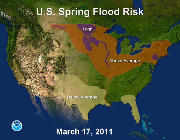 Courtesy US National Weather Service (NWS)And the unprecedented snowpack continued to accumulate in the upper drainage basins of these rivers as heavy snows fell in the last ten days of March, particularly across the Dakotas and Minnesota to Wisconsin. In Minnesota, hydrologists expect the Mississippi River to hit record levels. Near St. Paul, the river was expected to crest before the month’s end.
Red River (of the North) Valley Flooding
During early April 2011, flooding began on the Red River system from North Dakota/Minnesota into Manitoba.
7 April 2011: On 7 April, the Red River at Fargo, North Dakota had risen to 31 ft (9.5 m) The stage that Wednesday morning showed that advance preparations spurred by early forecasts of spring flooding were warranted. The previous morning, National Weather Service hydrologists had forecasted a crest of 39.5 feet, just shy of record levels (40.84 feet on March 28, 2009) at Fargo late that week.
9 April 2011: In Manitoba, officials opened the Red River Floodway, a canal that diverts water around the city of Winnipeg. While flood forecasters in Manitoba are now downgrading the severity of flood potential later in April or early May, a large portion of the province is being affected by rising waters along the Red, Lee, Assiniboine, Roseau, Morris, Pembina, Souris, Qu'Appelle, Oak, Little Saskatchewan, Whitemud, Fisher, Icelandic, Vermilion and Saskatchewan Rivers.
10 April 2011: The Red River crested in Fargo and Morrhead, Minnesota across the riverat near 40 ft (12.2 m) with some flooding occurring in the region. While the flood potential was diminishing in the US, waters were still rising north of the border in Mantoba, Canada. As a consequence, the City of Winnipeg called for 900 sandbaggers to hrlp shore up dikes and protect homes within the city.
12 April 2011: As of 12 April, Manitoba highway officials had closed 55 highways in the province due to flooding. Both St Andrews and Brandon, Manitoba have declared a state of emergency as did Riverton, a community north of Winnipeg, where an ice jam has caused local flooding. Around 400 residents have been evacuated from flood-affected areas of Manitoba so far. The first fatality attributed to the flood was reported by local officials when a man from Lac du Bonnet, Manitoba died after his car rolled into a flooded ditch near the Lee River in eastern Manitoba.
The forecast for the Red River Valley in Manitoba now foresaw flooding to peak in the latter weeks of April or first week in May at around 6.1 to 6.7 m (20-22 ft) above normal winter ice level. At the high end of this estimate, waters would be lower than previously forecast but still above the crest reached in the devastating 2009 spring flooding. At this date, flooding was occurring or expected to occur on the Red, Assiniboine, Roseau, Morris, Pembina, Souris, Qu'Appelle, Oak, Little Saskatchewan, Whitemud, Fisher, Icelandic, Vermilion and Saskatchewan Rivers.
14 April 2011: The Red River crested at Grand Forks, North Dakota at 15.15 metres (49.67 ft), making it the third worst flood in their history.
22 April 2011: Manitoba flood authorities predict the Red River in Winnipeg will crest at a slighter lower level than previously forecast. However even with the downgrade, this year's flood would still be the third-highest in Winnipeg since the construction of the Red River Floodway, a canal built in the 1960s to divert flood water around the city.
25 April 2011: The flood situation in Manitoba had improved slightly as most of the snowpack had melted. Emergency Measures officials say dikes and other flood protection measures were doing their job. Water levels began dropping and river crests were below the levels of the last significant flood in 2009.
29 April 2011: The situation worsened as a storm system brought rain, snow and strong winds to southern Manitoba over the weekend. Provincial officials warned the community of Sioux Valley to protect the north sides of their dikes with more sandbags.
1 May 2011: The winter storm over the weekend dropped about 25 cm (10 inches) of snow in the Parklands region, with up to 50 cm (20 inches) in higher elevation areas. From 20 to 30 mm or more precipitation (some falling as snow) fell along the Red River Valley.
4 May 2011: Crests of the swollen Red and Assiniboine Rivers were flowing through Winnipeg at 6 m (19.6 ft), and measures taken to reduce the damage appeared to be working. But the event is not over and crews continued to shore up dykes and lay sandbags throughout the region.
6 May 2011: Brandon and other communities along the Assiniboine River received what the mayor of Brandon called "a nasty surprise." Flood scientists discovered that due to a faulty guage along the river system in Saskatchewan water levels had been inaccurately measured. As a result province emergency officials now expect the river will peak a foot higher than previously expected.
9 May 2011: Waters continued to work their way through the river systems causing Brandon, Manitoba to declare a state of emergency as the Assiniboine RIver continued to rise. Water levels on the Assiniboine River in Brandon now exceeded the record set in 1923, according to a Manitoba flood bulletin. The floods now threaten lives and property from Brandon through Portage la Prairie and Winnipeg. Evacuation notices were issued to hundreds of residents in the region.
10 May 2011: Provincial officials report the flooding west of Winnipeg is unprecedented and worse than the flood that covered southern Manitoba in 1997. The province asked the federal government for another 300 soldiers to help protect properties south of the Red River.
11 May 2011: As the flood threat continues, sewveral hundred members of the Canadian Forces have been sent to top off the dykes with sandbags along the river above Winnipeg. The Province is considering use of controlled releases of water to relieve the pressure on portions of the dyke between Portage and Headingley. By breaching the dyke upstream, officials hope that the flooding of up to 225 square kilometres (about 87 square miles) of land, and affecting 150 rural properties, would prevent an uncontrolled breach that could flood 500 square kilometres (about 190 square miles) and 850 properties in the watershed.
These measures were prompted by rains that left several centimeters (to two inches) across the watershed that has further swollen the floodwaters.
The Assiniboine River at Brandon has reached its highest level since 1882.
13 May 2011: Lake Manitoba has risen by 0.6 to 1 metre (2-3 feet), flooding thousands of acres of farm and pasture land. Flood waters threaten communities around the lake, including Steep Rock, 200 cottage owners at Delta Beach and several First Nation communities.
14 May 2011: Shortly after 7 AM, crews began cutting through the dyke southeast of Portage la Prairie at Hoop and Holler Bend to prevent the swollen Assiniboine RIver. Manitoba officials hope the 20-m cut will prevent more severe flooding of the region by diverting the waters into the La Salle River watershed.
The cut will flood four large vegetable farms whose gross sales total around $10 million, but it is too soon to determine how this will affect to local food supply. Most livestock in the area had been moved to safety before the dyke was breached. Some farmers were still emptying their grain bins.
The initial flow rate was approximately 400 cubic feet per second.
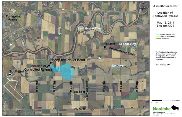 Satellite view of Hoop and Holler Bend region of Assiniboine River
showing area of breach with indication of controoled flooding.
Image courtesy of the Province of Manitoba 15 May 2011: The "controlled breach" is now expected to affect 180 sq. km instead of the 225 originally predicted. The province requested 100 more soldiers to help protect homes in the flood zone in addition to the 1500 soldiers already involved in the flood fight.
Manitoba Premier Greg Selinger expects the flood to cost around $200 million.
16 May 2011: As of Monday morning, the water was dispersing slowly across fields and then filling behind roads as planned. It had begun flowing into the Elm River channel that eventually flows into the La Salle River. Officials expected the Assiniboine to crest in Brandon today.
3 June 2011 The situation along the Red River and its tributaries remained critical into June and became worse in western reaches of the Red River Valley and heavy rains since mid-May caused extensive flooding along the Souris River in the latter days of the month. The Souris River, which originates in Saskatchewan, loops southward into North Dakota, and then flows back into Manitoba where it feeds into the Assiniboine River.
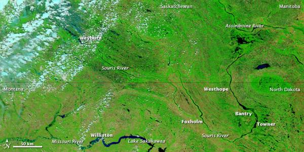 Flooding along the Souris River can be seen in this satellite image taken on 18 June 2011.
Image Courtesy NASA Earth ObservatoryAn example of the well-above normal rains can be seen in the Estevan, Saskatchewan weather data. By June 21, Estevan had recorded 324 mm (12.8 in) of rain since 1May , the wettest May-June period on record. As a benchmark, the Estevan's average annual rainfall is 333 mm (13.1 in).
17-22 June 2011 Weyburn, Saskatchewan and ninteen other Saskatchewan communities declared a state of emergency on 17-18 June as flood waters threatened or inundated many communities. The following week, the waters had reached Minot, North Dakota forcing the ordered evacuation of 12,000 residents. On the 22rd, the river overtopped the levees in Minot and was also threatening nearby Burlington, North Dakota, which led to evacuations in that community.
23-26 June 2011 The following morning, the Souris River at Minot had reached almost 2 metres (over 6 ft) above normal, and was closing in on the record high river levels set in 1881. By Sunday, 26 June, the river surged up 1.5m (5 ft) and its level established a new record of 1.561.72 ft above sea level. The old mark was 1558.0 ft. The river crested that day and water levels are ebbing in Minot. However, the flooding waters continue to rise downstream. A new record river level was also set at Sawyer ND on 24 June.
The flooding in the Red River Valley will continue through the summer as the floodwaters from the Souris flow into the Assiniboine and then the Red River in Manitoba.
Mississippi River Valley Flooding
In the Mississippi River Valley, flooding is forecast to begin or continue along the upper regions of the Mississippi and at the confluence with the Ohio River at Cairo, Illinois starting around 17 April. An April blizzard dumped heavy snow across the northern reaches of the valley, and heavy rains fell along the Ohio Valley during mid-April.
30 March 2011: Runoff from the Minnesota and St. Croix rivers caused rising waters downstream along the Mississippi River in the Upper Midwest. The Mississippi River at St. Paul was at major flood stage this week as a surge of water that flooded the Minnesota River to the west flowed into the river.
As a precaution, more than 300 volunteers began filling about 18,000 sandbags the past Sunday, March 28, in the Quad Cities area of Iowa and Illinois.
19 April 2011: Waters continue to rise along the Mississippi River. Homes and businesses along the river from near Dubuque, Iowa, to the Quad Cities are stacking sandbags. Many nearby roadways have been closed due to high water including the Savanna-Sabula bridge, an important thoroughfare that connects northern Illinois with central Iowa. Here are some flooding forecasts for cities along the Mississippi River, including stages as of Tuesday morning (19 April):
- Dubuque, Iowa: River stage as of Tuesday morning is 22.6 feet, 5.6 feet above flood stage. The river is forecast to crest at 23 feet tonight.
- Rock Island, Ill. (Quad Cities): River stage as of Tuesday morning is 19.2 feet, 4.2 feet above flood stage. The river is forecast to crest at 20.7 feet on Friday morning.
- Quincy, Ill.: River stage as of Tuesday morning is 18.1 feet, 1.1 feet above flood stage. The river is forecast to rise to 21.9 feet on Saturday.
- New Madrid, Mo.: River stage as of Tuesday morning is 33.9 feet, just below flood stage. The river is forecast to rise to 36 feet by Friday.
25 April 2011: Rainfall of biblical proportions has fallen across the Ohio River Valley so far this month. Louisville, Kentucky rreceived 10.42 inches (265 mm) of rain through April 25, more than triple the normal rainfall for this point in April. Cincinnati, Ohio accumulated 11.85 inches (301 mm) of rainfall, also triple their normal. Forecasters predict water levels 18 ft (5.5m) above flood stage on the Ohio River and its tributaries in Ohio, Indiana, Kentucky and Illinois
The Lower Mississippi River Flood Center predicted that the Mississippi River will rise above flood stage by the second week in May in Louisiana. Major flooding will occur as far south as Baton Rouge, Louisiana, where the river is forecast to be more than 6 feet (1.8 m) above flood stage by May 16. While the river is forecast to exceed flood stage near New Orleans, levees will protect the city until the river exceeds 20 feet (6.1 m). The current river forecast expects the crest at 17.5 feet (5.3m).
29 April 2011: A week of extreme rain along the Ohio and Mississippi River Valleys has greatly increased the flood risks along the Ohio River and Mississippi River south of Cairo, Illinois. Generally 6 to 12 inches 150-300 mm) of rain has fallen on portions of southeastern Missouri, southern Illinois, western Kentucky, Arkansas, Indiana, Ohio and western Tennessee this month. Cape Girardeau, Missour has recorded over 19 inches (483 mm) of rain this month, over five times the April normal. Rainfall up the Ohio River can be sensed by the accumulation at Cincinnati, Ohio, which has received over a foot of rain (300 mm), about four times its normal April rainfall.
Therefore, National Weather Service hydrologists forecast river levels along the Mississippi and Ohio rivers in southern Illinois, southeastern Missouri, western Kentucky and northwestern Tennessee to setnew record highs this weekend. As of 29 April, the water level at Cairo, an historic town of 2,800 people, was within 0.5 of a foot (15 cm) of tying the record mark of 59.5 feet (18.15 m).
30 April 2011: After getting the go ahead from Federal district court judge Stephen Limbaugh Jr, the Army Corps of Engineers are prepared to breach the levee at Birds Point, Missouri in order to prevent a levee breach at Cairo. (The levee breach would flood 130,000 acres of Missouri farmland, which contains about 90 homes.
1 May 2011: The State of Missouri had sought an injuction against the action which would flood Missouri farmland if it was deemed necessary to spare the flood-threatened Illinois town.) The Corps will detonate explosives in the levee if the Cairo river level reaches 61 ft (18.6 m). If the level is not breached, water in the streets of Cairo could reach up to 20 ft (6.1 m), topping a two-story house according to Corps estimates.
Army Corps of Engineers officials were monitoring water levels in order to decide whether to go through with the blast to blunt the rise of the Ohio River, which that afternoon had risen to 59.93 feet (18.28m) at Cairo — eclipsing the 1937 record there of 59.5 feet (18.14m). The river was expected to crest Tuesday at 61.5 feet (18.8 m) and stay there for days, thus raising the concerns about the strain on local levees. Cairo's flood wall can handle waters to 64 feet (19.5m).
The high water and saturated ground will delay the planting of crops in this area. The high waters will continue to move downstream in the weeks ahead, bringing threats of flooding to areas from Memphis to New Orleans.
2 May 2011: The Ohio River level at Cairo river reached 61.25 ft (18.68 m) this afternoon and peaked at 61.72 ft (62.02m) that afternoon, seven hours after the Corps blasted a breach in the levee at the Missouri community of Birds Point. The blast caused waters from the swollen Mississippi River to flood 130,000 acres of prime agricultural lands in southeastern Missouri.
The bad news is that flooding along the lower Mississippi River will worsen and surpass earlier estimates as the runoff from nearly two feet (0.6m) of rain that fell on parts of the mid-Mississippi and Ohio valleys works its way downstream.
4 May 2011: Major flooding along the Ohio River extends from Shawneetown, Illinois to Cairo. The Wabash River at Mt Carmel, Illinois reached a new record peak of 33.96 ft (10.36m).
The flooding on the Mississippi River from Rock Island, Illinois to Burlington, Iowa has crested. The river crest continued downstream and was located at Chester, Illinois. Major flooding is anticipated from Chester to Osceola, Arkansas in the next days. Caruthersville, Missouri became the most recent location along the Mississippi River to set a new record stage when the river exceeded the old record level of 46.0 feet (14 m) set in 1937 and was still rising.
The National Weather Service's River Forecast Center now expects the lower Mississippi River to approach or surpass river levels not seen since 1937, and in some cases 1927. IThey foresee the river significantly overflowing its banks in eastern Arkansas, western Mississippi and Louisiana as flood waters farther upstream drain southward to the Gulf of Mexico.
Record flooding was forecast at New Madrid, Missouri where at 50 ft (15.2m), the river would exceed the record stage of 48 ft (14.64m) set in 1937. Major flooding will move along the lower Mississippi River from Tiptonville, Tennessee to Donaldsville, Louisiana through the early part of June. This included the cities of Memphis, Tennessee, Natchez, Mississippi and Baton Rouge, Louisiana where record or near-record water levels will occur..
5 May 2011: Major flooding caused Kentucky officials to close 250 roads in 50 counties. Rising waters along the White River, which flows into the Big Muddy, has closed sections fo Interstate 40 in Arkansas. In Louisiana the National Guard used sandbags to fortify levees in the northeast region of the state. A major disruption of river traffic began when the US Coast Guard closed a 5 mile (8 km) section of the river near Caruthersville, Missouri.
6 May 2011: The Mississippi River at Tiptonville, Tennessee crested at a record 48.4 feet (14.76m) at 12 am on Friday.
7 May 2011: The Mississippi River at Caruthersville, Missouri, crested at 47.6 feet (14.51 m) on Saturday, a record.
9 May 2011: Army Corps of Engineers spokesman Bob Anderson said in Vicksburg, Mississippi that flooding along the Mississippi and its tributaries could rival the deadly 1927 flood in the region. The flood crest is forecast to move slowly downstream towards New Orleans during the next 3 weeks through Tennessee, Mississippi and Louisiana.
To relieve pressure caused by the surging river, the Bonnet Carre Spillway near New Orleans was opened.
National Weather Service hydrologists predict that even with the opening of the spillway, which directs water into Lake Pontchartrain, the Mississippi River icould crest within 0.5 ft (15 cm) of the top of the New Orleans levees that protect the Big Easy from the Mississippi River.
In the next few days, officials will decide for the first time since 1973whether to open the Morganza Spillway which directs water into the Atchafalaya River near Baton Rouge, Louisiana. The opening would direct flood waters into prime agricultural areas and part of Lafourche and much of Terrebonne parishes as well as Pointe Coupee, St. Landry, St. Martin, Iberia, Iberville and St. Mary parishes.
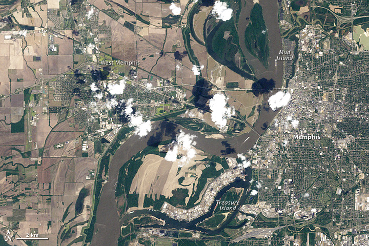
10 May 2011: The Mississippi River flood crest reached Memphis, Tennessee, where it was within a foot of the record flood stage. The crest then proceeded downstream through the Lower Mississippi Basin towards New Orleans, Louisiana, during the next two weeks, with major to record flooding expected along the way.The river level at Memphis crested at 47.87 feet (14.59 meters). It was the highest water level for Memphis since 1937, when the river reached 48.7 feet (14.8 meters).
The satellite images from the Thematic Mapper on NASA'sLandsat 5 below shows flooding on the Mississippi on 10 May 2011 compared with the same location in April of 2010.
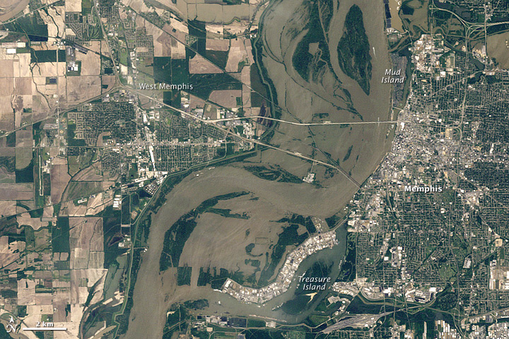 |
Flooding in Memphis, Tennessee, 10 May 2011
Thematic Mapper on Landsat 5, Courtesy NASA |
 |
Flooding in Memphis, Tennessee, 21 April 2010
Thematic Mapper on Landsat 5, Courtesy NASA |
13 May 2011: The Mississippi River flood crest is forecast to continue to move slowly downstream towards New Orleans during the next 2 weeks. The Mississippi River at Vicksburg, Mississippi is forecast to crest on May 19 at 57.5 feet (17.5m). Over 600 have been evacuated in Vicksburg. About 3 million acres of farmland are flooded in four states. In Louisiana, twenty-six parishes in the state have declared states of emergency ahead of the surging waters.
Chris Bonura, a spokesman for the Port of New Orleans, said the Coast Guard plans to close a 190-mile stretch of river from Baton Rouge to the Gulf of Mexico when the water reaches the 18-foot level at a gauge in Carrollton. The action would cause the mouth of the Mississippi to become crowded with ships, though some might be diverted to other ports. In addition, barges headed south from the nation's heartland to the Port of South Louisiana at Reserve, upriver from New Orleans, would be unable to reach grain elevators. As a consequence, ships that carry US corn, soybeans and other crops out of the country would be unable to move.
14 May 2011: Corps engineers ordered the Morganza spillway opened in south-central Louisiana to alleviate pressure from the dangerously swollen Mississippi River on levees in the large population centers of Baton Rouge and New Orleans. The hope is that by diverting some of the waters, New Orleans will avoid another catastrophic floodng as happend with Hurricane Katrina. According to Army Corps estimates, the diverted floodwaters are expected to flood a swath 20 miles (32 km) wide and 150 miles (240 km) long, and up to 25 feet (7.6m) deep along southern Louisiana's Cajun country. The area is home to about 25,000 people, and 11,000 buildings and homes are in the path of the floods.
The hope is that by diverting some of the waters, New Orleans will avoid another catastrophic floodng as happend with Hurricane Katrina. If the spillway was not opened, flood waters were predicted to peak at the Carrollton Gage at 19.5 ft (5.95m), just shy of the city's floodwall top which stands at 20 ft (6.1m).
15 May 2011: As of Sunday (May 15), according to a spokesman for the US Army Corps of Engineers, 2.1 million acres of land were underwater in central Mississippi.
17 May 2011:The Mississippi flood crested near the Arkansas City, AR area with preliminary peak crest around 53.1 feet (16.2 m). The Mississippi River at Natchez approached 62 feet (18.9m) in the morning, 14 feet (4.27 m) above flood stage and almost 4 feet (1.22m) higher than the all-time crest recorded in 1937. Forecasts suggest the river hat Natchez could remain at this level for at least another week.
The Corps of Engineers reports 11 of 125 gates had been opened at the Morganza Spillway and 330 of the 350 gates on the Bonnet Carre’ spillway.
The Coast Guard had closed a15-mile (25 km) stretch of the Mississippi River near Natchez, MS to river traffic. However, it later reopened the stretch to single vessel traffic moving at a slow speed. This allows important barge traffic to bring corn, grain and soybeans to the Louisiana ports. Officials had feared that full interruption of this flow of barges would cost the US economy hundreds of millions of dollars daily.
In Manitoba on the Red River, provincial officials said the cost of this year's flooding could exceed that of the "Flood of the Century" in 1997, which rang in at around $500 million (Canadian). They pegged flooding on the Assiniboine River at the once in three hundred years return period.
20 May 2011:The Mississippi crested at 57.1 feet (17.4m) in Vicksburg MS and was expected to hold there until at least Saturday morning (May 21).
Four barges broke loose in Baton Rouge LA and sank causing a five-mile eight-km) section of the river to be closed,
21 May 2011:With water levels on the Assiniboine River in Manitoba receding, officials ordered the breach in the dyke at Hoop and Holler Bend to be repaired. The release of flood waters through the intentional breach flooded 3.4 million square kilometres, an area smaller than initially expected.
23 May 2011:The Army Corps of Engineers reported that the opening of two spillways on the Mississippi River have done their job and as a result, the river level at New Orleans LA is holding at 17 ft (5,18m), 3 ft (0.91m) below the tops of floodwalls. However, the opening of the spillways has unundated 1.3 million acres of farmland and communities in Cajun County of southern Louisiana.
27 May 2011:Along the lower Mississippi River, the river has crested from Tiptonville, MO to New Orleans LA. At Memphis TN, the river will likely drop below flood stage in the next 24-36 hours. Recent rainfalls will send a second crest down the river from Tiptonville; however, it will be significantly lower than the initial flood crests. The river from Memphis to New Orleans is forecast to remain above flood stage until mid- to late June.
The U.S. Army Corps of Engineers has started closing gates on the Morganza Spillway, only 14 of the 125 gates were still open as of Wednesday (26 May) evening.
3 June 2011 Though it may take months before the flood waters on the Mississippi River recede to more normal levels, the brunt of the flooding for the Spring of 2011 is over here. Thousands of acres of crops, catfish farms and timber remain still flooded, mostly along tributaries that backed up due to the high waters in the Mississippi River. Hundreds of families are still displaced from theirflooded homes, and many have lost their homes to the flood waters.
Significant River Flood Outlook Maps for 2011
The maps below shows the Significant River Flood Outlook as reported by the US National Weather Service.
|
Issued 3 April 2011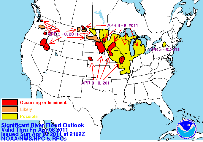 |
Issued 17 April 2011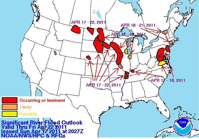 |
Issued 25 April 2011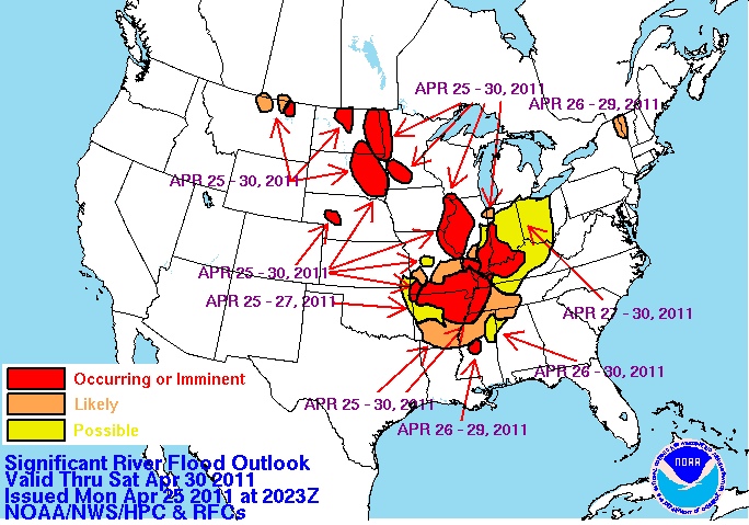 |
Issued 28 April 2011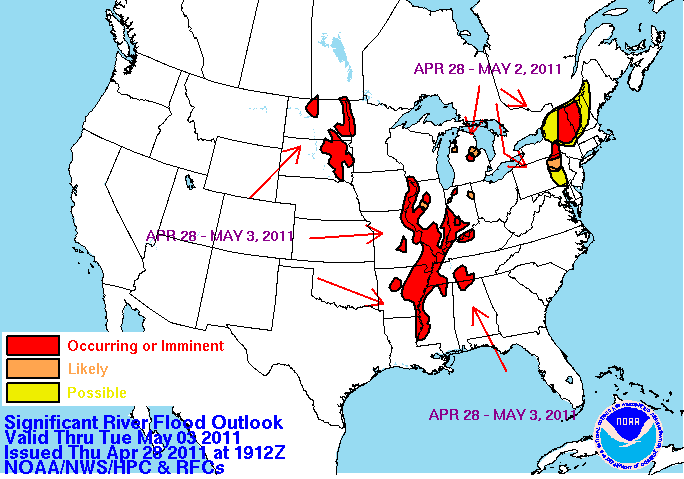 |
Issued 9 May 2011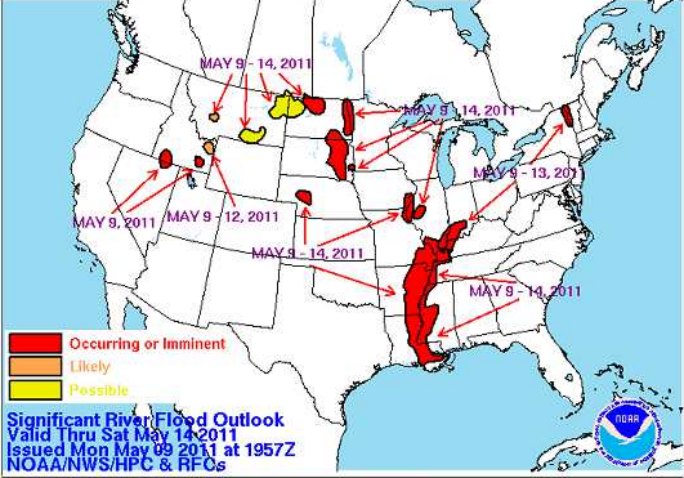 |
Issued 12 May 2011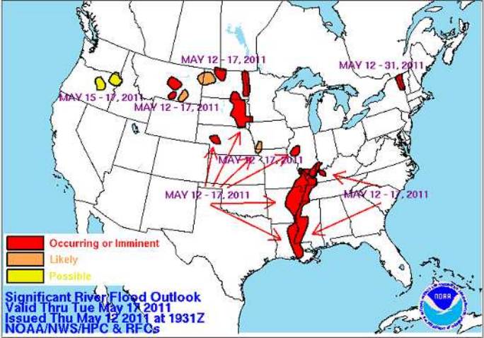 |
Issued 15 May 2011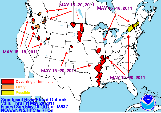 |
Issued 20 May 2011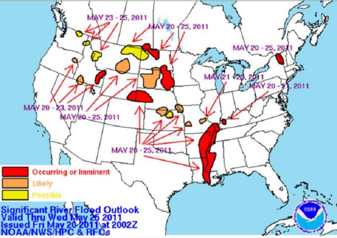 |
Issued 26 May 2011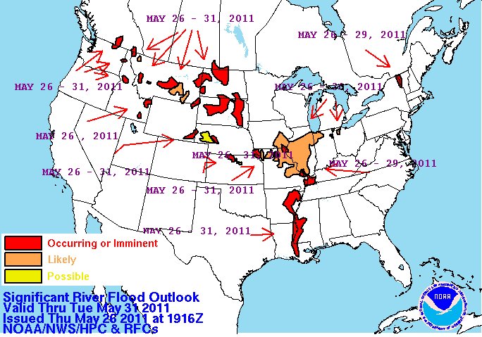 |
Issued 8 June 2011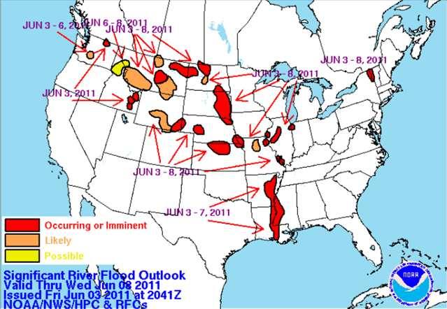 |
Issued 29 June 2011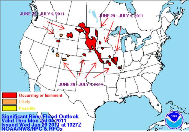 |
Legend description:
Occurring or Imminent - Significant flooding is already occurring or is forecast to occur during the outlook period.
Likely - Hydrometeorological conditions indicate that significant flooding can be expected during the outlook period.
Possible - Hydrometeorological conditions indicate that significant flooding could occur. Such flooding is neither certain nor imminent.
Images courtesy of US National Weather Service, NOAA.
|
Learn More From These Relevant Books
Chosen by The Weather Doctor
- Barry, John M.: Rising Tide, 1998, Touchstone Books, Simon and Schuster, New York, ISBN 0684840022.
- Burt, Christopher C.: Extreme Weather: A Guide and Record Book, 2007, W. W. Norton & Company, ISBN 039333015X, paperback.
- Williams, Jack: The AMS Weather Book: The Ultimate Guide to America's Weather , 2009, University Of Chicago Press, ISBN: 0226898989.
Written by
Keith C. Heidorn, PhD, THE WEATHER DOCTOR,
May 16, 2011, revised May 27, 2011.
The Weather Doctor's Weather Almanac: 2011 Spring Flooding in the Mississippi and Red River (North) Valleys
©2011, Keith C. Heidorn, PhD. All Rights Reserved.
Correspondence may be sent via email to: see@islandnet.com.
For More Weather Doctor articles, go to our Site Map.
 |
Now Available The Field Guide to Natural Phenomena:
The Secret World of Optical, Atmospheric and Celestial Wonders
by Keith C Heidorn, PhD and Ian Whitelaw |
Now Available! Order Today! |
 |
 |
|
|
Home |
Welcome |
What's New |
Site Map |
Glossary |
Weather Doctor Amazon Store |
Book Store |
Accolades |
Email Us
|


