| Home | Welcome | What's New | Site Map | Glossary | Weather Doctor Amazon Store | Book Store | Accolades | Email Us |
 | |||||||||||||
Weather Almanac for April 2011Spring FloodingAs the melting of winter’s snowpack and the onset of spring rains spread across the watersheds of the great rivers that drain much of the Plains States and Prairie Provinces of North America, the fear of extensive spring flooding arises. While such worries arise each year, hydrologists on both sides of the Canada/US border are very concerned about the prospects for widespread flooding in 2011.
In particular, I consider flooding in the Mississippi River, Missouri River and Red River of the North floodplains. The former two drain the northern American Plains heading for the Gulf of Mexico; the latter also begins in the American Northern Plains states but instead moves northward into the Canadian Province of Manitoba to Lake Winnipeg, the world’s eleventh largest freshwater lake. Lake Winnipeg, which also receives waters from across the Canadian Prairies, ultimately drains northward to Hudson Bay and the Arctic Ocean. 2011 Flooding FearsAs of late March 2011, flood forecasters with the US National Weather Service (NWS) were warning of “potentially catastrophic flooding” (95% chance) beginning in April over nearly half the United States, and particularly down the Mississippi Valley from its headwaters to New Orleans. Several major metropolitan areas sit in the upper Mississippi basin from Minneapolis/St Paul, Minnesota to St Louis, Missouri. In addition, cities where flooding is feared along the Red River include Grand Forks, Fargo and Sioux Falls in North Dakota, and Winnipeg in Manitoba. 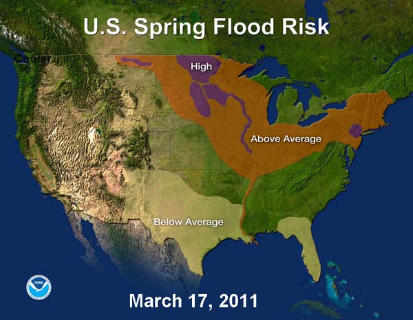 Courtesy US National Weather Service (NWS)In Manitoba, the Manitoba Water Stewardship also anticipates severe flooding this spring along the Red, Souris, Pembina, Assiniboine, Winnipeg, Saskatchewan and Fisher Rivers that could reach record water levels. At the time of this writing, the flooding was expected to be of similar size to that in 2009 but could reach the levels of 1997, particularly if late Spring precipitation is heavy. Current Environment Canada long-range forecasts called for a wetter than normal April-May-June for Central Manitoba. The US Climate Prediction Center for the same period also foresaw above normal precipitation for North Dakota and northwestern Minnesota. The reason for the concern began with heavy late summer and autumn precipitation in 2010 where twice the normal amount fell in parts of North Dakota and Minnesota. That left soils saturated and streams running high before the winter freeze-up. The winter snowfall was also heavier than normal, and temperatures continued below freezing over most of the winter, which allowed the snowpack to remain deep in many areas of North Dakota, northern Minnesota and northern Wisconsin. In places, the depth of waterlogged snow on the ground in mid-March measured 1 to 3 feet (30-90 cm). Typically, snowfalls in this area are dry and powdery and have a low water content. But the 2010-11 season’s snowpack held a water equivalent of 1 to 6 inches (2.5-15 cm), which ranked among the highest moisture contents of the last 60 years for the region. At Fargo, North Dakota, however, the water content was nearly twice that normally expected at this time of the year.
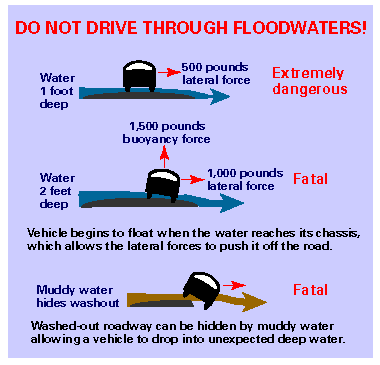
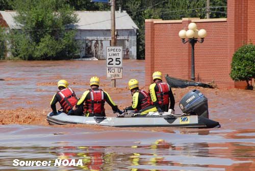
The National Hydrologic Assessment, a report issued each spring by the NWS, provides an outlook on US Spring flood potential. Its assessment for the Lower Mississippi River in Spring 2011 warns: “This spring, as flood waters drain from the Upper and Middle Mississippi and Ohio Rivers, the flood threat downstream to the Gulf of Mexico will increase. Despite dry conditions through much of the Gulf Coast over the winter, the Lower Mississippi River now has an above average risk of flooding. Recent snowmelt and rains across the Ohio, Cumberland and Tennessee Rivers are currently producing moderate to major flooding on the Lower Ohio River and Mississippi River above Memphis, TN.” And the unprecedented snowpack continued to accumulate in the upper drainage basins of these rivers as heavy snows fell in the last ten days of March, particularly across the Dakotas and Minnesota to Wisconsin. In Minnesota, hydrologists expect the Mississippi River to hit record levels. Near St. Paul, the river was expected to crest before the month’s end. Flood ImpactsThree quarters of all US presidential disaster declarations arise from flooding events. We know that river basin flooding causes extensive property and infrastructure damage, but flooding can have extreme negative impacts on agriculture in the flood zone. Millions of acres of cropland risk being flooded across this Breadbasket on North America. Waterlogged or covered soils can prevent or delay planting of crops, and may destroy newly planted crops. Loss of crops can be particularly critical this year (2011) as weather takes its toll on agricultural production across the world, resulting in high prices as shortages of certain commodities. And while the impacts on property and industry can rise into the billions of dollars (averaging $5.2 billion annually), there is a human toll as well. In the USA, nearly 100 people are killed annually by floods, and more than half that number result from flood-related traffic accidents, particularly when drivers venture down flooded roadways and are swept into deeper waters. It takes as little as 6 inches (15 cm) of standing water for a driver to lose control of their vehicle, even less if speed is involved. Around 2 feet (60 cm) of water can float an automobile.
As a result, the US NWS Awareness campaign is pushing for heightened awareness on the roads during flood emergencies. Their catchphrase for this campaign is:”Turn Around, Don’t Drown.” Flooding EventsMany significant floods have occurred along the Mississippi, Missouri and Red River floodplains during recorded history. Two of the most recent of major significance were the Mississippi/Missouri Valley flood of 1993 and the Red River flood of 1997. Summaries of these events can be found in these two pieces: The 1993 Mississippi/Missouri Valley FloodThe 1997 Red River FloodThe 2011 FloodingAs the flood story unfolds, now passing mid-May, I have moved my summary of the events to a second page: 2011 Spring Flooding in the Mississippi and Red River (North) Valleys. Please click on the title to continue reading. Learn More From These Relevant Books
|
|||||||||||||
 |
Now AvailableThe Field Guide to Natural Phenomena: |
Now Available! Order Today! | |
 |
 |
Now |
The BC Weather Book: |


 The problem is not unique to this great watershed. Indeed, this year flood forecasters in the US are also concerned about flooding on the Ohio River, which feeds into the Mississippi River drainage system at Cairo, Illinois, and in areas of southern New York State, New Jersey and Pennsylvania. Concerns always increase for flash flooding in the Spring, of course, particularly when heavy rains hit an area where soils are already saturated from previous rainfalls and melting snowpacks. Herein, however, I will focus on flooding that results from the melting of snowpacks augmented by spring rains that overwhelm a major river’s capacity to move that water toward the sea. (For more on flash floods, see my article
 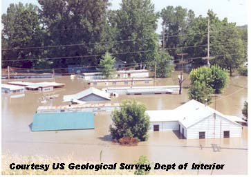 The NOAA forecasters consider the flood threat immanent, along the Red River, which forms the state line between eastern North Dakota and northwest Minnesota; the Milk River in eastern Montana; the James and Big Sioux Rivers in South Dakota; and the Minnesota River. Excluding the Red River, all these drain rivers into the upper Mississippi River basin. The danger will increase if any large spring storms bring heavy rains or more snow to the area. The long-range weather forecasts issued by the US Climate Prediction Center predicts above normal precipitation for the Dakotas during April/May/June. If this forecast is manifest, flooding will be more severe and prolonged.