In 1958, a young singer Richie Valens recorded a song entitled Donna and it became a rock and roll hit through 1959. Tragically, Valens died early that year in the infamous airplane crash that also took the lives of Buddy Holly and The Big Bopper. In that song, written about his real-life sweetheart, Valens sings “Since she left me, I’ve never been the same.” A year later, a hurricane named Donna struck the Leeward Islands, Puerto Rico, Cuba, The Bahamas and the US Atlantic Coast in September of 1960. The hurricane left many communities echoing Valens’ words as damage estimates came to about $387 million in 1960 US dollars (equivalent to $2.8 billion today). The fatalities attributed to Donna numbered at least 364 with 50 of those in the United States.
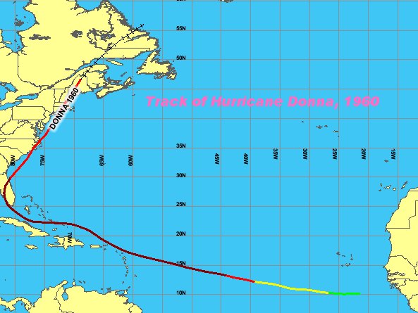
During its lifetime, which ran from 28 August when it was first detected as a tropical wave to its final tropical breath on 14 September, Donna would become one of the most destructive Atlantic tropical storms of all time. It produced hurricane-force winds all along the US coast from Florida through the Carolinas to New England. This hurricane also raged the longest at major hurricane status (Saffir-Simpson hurricane scale rating of 3 or higher) of any Atlantic storm, sustaining winds in excess of 115 mph for nine days (2-11 September). Donna, the only major hurricane of the 1960 season, is classified as a Cape Verde storms and was the first so-classified on record to hit the US mainland. Four other Cape Verde hurricanes have hit the US mainland since then: Hurricane Hugo (1989), Hurricane Georges (1998), Hurricane Isabel (2003) and Hurricane Ivan (2004).
(Cape Verde hurricanes are those Atlantic hurricanes that develop into tropical storms fairly close (<1000 km (600 mi) or so) to the Cape Verde Islands and subsequently become hurricanes before reaching the Caribbean.)
Formation and Early Days
Hurricane Donna began as a tropical wave off the African continent on 28 August and quickly asserted its deadly nature. An airliner crashed at Dakar, Senegal on the 29th, which was attributed to the weather disturbance. Late on the 29th, the system had organized into a tropical depression and became Tropical Storm Donna the next day. This Cape Verde-type tropical storm moved westward and continued to intensify. Hurricane status was reached on 1 September when the storm was located near 14 deg North, 49 deg West heading on a west-northwestward track.
Three days later, Hurricane Donna, now a Category 4 hurricane which briefly reaching Category 5 status, struck the northern Leeward Islands, its eye passing over Barbuda, St. Batthelmy, St. Maarten, Anguila, and passing about 16 kilometres (10 miles) south of Anegada. St. Maarten Airport reported a sustained wind of 120 mph (195 km/h) and pressure of 952 mb (28.11 in Hg). There, the hurricane caused extensive damage, killing seven and leaving at least a quarter of the island’s population homeless. Similar conditions were reported in Anguilla with one fatality.
Next in line were the Virgin Islands and Puerto Rico. Moving north Donna whose eye passed 56km (35 miles) offshore of St Thomas, which observed a 41 mph (66 km/h) wind gust. Though Donna caused minimal damage across the Virgin Islands, seven people died. The hurricane’s eye passed north of Puerto Rico on the 5th sparing it the strongest winds. However, intense rain in eastern Puerto Rico — over 10 inches (250 mm) — caused flash flooding that killed 107 people (85 of them in Humacao).
Donna then turned westward, slowly skirting the Turks and Caicos Island, bringing 50 to 60 mph (80 to 97 km/h) winds and dumping 12 inches (305 mm) of rain during the half-day passage. On the 7th, it headed across the southeastern Bahamas, blowing away the anemometer at Ragged Island with a 150 mph (240 km/h) gust. At Mayaguana, hurricane force winds raged for 13 hours and several communities on the smaller islands sustained severe damage. Many residents sought shelter in the missile-tracking base located on the island. North Caicos Island was deluged by 20 inches (510 mm) of rainfall in 24 hours, but despite the severity of the tempest, no deaths were reported.
As Donna headed toward the Florida Keys, it skirted the Cuban coast on the 9th, bringing gales, high surf and heavy rains to Cuba. The storm’s central pressure falling from 948 mb (27.99 in Hg) on the morning of the 9th to 932 mb (27.52 in Hg) late the following day, its lowest pressure during its lifetime. Peak winds were estimated to be blowing at 130 mph (208 km/h).
Making Landfall in Florida
South Florida and the Keys were next to suffer Donna’s onslaught as the storm track aimed for the Gulf of Mexico. The Keys were ready for the storm this time, mindful of the deadly Labor Day storm in 1935. About half of the residents from Marathon to Tavernier chose not to chance staying and fled the approaching hurricane. A hurricane watch was issued for the Keys and the south Florida coast just after the noon hour on 7 September and hurricane-warning flags were flying less than 24 hours later. Bulletins issued by the US Weather Bureau put the hurricane’s energy in frightening perspective:
“The energy released by a hurricane of Hurricane Donna’s size is the same as a hydrogen bomb exploding every eight minutes.” (Warning issued by the National Weather Bureau, September 1960.)
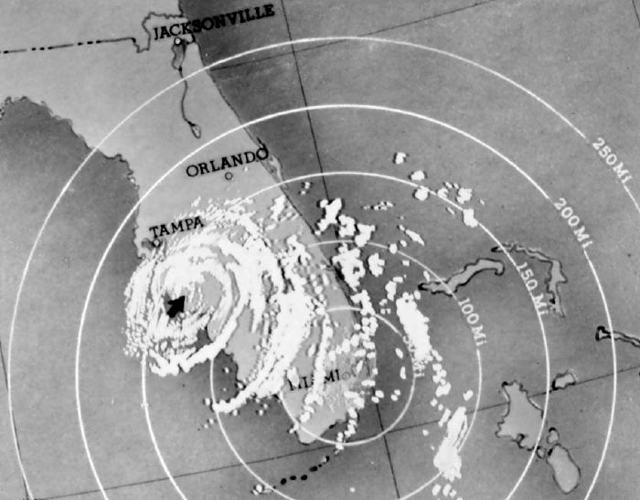
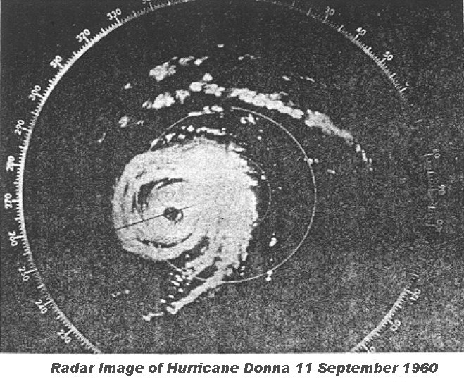
In Miami, the city prepared for its first hurricane in a decade, but Donna’s eye passed 96 km (60 miles) west of the city on the 9th. Maximum winds reported in Broward County hit 80 mph (128 km/h) winds and caused minor damage: a few trees and signs knocked down. Rainfall was intense, however, falling at the rate of 25 mm (one inch) per hour. A radar image of Donna at its closest position to Miami shows an eye about 33 km (21 miles) in diameter and a wall cloud band 27-32 km (17-20 miles) wide.
Photo of radar image of Hurricane Donna on 10 September 1960 at 6:00 PM EST over Florida. The eye is indicated by an arrow. Source: National Oceanic and Atmospheric Administration, (Washington , DC: U. S. Department of Commerce, 1960)
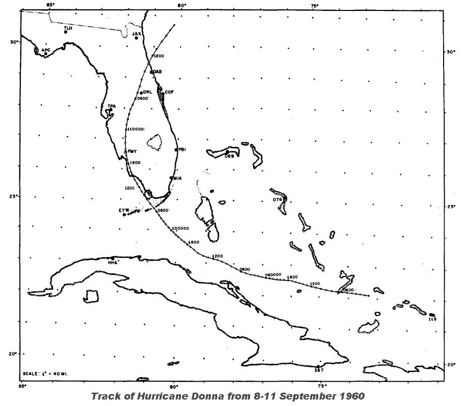
Winds reached gale-force across the Florida Keys on the early evening of 9 September and increased until the early morning hours of the 10th. Hurricane Donna made its first landfall in Florida at Marathon, on Key Vaca in the middle Keys. It hit Marathon with a storm surge of 2.4-2.9 m (8-9.5 ft) and Matecumbe Key with a 2.7-4.1 m (9-13.5 feet) surge. At Tavernier, the sea level reportedly reached within 46 cm (18 inches) of the high water mark established in the devastating Labor Day storm of 1935. The surge was generally 2.4-3.7 m (8-12 ft) along a line from 64 km (40 miles) northeast of the track to 32 km (20 miles) to the southwest. Officially, 307 mm (12.1 inches) of rain fell on Marathon.
At the time of landfall, Donna was a Category 4 hurricane with estimated maximum sustained winds of 140 mph (230 km/h) and gusts of up to 180 mph (290 km/h) and minimum central pressure of 930 mbar (27.46 in Hg). That pressure reading, at the time was the fifth lowest central pressure for any hurricane while hitting the United States. The storm’s 21-mile (34 km) wide eye swept over the middle Keys between 2 and 3 AM on 10 September just to the northeast of Marathon. At Key West, on the outer edges of the storm, the maximum winds would be reported blowing at 65 miles per hour (105 km/h).
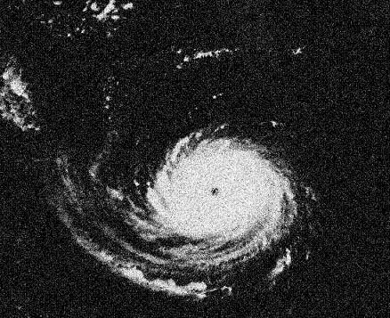
Hurricane Donna lies off southwest Florida Coast.
Keys residents, for 64 km (40 miles) either side of the storm track experienced the worst tropical storm to strike the region since 1935. According to the US Weather Bureau storm summary, “Destruction from the combination of wind and water in this area ranged from major to almost complete.” Damage at the point of first landfall was most severe, described by one witness as “appalling” and storm surge demolished many buildings and vessels into matchsticks. Utility poles snapped in two. Fortunately, the fatality toll was only four compared to the 400 dead counted in 1935.
Bridges linking the Keys were washed away including a 305 m (1000 ft) concrete span of the Tea Table Bridge between Upper and Lower Matecumbe. At Islamorada, nearly every home, business and resort along the shoreline was either gutted or destroyed, many floating two or threes blocks away. Coral reefs in the Key Largo National Marine Sanctuary were severely damaged by the hurricane surge and surf. When residents returned to see what remained, they encountered piles of debris and many were in shock — what physicians in Miami would later term “hurricanitis.”
The hurricane’s forward motion slowed as it crossed the Keys and moved toward the mainland of southwest Florida. At the Everglades National Park, officials measured a pressure of 944 mb (27.9 inches Hg) and winds estimated at around 150 mph (240 km/h): all wind instruments had been blown away during the tempest. Donna destroyed nearly half of “the largest stand of big mangrove trees in the world,” many of which had survived the 1935 hurricane. The storm also killed 35-40 percent of the endangered great white herons living in the park and destroyed nearly all of the bald eagles’ nests, the nation’s largest concentration of nesting (and then endangered) bald eagles. The storm’s eye passed over Everglades City around 9:30 AM on 10 September, bringing a damaging storm surge of over 3.05m (10 ft) in its wake. Half of the town buildings were destroyed. The impact of Hurricane Donna nearly killed the town.
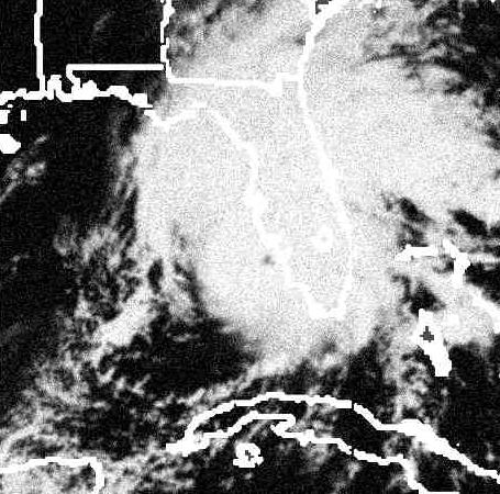
At this point, Donna had briefly moved over the waters of the Gulf of Mexico before turning northward toward Naples and Fort Myers making landfall there as a Category 4 hurricane. Pummeling Florida’s southwest coast, Donna demolished the famous Naples Fishing Pier that had withstood many hurricanes since its construction in 1888. The central pressure recorded as the eye passed over the Naples weather station stood at 947 mb (27.97 inches) on 10 September.
The eye passed over Fort Myers at around 2:30 PM with a pressure of 951 mb (28.08 inches) a record low pressure for the city, with winds preceding it gusting to 120 mph (193 km/h). At this point, Donna began to curve to the northeast across the Florida Peninsula. In Hardee County, wind gusts measured 140 mph (225 km/h) at Wauchula and 150 mph (240 km/h) at Fort Meade. The storm passed over Lake Apopka and Winter Haven and west of Orlando and Daytona Beach before crossing the Atlantic coastline south of Flagler Beach heading out to sea.
Composite radar image of Hurricane Donna when south of Tampa/St Petersburg. 10 Sept 1960, 6 AM National Weather Service (NWS) Collection
Hurricane Donna was widely regarded as the most destructive hurricane to date in Florida history. The state suffered significant losses from Donna with total damages pegged at $300 million ($2.2 billion in 2009 dollars), more than any other state. Agricultural losses were pegged at $50 million ($362 million in 2009 dollars). The US Department of Agriculture estimated that 25-35 percent of the grapefruit crop was destroyed along with 5-10 percent of the orange and tangerine crops. Avocado and truck crops also sustained heavy damage, the latter due to flooding from the hurricane rains falling on already saturated soil.
Thirteen people lost their lives due to Donna in Florida with 122 hospitalized due to injury. An estimated 1844 homes were lost during the storm, another 3253 suffered major damage, and 31,000 minor damage.
North to Carolina
By the afternoon of 10 September, Hurricane Donna again sat in the warm Atlantic waters moving northward along the Georgia and South Carolina coasts at a speed of 14 mph (22 km/h). The US Weather Bureau posted hurricane warnings at 11 AM on 11 September for the coastline from Savannah, Georgia to Myrtle Beach, South Carolina. At 5 PM, they extended hurricane warnings northward to include the entire North Carolina coast. Fueled by the warm Gulf Stream current, Donna regained the strength it lost while crossing the Florida Peninsula.
The SS Mae located in the Atlantic about 128 km (80 miles) southeast of Charleston, South Carolina reported winds of 120 mph (193 km/h)and 6-9 m (20-30 ft) seas. Winds along the Charleston area beachfront blew at up to 70 mph (112 km/h). Wind damage was widespread in coastal areas. For example, in Beaufort County, South Carolina, Donna downed power lines, uprooted trees, unroofed homes, destroyed piers and significantly damaged corn and soybean crops.
On the evening of 11 September, the hurricane made landfall near Topsail Island, North Carolina located northeast of Wilmington. Storm surges of 1.2-2.4 m (4-8 ft) were reported along portions of the North Carolina coast with winds in excess of 100 mph (160 km/h). The hurricane’s central pressure ranged from 958 to 967 mb (28.29-28.56 in Hg) during its passage across the Carolina coast. Wilmington reported a gust peaked at 97 mph (156 km/h), and higher speeds were observed along the Outer Banks to the north. Swansboro, Morehead City, Beaufort and Atlantic Beach sustained considerable damage to homes and other buildings, as did Carteret, Pamlico, Hyde and Tyrrell Counties. Donna’s storm surge cut through protective dune barriers, overwashing streets and flooding homes. The Dunes Club near Oceanna Pier was destroyed by surge and wave action that also washed out the roadway, stranding the Coast Guard station.
Damage to the Morehead City—Beaufort Causeway was even greater than that sustained during Hurricane Hazel in 1954. The waters cut the sand out from under the pavement as well as the rails of the Beaufort and Morehead Railroad, where a locomotive hung precariously. At the storm’s peak, an ambulance was swept off the causeway as it sped toward Morehead Hospital with a pregnant woman now in labor. Attendants and the woman gained shelter in a nearby house where they rode out the storm. (There was no birth that night, and the child was safely born two weeks later.)
The Outer Banks took the full brunt of Donna as they sat in the dangerous northeast quadrant of the storm where wind speeds are increased by the storm’s forward motion (in this case about 35 mph / 56 km/h). The winds at Manteo on Roanoke Island, for example, gusted to 120 mph (193 km/h). The winds ripped off roofs and downed miles of power and telephone lines. Donna demolished dozens of homes at Kitty Hawk and Nags Head sweeping three into Roanoke Sound. Heavy damage occurred in New Bern, Washington, Edentown, Swan Quarter and Elizabeth City to name just a few of the communities affected. Even inland cities such as Goldsboro and Greenville experienced damage. To add insult to injury, two tornadoes spun up by the hurricane struck, one in Bladen County, the other in Sampson County.
Before Donna moved back out to sea near Virginia Beach, Virginia at about 5 AM the next morning, eight people in North Carolina had died due to the storm and over a hundred sustained injuries. As Donna laid off the coast early on the 12th, the hurricane still maintained Category 3 strength.
To New England and Dissipation
At 9 PM on 11 September, hurricane warnings were extended northward to Portsmouth, New Hampshire, and gale warnings and a hurricane watch were issued northward to Eastport, Maine. In preparation, many ships docked in Newport, Rhode Island were towed out into the bay to ride out the impending storm.
As Donna sped northward at a forward speed of 35-40 mph (56-64 km/h) along the mid-Atlantic Coast, wind gusts of 105 miles per hour (169 km/h) were reported along the eastern shore of Chesapeake Bay. Hurricane force winds with gusts over 100 mph (160 km/h) raked the Maryland, Delaware and New Jersey coasts.
Shortly after noon of 12 September, Donna made landfall for the last time on the southern shore of Long Island, New York before crossing onto the New England coast. Its maximum sustained winds hit 105 miles per hour (169 km/h) with gusts of 115 miles per hour (185 km/h) at Montauk, Long Island and Block Island, Rhode Island. The pressure measured at Brookhaven, Long Island was 961 mb (28.38 in Hg), indicating that Donna had maintained intensity in its flight from North Carolina and its eye had widened to 80-160 km(50-100 miles) in diameter, an extreme size for a hurricane eye.
The attendant storm surge measured 3.4 m (11 feet) in New York Harbor, which wrecked many local piers, and 1.5 to 3 m (5-10 ft) surges were observed along portions of the New England coast. It was perhaps fortunate that the storm hit at normal low tide, thus minimizing the damage that may have been inflicted had it arrived at a higher tide time. Even so, there was considerable damage to properties along the coast from the Middle Atlantic to New England States.
When the storm passed over Blue Hill Observatory in Milton, Massachusetts gusts still blew over 145 miles per hour (233 km/h). At Chatham, Massachusetts, the strong southwest winds, in combination with very little rainfall preceding the hurricane, produced a significant deposit of salt spray, which whitewashed southwest-facing windows. Leaves on many trees and shrubs later turned brown due to salt accumulation.
By late that day, Donna still held hurricane strength as it spread damage into the New England states. Gradual weakening occurred as the storm continued racing rapidly northeastward through Maine. However, hurricane force winds still held, and thus Donna affected every state on the US Atlantic Coast. In fact, it is the only storm to bring hurricane-force winds to every location along the Atlantic Coast from Florida to Maine.
Crossing the border near Caribou, Maine, Donna moved into Canada on 13 September, and finally became extratropical over the New Brunswick/Eastern Quebec. The system continued northward into Labrador and finally dissipated as a weakening frontal disturbance over the North Atlantic.
One For The Books
In addition to its hurricane winds and high storm surge, Donna dumped heavy rains from Florida to Maine. From 254 mm (10 inches) to 305 mm (12 inches) of rain fell across the southern half of Florida, along with about 178 mm (7 inches) in the northern half. A swath of rain measuring 132 to 254 mm (5 to 10 inches) fell from North Carolina northeast into Maine.
The final tally for Hurricane Donna showed it to be among the major hurricanes in the modern record, and therefore Donna entered the pantheon of hurricanes with the retirement of its name. The hurricane caused 50 deaths in the US and another 314 in the Caribbean. Total damage to US estimated at $387 million ($2.8 billion in 2009 dollars).
From the time it became a tropical depression to when it dissipated after becoming an extratropical storm, Donna roamed the Atlantic from 29 August to 14 September, a total of 17 days. Hurricane Donna retained major hurricane status (Category 3 or greater) for nine of them (2-11 September): the longest stretch of time that an Atlantic hurricane has constantly remained as a major hurricane. While crossing the Atlantic, Donna briefly achieved Category 5 strength. The storm’s peak sustained wind was 160 mph (260 km/h) and lowest pressure was 930 mb (27.46 in Hg). It was the only major hurricane of the 1960 Atlantic season.
Unless noted, images are courtesy: National Oceanic and Atmospheric Administration, U. S. Department of Commerce.
Learn More From These Relevant Books Chosen by The Weather Doctor
I have recently added many of my lifetime collection of photographs and art works to an on-line shop where you can purchase notecards, posters, and greeting cards, etc. of my best images.


 During its lifetime, which ran from 28 August when it was first detected as a tropical wave to its final tropical breath on 14 September, Donna would become one of the most destructive Atlantic tropical storms of all time. It produced hurricane-force winds all along the US coast from Florida through the Carolinas to New England. This hurricane also raged the longest at major hurricane status (