| Home | Welcome | What's New | Site Map | Glossary | Weather Doctor Amazon Store | Book Store | Accolades | Email Us |
 | ||||||||||||
Weather Almanac for October 2010THE SAXBY GALE: A LUCKY GUESS?As I recall the story, on a day in 1815, a copyboy, or delivery boy, was rushing the galleys to the printer for one of the many New England Almanacs when he noticed that on the weather forecast page for June 7th, no entry was given. The gist of the story is that he wise-crackingly wrote in “Snow.” Incredibly, on 7 June 1816, heavy snow fell across Vermont and light snow or flurries in other New England locals. The fortuitous forecast set the reputation for that almanac’s forecasting ability for years thereafter. Fifty-plus years later, another legendary shot-in-the-dark forecast would place the name Saxby in the weather history books. Was it too a grand coincidence?
“I now beg leave to the state, with regard to 1869, that at seven a.m., on October 5, the moon will be at that part of her orbit which is nearest to the earth. Her attraction will, therefore, be at its maximum force. At noon of the same day the moon will be on the earth's equator, a circumstance which never occurs without mark atmospheric disturbance, and at two p.m. of the same day lines drawn from the earth center would cut the sun and moon in the same arc of right ascension (the moon's attraction and the sun's attraction will therefore be acting in the same direction); in other words, the new moon will be on the earth's equator when in perigee, and nothing more threatening can, I say, occur without miracle. (The earth, it is true, will not be in perihelion and by some 16 or 17 seconds of semi-diameter.) With your permission, I will, during September next, for the safety of mariners, briefly reminding your readers of this warning.” Saxby, a navel engineering instructor and astronomer, based his prognostication on the thesis that the moon controls the weather as it goes through its phases, and this letter was part of his active campaign to promote his thesis. He had submitted his findings to Robert FitzRoy, then head of the British Meteorological Office. FitzRoy not only rebuffed his work but scorned all lunar-based weather predictions in The Weather Book. In reply, Saxby published a second edition of his book entitled Saxby's Weather System in London in 1864. In it, he documented his forecasting technique and pointed out the contradictions in FitzRoy's work. His follow-up letter in the Standard of London was published on 16 September 1869 in which he reminds readers of his earlier warning: “…but in October next all three corresponding causes will occur within a space of seven hours -- i.e. perigee on the 5th at 7 a.m., lunar equinox at noon, and new moon at 2 p.m.. So that even from these causes alone ought to expect in October increased disturbance; but this will furthermore be intensified by the circumstances of the sun's being nearer to us in October… Therefore, one is justified in expecting (to say the least) quite as great an atmospheric disturbance early in October as we have had since [a severe storm had hit England the previous week]. . The warnings apply to all parts of the world; effects may be felt more in some places that in others. It is painful to have to forebode evil; but better thus than to merit self-reproach under circumstances which might lead to permanent regrets.” Although there was no mention of a specific location in the warning, Saxby’s letter caught the attention of Frederick Allison, a Halifax, Nova Scotia meteorologist, who wrote to the editors of the Halifax Evening Express on 30 September 1869 to forward the warning. He took Saxby’s vague warning with regard to location, and gave it a pinpoint location: the Canadian Maritimes. “I believe that a heavy gale will be encountered here on Tuesday next, the 5th Oct., beginning perhaps on Monday night, possibly deferred as late this Tuesday night; but between those two periods it seems inevitable. At its greatest force the direction of the wind should be South West; having commenced at or near South. Should Monday, the 4th, be a warm day for the season, an additional guarantee of the coming storm will be given. Roughly speaking, the warmer it may be on the 4th, the more violent will be the succeeding storm…..Telegrams from points to the South West of us might give notice of the approach of this storm, and I trust this warning will not be unheeded.” An interesting observation in this letter is the belief that the warmer the temperature on the 4th, the stronger the subsequent storm. This may indicate a knowledge of the difference between a tropical storm and a basic autumnal extratropical storm moving across the continent. [Copies of these letters can be found at The Saxby Letters.] The Storm ApproachesAs Allison’s letter was being published on 1 October, a tropical storm roamed the eastern Caribbean. The storm was first detected in the open Atlantic Ocean north of the Bahamas on 4 October. (It may have been previously encountered as a tropical storm south of Hispaniola on 1 October, though the NOAA HURDAT analysis suggests they are separate storms.) The as-yet-unnamed storm — it would later be called the Saxby Gale and the Great Northeastern Rainstorm and Flood of October 1869 — was moving rapidly northward off the Carolina/Virginia coastline headed for New England and the Canadian Maritimes. At its peak, the Saxby Gale likely reached a force that would place it at Category 2 on the Saffir-Simpson Hurricane Scale. The storm’s lowest pressure has been estimated at 965 mb with peak wind speed of 166 km/h (104 mph). 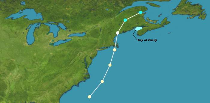 Storm Track for the Saxby GaleAt the same time, an intense low-pressure trough and attendant cold front advanced across New York State, and it would pass New York City around noon of the 4th. The trough and the hurricane appear to converge around the eastern Massachusetts coast in mid afternoon. Analysis of the situation over a century later suggests that the tropical storm, which should have been diminishing in intensity, received an infusion of energy from the extratropical system. This formed a hybrid storm that reintensified in strength as it entered New England waters. On Nantucket Island, the Nantucket Inquirer reported a pressure of 972 mb (28.70 inches Hg) at 3 pm on the 4th and winds shifting from southeast to southwest. At Boston, northwest of Nantucket, the winds backed from northeast to the northwest, an indication that the storm’s center passed between the two sites. At New Bedford, the barometer dropped to 983 mb (29.03 inches Hg) bottoming around 2:15 pm; Boston’s lowest pressure 993 mb (29.34 inches Hg) occurred at 5 pm. Most likely, David Ludlum believed, the storm moved across Martha’s Vineyard and across Cape Cod. Inland Massachusetts weather records mention winds no higher than the Beaufort Force 6 — 40-50 km/h (25-31 mph) — which was observed in southeastern Worcester County. New Bedford reported the “gale was not severe” though stronger than the tropical storm that had passed the region a month earlier. There were no reports of major damage on land at Boston. The greatest winds appear to have blown at sea. Many ship reports speak of full hurricane blasts near the Nantucket Shoals and off Cape Cod. One vessel, the Graham Polly encountered “a hurricane from SE to SW with a tremendous sea; blew away almost an entire suit of sails” about 160 km (100 miles) east of Nantucket. The Great Northeastern Rainstorm and Flood of October 1869While the winds from this storm in Massachusetts, and elsewhere in the United States, were not of great concern, the rains were, thus giving the storm the title of the Great Northeastern Rainstorm and Flood. Beginning in Virginia, the storm dumped at least (five inches)127 mm of rain on ten states: Virginia, Maryland, New Jersey, Pennsylvania, New York, Connecticut, Massachusetts, Vermont, New Hampshire, and Maine. Much of this great wringing of moisture from the atmosphere can be attributed to the interaction of the tropical air with the approaching cold front. Middletown, Connecticut saw 182 mm (7.15 inches) fall in 24 hours, most coming the morning of the 4th. At Canton, Connecticut, the local observer was astonished to measure 311 mm (12.25 inches): “I do not think it could possibly have been so much[;] I think there was an unaccountable mistake.” However, given the accumulation in the area from Hurricane Diane in 1955, Ludlum believed this total was not outside the realm of possibility. At Fitchburg, Massachusetts, about 64 km (40 miles) northwest of Boston, was deluged by 76 mm (three inches) of rain in two and a half hours. At Richmond, Massachusetts, 50 mm (two inches) of rain fell between 8 and 11 am on the 4th. Milton reported 29 mm (1.15 inches); New Bedford, 38 mm (1.51 inches); and Boston, 39 mm (1.52 inches). Further inland, greater rainfalls descended: Lawrence reported 90 mm (3.56 inches) and Mendon, 71 mm (2.80 inches). Reports indicate that the greatest rainfall fell in higher terrain across a band from eastern Connecticut through Springfield, Massachusetts and extending westward into New York’s Hudson Valley. As the day progressed, heavy rains began to fall in New Hampshire and Vermont. Dunbarton, New Hampshire accumulated 108 mm (4.27 inches) in three hours and a storm total of 185 mm (7.28 inches). Goffstown, New Hampshire also received 108 mm (4.27 inches) in the two hours ending at 2 pm. Concord, New Hampshire the deluge totaled 101 mm (four inches) before 2:30 pm. One Maine farmer recorded 210 mm (8.25 inches). The focus of the storm’s fury, however, would be reserved for Maine and New Brunswick, particularly in the Gulf of Maine and Bay of Fundy. On the evening of 4 October, the reintensified storm entered the Gulf of Maine and made landfall along the Maine—New Brunswick border. In transforming from a tropical to a hybrid storm as it moved past Massachusetts, the Saxby Gale’s winds again reached hurricane force, perhaps reaching Category 2 intensity. Though wind impacts were greater than in the other states to the south, rain and subsequent flooding were again the major concern. At Lisbon, Maine, the winds rise from Force 6 to Force 8 (62-74 km/h or 100-119 mph) and 69 mm (2.7 inches) of rain fell. Farther up the Androscoggin River valley in the White Mountain foothills, the accumulated rainfall pushed the Androscoggin rapidly to a stage not reached since the infamous floods of 1832. Virtually every bridge in Maine went out and over a million logs escaped their booms and headed downstream. At Gardiner, Maine (near Augusta), R. H. Gardiner observed the barometer descend to 981 mb (28.99 inches Hg) around 7 pm. At Steuben east of Mt Desert Island, the “wind increased till it blew a perfect gale from about 7 to 8 pm,” according to the local observer. “There never was such a gale hereabouts as this since the country was settled…” Northeastern coastal Maine took the full brunt of the hurricane as it was here that the storm surge produced tremendous tides. At the entrance to the Bay of Fundy, the islands of Deer, Grand Manan, and Campobello all sustained severe damage from wind and tide, as did the communities of Eastport and Calais, Maine and St Andrews, New Brunswick on Passamoquoddy Bay. The Eastport Sentinel reported: “This town was visited by a fearful hurricane last night, vessels, wharves, stores and fish houses were smashed to atoms. …Twenty-seven vessels are ashore in Rumney Bay….The schooner Rio was lost in St. Andrews Bay with all on board—17 in number….Grand Menan [sic] is swept with all its weirs and smoke houses. The towns of Lubec, Pembroke, and Perry lost heavily.” Along the road from Eastport to Calais, a distance of about 50 km (30 miles), at least ninety houses were blown down or severely damaged. The force of the tidal surge can be judged by the crewless voyage of a ship that had been moored at Eastport. The ship, torn from its moorings, drifted across the Coostook Bay and up the St Croix River to Calais where it grounded: a 32-km (20-mile) journey. George A. Boardman, a naturalist on the St Croix River remarked: “Nothing like it ever took place here. It appeared like a whirlwind. It took the roof off my long woodshed, my old store and part of the roof from the barn on the hill. The Universalist church was a perfect wreck; the railroad bridge over the falls in front of my house fell into the river; also the covered bridge at Baring. More than one hundred buildings in St Stephen were ruined…. At Eastport about forty buildings were destroyed or unroofed, several lives lost, and most all of the fishing craft were wrecked…. The blow did not last but about an hour and was heaviest at eight o’clock in the evening…. The wind did not reach very far up the river, only about thirty or forty miles [50-64 km]—in was heaviest about the shores.” The Saxby GaleThe wind increased to gale force in Saint John, New Brunswick on the afternoon of 4 October and rain began falling at 6:00 pm. By 8:30 p.m., the winds blew at hurricane force reaching its maximum velocity at about 9:00 pm. Gusts have been estimated to be in 200 km/h (125 mph) range. As the storm, known in Canada as theSaxby Gale, came ashore, it may still have been a Category 2 event with sustained winds in the 154 to 176 km/hr (96 to 110 mph) range. The gale caused massive forest blowdown that blocked roads and railways with fallen trees and debris and increased the forest fire hazard in the succeeding years. Hundreds of boats were beached due to the high winds all along the Fundy Basin. The first Roman Catholic Church in Cork (near Harvey), New Brunswick, completed in 1861, was blown down by the gale.
Water, however, caused the most concern in New Brunswick and Nova Scotia, but it was not rain as in New England but storm surge as the Saxby Gale raced up the Bay of Fundy on 5 October. The Bay of Fundy is world-renown for its high daily tides. The Gale hit the Bay at the time of the normal high lunar tide, thus adding the storm surge to the high tide, generally the most dangerous situation. And as Saxby had warned, the storm hit when the tide was also peaking due to other influences caused anomalistic, synodical, and tropical monthly cycles, which is known as the Saros cycle. The combined astronomical tide and a two-metre-plus (6.6 ft+) storm surge drove waters in the Bay of Fundy to record heights, the high water mark reaching 21.6 meters (70.9 feet). The waters rose to 16.5 m (54 ft) at the Burncoat Head Lighthouse in Hants County, Nova Scotia. Average normal tides here are the highest tides in the world. Communities such as Maitland, Amherst, Truro, and Great Village, Nova Scotia in the Minas Basin and Sackville and Moncton, New Brunswick up from Chignecto Bay were flooded, though the worst damage occurred in southern New Brunswick and northern Nova Scotia. The storm and storm surge damaged wharves, coastal building, boat and other vessels. 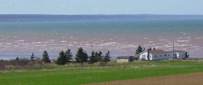 The Minas Basin, Bay of Fundy in early May. |
||||||||||||
 |
Now AvailableThe Field Guide to Natural Phenomena: |
 |
To Purchase Notecard, |
Now Available! Order Today! | |
 |
 |
Now |
The BC Weather Book: |


 In late 1868, Lieutenant Stephen Martin Saxby of the Royal Navy wrote a letter (published on 25 December) to the Standard of London that stated: