There have been deadlier tropical storms. There have been costlier ones as well, but no recorded hurricane or typhoon has had lower central pressure than the supertyphoon (a typhoon with winds exceeding 2401 km/h (150 mph) that roamed the western North Pacific Ocean in October 1979. Tropical storm forecasters designated it Tip, nineteenth tropical storm and twelfth typhoon of the 1979 Pacific typhoon season. Many still consider it the most intense and largest tropical storm since full tropical-storm reconnaissance began in the latter decades of the twentieth century.
Tip fortunately avoided land during its most intense phase. When it did make landfall on the Japanese island of Honshu, its winds still blew at about 130 km/h (80 mph), a category 1 storm on the Saffir-Simpson Hurricane Damage-Potential Scale (SSHS). There, it caused 68 deaths and damage to crops and infrastructure from its heavy rains. But at its peak, meteorologists estimated Tip’s winds to be 305 km/h (190 mph) based on its central pressure of a record low 870 mbar (25.69 inches Hg) as measured by reconnaissance aircraft.
A Storm Is Born
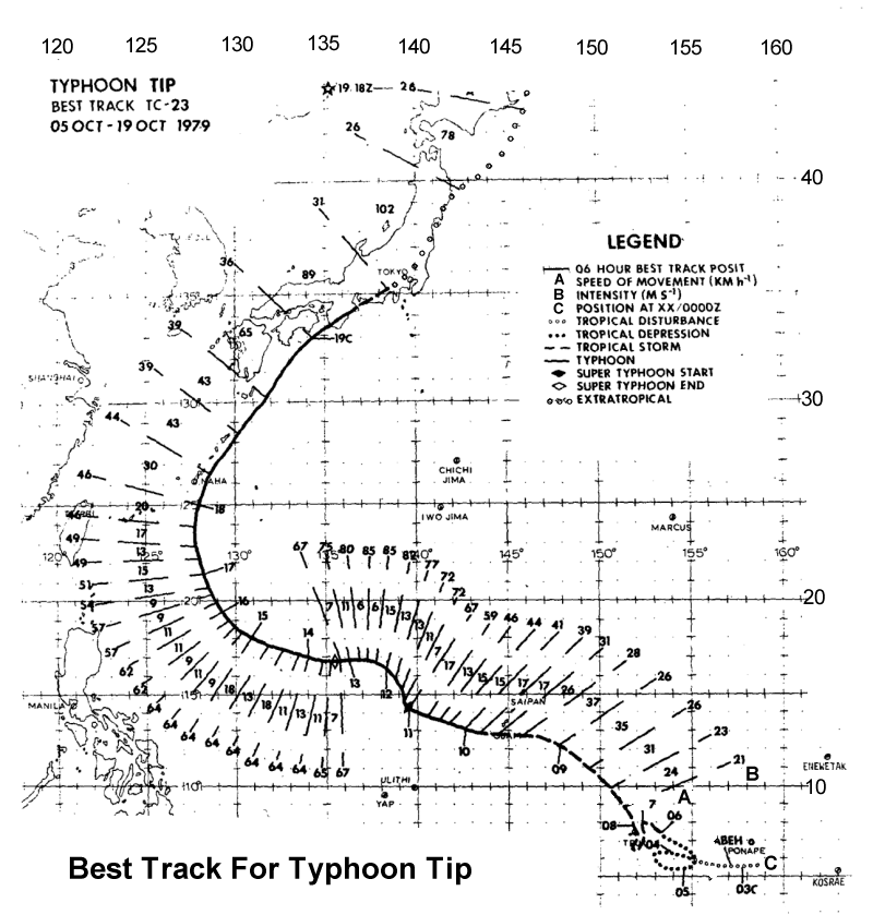
In early October 1979, three tropical circulations could be found within the monsoon trough that spanned the western Pacific from the Philippines’ to the Marshall Islands. One of these, located south of Guam, would become Tropical Storm Roger on 3 October. A second became Typhoon Sarah. The third tropical disturbance near Pohnpei (formerly known as Ponape) in the Caroline Island chain organized into a closed low-level circulation late on 4 October which the Joint Typhoon Weather Center (JTWC) designated as Tropical Depression 23, the following morning. From this time until its eventual dissipation in the north Pacific, the 54th Weather Reconnaissance Squadron out of Andersen Air Force Base in Guam would fly forty aircraft missions into the storm. (For a full storm path diagram, see map at end of this piece.)
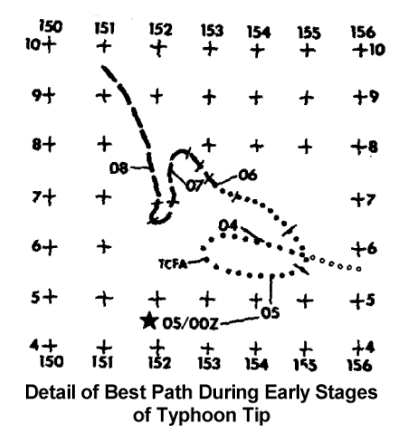
This Depression moved erratically in its first days, executing a loop near the islands of Chuuk (formerly Truk). During this time, the system moved in a broad area of upper level divergence extremely favorable for further storm development that covered much of the western Pacific. On 8 October, Tip, now Tropical Storm Tip, began to move steadily northwestward on course for Guam. But in the early hours of 9 October, the system turned westward, skirting south of Guam by about 45 km (28 mi). As the storm passed Guam, it dropped heavy rainfall totaling 230 mm (9.09 inches) on Andersen Air Force Base.
Erratic path of Tropical Depression/Storm Tip in its first days after formation. Courtesy NOAA
Maturing to a Supertyphoon
Tip’s favorable surrounding environment in the Western Pacific Ocean caused the storm to rapidly intensify. Early in the day of 9 October as it passed south of Guam, Tip became a typhoon, then in less than 24 hours exploded into a supertyphoon, the equivalent of a Category 4 hurricane (SSHS). Its central pressure had dropped an amazing 92 mb in two days (9-11 October) and was still falling. Supertyphoon Tip was now located in the Philippine Sea about 840 km (520 mi) west-northwest of Guam (at 16°44'N, 137°46'E).
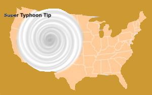
As it grew in intensity, Tip also grew in size, and its circulation pattern (determined by the diameter of the highest closed isobar associated with the storm) was estimated to be 2,174 km (1,350 mi) in diameter on 12 October. This was almost double the previous outer-diameter record set by Typhoon Marge in August 1951. To put this into perspective, if we placed Tip over the United States (see below) with its eye over Colorado, the storm would extend westward to the Pacific Coast and eastward to the western borders of Iowa and Missouri; its north-south extent would span the nation from the Canadian to Mexican borders.
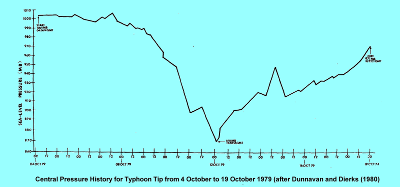
By this time, Supertyphoon Tip’s central pressure had fallen to 870mb (25.69 inches Hg) as measured by a US Air Weather Service reconnaissance aircraft dropsonde early on 12 October. (The onboard sensors measured a pressure of 700 mb (20.67 inches Hg) at a height of 1900 metres.) This reading represents the lowest surface air pressure during a tropical storm ever measured on the planet, breaking the mark set in Supertyphoon June in 1975 by 6 mb (0.18 inches Hg). For comparison, Hurricane Wilma on 19 October 2005 while in the Caribbean Sea had lowest measured pressure in an Atlantic hurricane. Its central pressure, as recorded by dropsonde, was 882 mb (26.05inches Hg).
Tip was also considered at the time the most intense tropical storm ever as estimated by the Dvorak scale, which is based on satellite imagery. Since then, at least two typhoons (Angela in 1995 and Gay in 1992) have had higher Dvorak numbers than Tip.
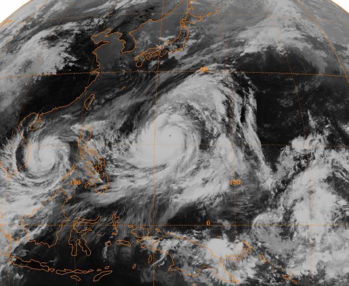
Satellite image of Typhoon Tip near its worldwide record peak intensity, located in the western Pacific Ocean. 12 October 1979 Courtesy GMS-1 Satellite NOAA
At the time of lowest pressure early on 12 October, Tip’s eye was about 15 km (9.3 miles) wide. The Aerial Reconnaissance Weather Officer Captain Patrick Giese on the 12 October reconnaissance mission reported his visual observations in the eye: “…one unusual feature was the spiral striations on the wall cloud. It looked like a double helix spiraling from the base of the wall cloud to the top, making about two revolutions in climbing.”
The reconnaissance aircraft measured Tip’s winds at 305 km/h (190 mph). The tropical storm recognized as having the highest wind speed was Typhoon Nancy in September 1961: 345 km/h (215 mph). However, this figure was obtained by an estimate based on Nancy’s central pressure of 888 mb (26.23 inches Hg). Meteorologists now feel that maximum sustained winds estimated by this method during the 1940s to the 1960s are likely too high. If this is so, Supertyphoon Tip would rate at the top of the wind speed records for Pacific Basin storms, equally the highest winds in the Atlantic Basin storms Hurricane Camille (1969) and Hurricane Allen (1980).
Supertyphoon Tip inspired awe visually as well. Upon returning from a mission on 12 October, Aerial Reconnaissance Weather Officer Lieutenant Carol L. Belt remarked that “…the second penetration was beyond description. This was unquestionably the most awe-inspiring storm I have ever observed. In the 2 ˝ hours that transpired between the first and second fixes, the moon had risen sufficiently to shine into the eye through an 8 nm [nautical mile] clear area at the top of the eyewall. To say it was spectacular is totally inadequate….’awesome’ is a little closer.”
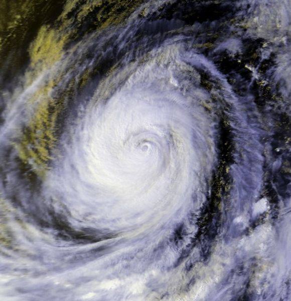
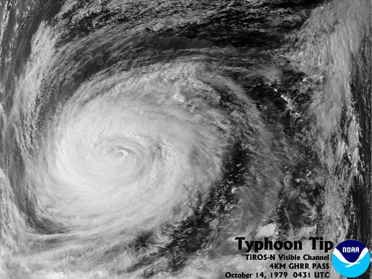
Satellite image of Typhoon Tip. 14 October 1979 Courtesy NOAA
Tip remained a supertyphoon for the next 54 hours as it slowly moved northwestward at between 6 and 13 km/h (4-8 mph). During this period, the radius of winds exceeding gale force (62-74 km/h (39-46 mph)) extended 1100 km (685 mi) from its center on 12 October, the largest area of storminess ever observed (since such observations began in 1945). The winds at the 700mb height from the storm’s eye to a distance of 220 km blew at about 194 km/h (121 mph).
Though Tip would weaken over the next several days from its peak intensity as it drifted west-northwestward, it still packed sustained winds at 230 km/h (145 mph), a Category 4 storm. By 17 October, Tip had begun to weaken and shrink in size. The following day, it changed course, re-curving northeastward under the influence of a mid-level trough.
To Landfall and Dissipation
Passing east of Okinawa, Typhoon Tip’s forward speed accelerated to 75 km/h (46 mph), and Tip headed for Japan, making landfall about 110 km (69 miles) south of Osaka on the main island of Honshu on 19 October. Tip sported winds of about 130 km/h (80 mph) at landfall but rapidly weakened as it rapidly moved across the island, passing north of Tokyo. Although its winds abated, Tip dumped heavy rains across Honshu, causing flooding and mudslides.
While in the northern regions of Honshu, Tip received an influx of cold air and became extratropical. As an extratropical storm, Tip still maintained strong winds at about 90 km/h (~60 mph) for the next two days. Tip continued its path northeastward past the Kamchatka Peninsula, heading toward the Aleutian Islands where it dissipated about 22 October.
Central Pressure History of Typhoon Tip Courtesy NOAA
Impacts of Typhoon Tip
While Typhoon Tip spent most of its fury out at sea, it did have serious consequences upon striking Japan. But before reaching the Japanese coast, Tip dealt blows to shipping along its path, sinking or grounding at least eight ships with a count of 44 fisherman dead or missing. One Chinese freighter broken in two under Tip’s onslaught but fortunately all its 46 crew were rescued.
Tip’s main impact on Japan resulted from its torrential rains and the resultant flash-flooding and mudslides. More than 600 mudslides were reported in the mountainous regions of Honshu. These caused damage to over 22,000 homes. The flooding also broke through river embankments at 70 locations, destroyed 27 bridges and 105 dikes. In the aftermath of the flooding, at least 11,000 were left homeless.
Tip disrupted transportation across the country, grounding 160 domestic airline flights and cancelling 200 train runs. Japanese officials described Typhoon Tip as the most severe storm to strike Japan in 13 years. Fatalities numbered 42 with 71 missing and 283 injured. In addition, the storm caused millions of dollars in damage to the agricultural and fishing industries of the nation.
The storm also had an impact on the US Marine Corps’s Camp Fuji near Yokosuka. Many inside the camp took refuge inside huts at the base of a hill where a fuel farm stood. The heavy rain breached a flood-retention wall, and the waters dislodged hoses from two fuel storage bladders. The released fuel flowed downhill toward the huts where heaters ignited the fuel. The resultant fire killed thirteen Marines and injured another 68. The fire destroyed the barracks, fifteen huts and other structures.
TIROS N Satellite image of Typhoon Tip 14 October 1979 Courtesy e NOAA
Still The Strongest Storm?
Routine aircraft reconnaissance of tropical storms in the Western Pacific basin ended in August 1987, and thus, some tropical storm researchers question whether Tip still remains the strongest tropical storm on record. Using satellite data, researchers believe that Typhoon Gay in 1992 and Typhoon Angela in 1995 likely had higher Dvorak ratings than Tip, and therefore were more intense.
Interestingly, despite Supertyphoon Tip’s place in the meteorological record books, its name was not retired and was used again in 1983, 1986, and 1989. It likely will not resurface as the typhoon-naming scheme has now changed. The likely reasoning the name was not retired is that retirement is usually reserved for storms that have taken a great toll in human lives or caused immense damage. Though a monster storm at sea, its impact on Japan and surrounding nations was no worse than scores of typhoons before and since.
While Typhoon Tip is not a name well recognized by the public, it will remain important to tropical weather researchers as they study the conditions under which this superstorm formed.
Complete Track of Typhoon TIp (courtesy NOAA)
Learn More From These Relevant Books Chosen by The Weather Doctor
For More Weather Doctor articles, go to our Site Map.
I have recently added many of my lifetime collection of photographs and art works to an on-line shop where you can purchase notecards, posters, and greeting cards, etc. of my best images.


 There have been deadlier tropical storms. There have been costlier ones as well, but no recorded hurricane or typhoon has had lower central pressure than the supertyphoon (a typhoon with winds exceeding 2401 km/h (150 mph) that roamed the western North Pacific Ocean in October 1979. Tropical storm forecasters designated it Tip, nineteenth tropical storm and twelfth typhoon of the 1979 Pacific typhoon season. Many still consider it the most intense and largest tropical storm since full tropical-storm reconnaissance began in the latter decades of the twentieth century.