| Home | Welcome | What's New | Site Map | Glossary | Weather Doctor Amazon Store | Book Store | Accolades | Email Us |
 | |||||||||||||||||||||||||||
Weather Almanac for May 2009TOPPING THE MOUNTAINSLife doesn’t always go as planned. I had chosen another topic for this month’s Almanac several months ago, but in early April, life gave me an unwelcomed surprise in the form of a slight stroke. The effects are relatively minor; I do walk like a drunken sailor with the help of my walking stick to push the earth back into kilter. And I have problems swallowing and with feelings in my face and hand, but otherwise, my mind is still sharp as ever. I have done two paintings since returning from a brief hospital stay. I do have less stamina than before the stroke and thus have taken on a gentler topic for this month....in fact, it was inspired by the emergency helicopter trip down the Fraser Valley from Valemount to Prince George. 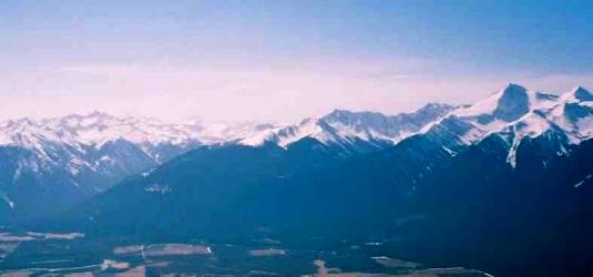 Robson Valley following the Fraser River
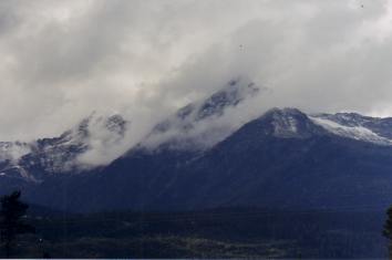
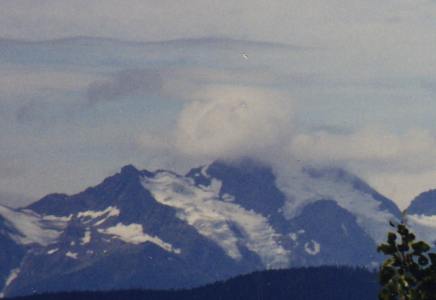
I had hoped to see a few summit clouds, for one project I was to do this spring was to paint the ceiling of the Valemount Museum’s train display room with clouds and fill in some of the clouds along the upper wall where a continuous mountain ridge line around the room has previously been painted. (I am still on for my “Weather Doctor does Michaelangelo” gig though it might be this fall.) Since my mind was on mountain clouds, I decided a short essay on them was the best choice for this Almanac given my lack of stamina. Mountain CloudsClouds form over mountain ridges and summits in several ways. Some form as the result of overriding synoptic-scale weather systems that bring clouds and moisture over mountainous areas. Others form when solar heating of the slopes cause updrafts, and the resultant rising air (remember from Day’s precipitation ladder that a prime ingredient for cloud formation is rising air) forms cumuli or a stratus layer at the condensation level, depending on the atmosphere’s thermal structure. A third mechanism results from mechanically-generated rising air upslope due to pressure gradients and terrain effects. In this latter case, air moving toward a mountain ridge at lower elevation is forced to rise upslope by the topography and then over the ridgeline. In the ascension, the cooling air often reaches the condensation level somewhere near the ridge or summit, and mountain-generated cumulus clouds form. Many times, the cap clouds hug the highest regions and then, when the air descends on the leeside of the ridge, dissipate a distance from the ridge. In other cases, the cloud formation line extends out from the ridge; these are known as banner clouds or lee clouds.
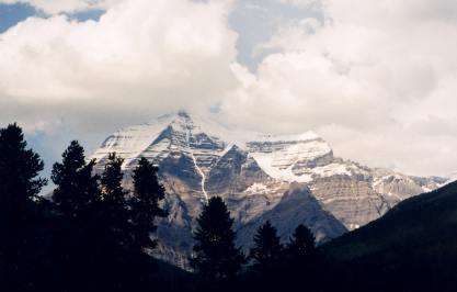
It is not unusual to see mountain clouds forming in air moving over the summits at different elevations. When the overrunning air is pushed to greater heights, condensation of its water vapor may occur in several different layers when the atmosphere there has several layers of differing temperature and humidity. Cap CloudsCap clouds, as the name denotes, look like the mountain peak is wearing a cap. If the cloud region over a summit becomes elongated downwind, the resulting cloud is termed a banner cloud. They form as stated above when the wind ascending a mountain flank reaches the condensation level, which is below the mountain summit. These clouds may form a cumulus-type cloud if the rise in the air continues due to instabilities. Often, however, the cap cloud takes the form of a small, stratus-like cloud with soft edges and little definition within.
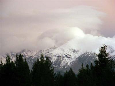
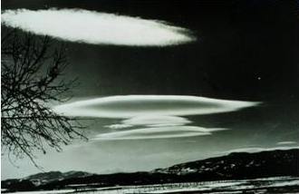
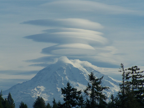
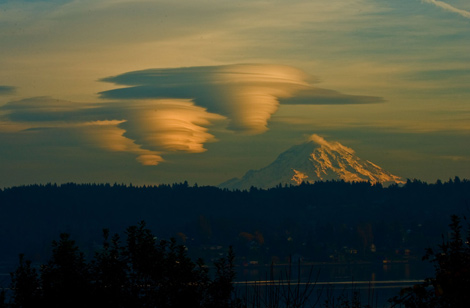
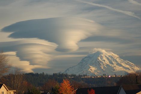
The interesting feature of cap clouds is that they remain fairly stationary over the summit rather than drifting off downwind as the higher clouds in the general synoptic flow above them do. This feature is due to the subsiding of the air on the lee of the summit down to an altitude below the condensation level. The air forming the cloud continues to move, and in effect, the cloud we see is not one cloud but an everchanging one in a constant cycle of rebirth and dissipation. A cap cloud may remain over a summit all day, only dissipating with the ceasing or shifting of the ascending wind. Lenticular CloudsPerhaps the most spectacular of mountain clouds are the lenticular clouds. The technical “species” name for these clouds is lenticular cumulus which can be further defined into altocumulus standing lenticularis, stratocumulus standing lenticularis, and cirrocumulus standing lenticularis. These are similar in formation to the cap cloud, but may form just at the summit or some altitude above. They are characterized by their distinctive shape and strong outline, often showing a layering pattern like a stack of flapjacks. Their name derives from their shape’s resemblance to a lens. They appear in stable atmospheric layers above the mountains which cap their vertical extent.
Like the cap clouds, they do not move from their places over a mountain but are constantly being reborn as the air moves through the region of atmosphere where they reside. 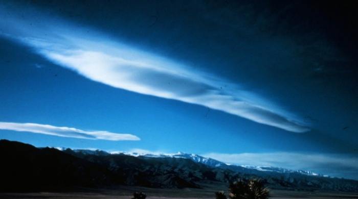 Lenticular Clouds over the Inyo Mountains, California |
|||||||||||||||||||||||||||
 |
 |
 |
|||
Photo by David Embrey |
Photo by Peter Murray |
Photo by Tim Thompson |
One summit that appears to form lenticular clouds of outstanding shape and colors is Mt Rainer near Seattle in Washington State. This volcanic peak stands out among the surrounding summits, as does its neighbors Mt Hood and Mt Baker, Mt St Helens and Mt Shasta.
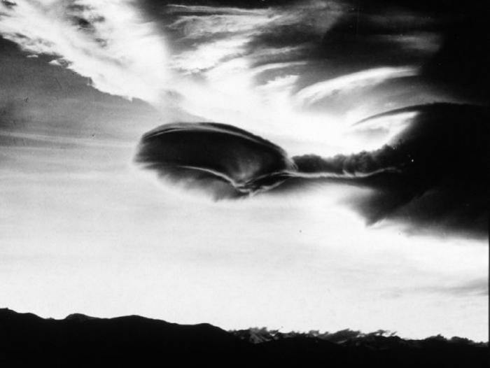
If the airstream moving over a mountain summit rises to its condensation level near the peak and then drops below rather rapidly on the leeside, we see the cap, banner or lenticular formations as singular entities. But at times, when the airstream passes over the ridge/summit, the mountain range acts an obstacle to induce a wave pattern downwind, similar to the standing wave pattern caused by rocks or logs in a water stream.
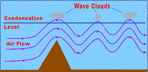
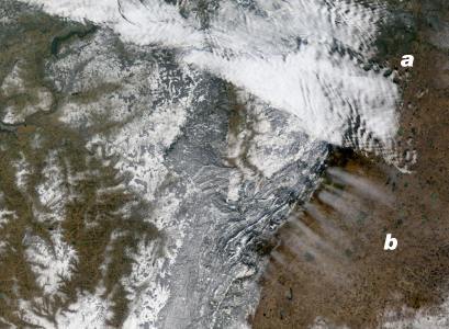
As the diagram above shows, the air moving through the wave pattern rises and falls several times downwind of the ridge line and a series of individual clouds or lines of clouds form in the air. The cloud/line is located in the region of atmosphere where the air rising in the wave crest is above its condensation level while they dissipate as the air descends into the wave trough leaving clear air between the successive clouds. Such clouds are termed lee or wave clouds. Lee/wave clouds can often be caught by satellites as they traverse mountain ridges. In such images, one can readily see the similarity to waves approaching the beach.
My stroke had one positive effect on me. I rediscovered by eye for clouds and through this piece will keep my eyes focused more on the mountain peaks that surround my home. With the warm weather of spring, I will be taking more walks with my eyes to the sky-mountain transition zone. Who knows, perhaps this will improve my painting stroke when I add clouds to my mountainscapes.
 |
To Purchase Notecard, |
Now Available! Order Today! | |
 |
 |
Now |
The BC Weather Book: |


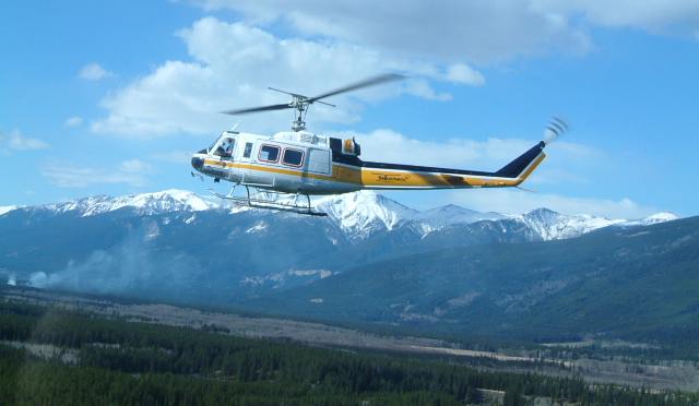 First off, many thanks to the medical attendees and family who got my big hulk into a small helicopter, EMT John Olson and Nurse Sandra Hodge who both attended me during the flight, and to pilot Dale Brady from Yellowhead Helicopters who flew me there. It was a great flight under the circumstances on a clear bright spring morning. The route essentially followed the Yellowhead Highway (Canada Hwy #16) and the northern Fraser River valley, part of which is the beautiful Robson Valley where I reside, between the Rocky Mountains and the Cariboo Mountains. This day, the ridgeline of both ranges was clear of cloud, and their snow-capped heights gleamed in the late morning sun.