| Home | Welcome | What's New | Site Map | Glossary | Weather Doctor Amazon Store | Book Store | Accolades | Email Us |
 | |||||||||||||||||||||||||||||||||||
Weather Almanac for January 2009WINTER TORNADOES
The media were quick to declare these storms a sign of global warming, but the facts are that winter tornadoes — those occurring in the months of December, January and February — have not been that uncommon over the years. This is particularly true in the southeastern United States where hot humid air can blow in from the Gulf of Mexico to meet with cold, dry arctic air and form strong thunderstorms capable of producing tornadoes. In situations such as last year, that meeting point can be well north of the Gulf Coast. A tornado climatology published in 1981 found winter tornado outbreaks comprised nine percent of all major tornado outbreaks between 1950 and 1981. Tornado researchers such as Charles Brooks, research meteorologist at the US National Severe Storms Laboratory (NSSL) in Norman, Oklahoma, believe that winter tornadoes are generally not as strong as their spring/summer counterparts, but can be more deadly. One reason for this is that they are faster moving due to the stronger upper level winds that push the parent thunderstorms at a greater clip than by the high level winds in the warm season. This often reduces warning times between sighting and strike. Another factor which may affect the deadliness of winter tornadoes is that they more often strike in the dark of the shorter days. Winter Tornado FormationThe general picture of tornado formation in the United States during the warm season sees severe thunderstorm development usually during a situation where three different air masses — Continental tropical (cT) which is warm and dry, continental polar (cP) which is cold and dry, and maritime tropical (mT) which is warm and moist — meet in the proper manner. The cP air mass comes from northwestern Canada, the mT from the Gulf of Mexico, and the cT air mass originates in northern Mexico or the US southwest. The peak in the tornado season in the spring and summer is due to the strength of the cT air, which usually disappears by late summer, providing the tinder in the clash between the cP and mT air masses. But in other seasons, tornadoes still form because the polar jet stream plays an important role, and it reaches its velocity peak in the autumn and winter. As a result, the region with greatest tornado likelihood moves with the annual march of the polar jet stream southward in winter and northward in summer. The full picture of tornado formation is still being developed. Recent work by Purdue's Robert "Jeff" Trapp's research team, which includes colleagues at the University of Oklahoma, Colorado State University and NSSL, has found that many tornadoes each year develop within line-shaped storm fronts that often sweep across the country. The twist to this twister tale is that these tornadoes are more likely to form late at night and in colder months between October and March. While it was generally believed that most tornadoes form from spring or summer thunderstorms that develop in the late afternoon or early evening out of isolated, but powerful storm cells, Trapp's study shows that a significant number of tornadoes follow a different path. Their research analyzed 3,828 reported tornadoes in the United States from 1998 to 2000. Though 79 percent of these tornadoes came from cells nationwide, 18 percent came from line storms. "In the heart of Tornado Alley, tornadoes most often develop from relatively small �cell' storms that look like blotches on a Doppler radar weather map," Trapp said. "Over time, these cells frequently merge into line-shaped storms that can stretch hundreds of miles. The conventional wisdom has been that line storms don't often spawn tornadoes, but we found that a significant number did." Further, their study found that these quasi-linear convective system tornadoes had a higher likelihood of forming in the period from January to March and during nighttime hours. The greatest number of such tornadoes occurred in Florida (45), Texas (31) and Louisiana (31). Other recent research suggests that winter tornadoes might be more frequent during La Ni�a winters in a zone from Louisiana to Michigan, including Arkansas, Mississippi and the western portions of Tennessee and Kentucky. The relationship appears to be related to the location of the jet stream. In La Ni�a winters, the jet stream tends to flow from the Pacific Ocean across the Pacific Northwest, then dives southeastward toward the southern Plains and the western Mississippi Valley. Such a path places the areas along the Mississippi River and eastward in a position where warm, moist air at the surface can be overrun by strong jet stream winds aloft thus producing enhanced conditions for tornado formation. Winter Tornado ClimatologyThe work of Trapp, et al, and the deep southern penetration of the polar jet stream give substance to the fact that Florida has two tornado seasons. The first season occurs during the June-September period and is characterized by weaker tornadoes (EF0 or EF1 strength). The second season has been termed the "Deadly Spring Season" and runs from February through April. Tornadoes in this period are more likely to be significant tornadoes (EF2 or greater) and often have deadly consequences for residents of the Sunshine State. 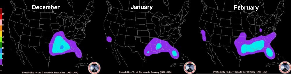 Tornado Probability in US for Winter Months |
|||||||||||||||||||||||||||||||||||
Number of Confirmed Tornadoes in US (1950-2004) | |||
| December | January | February | Annual Total |
| 1011 | 1007 | 1207 | 47076 |
That works out to about two percent of all tornadoes for December and January and 2.5 percent for February, and an average of about 58 winter tornadoes per year.
The most confirmed tornadoes recorded for the winter months for the US as a whole are:
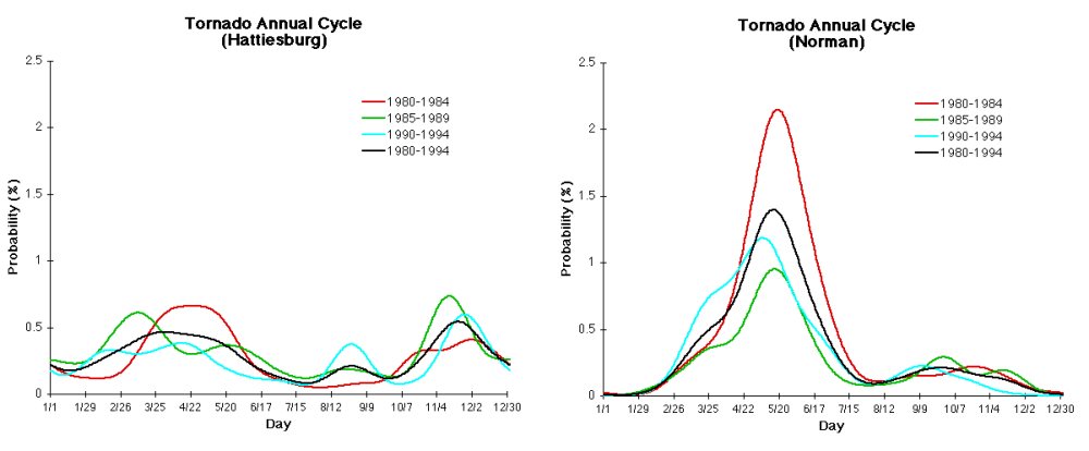
Geographically, the highest percentage of winter tornadoes occurs in the Gulf states from Texas to Florida. The attached graphs show the monthly probability for a tornado to occur within 25 miles of the location for Hattiesburg MS and Norman OK. Note the higher frequency in the winter months for Hattiesburg compared to Norman which is in the heart of Tornado Alley.
The tornado event of 7 January 2008 in Wisconsin was unusual for its northern location at this time of year. These storm were among 71 confirmed tornadoes that struck between 7 and 9 January 2008. Tornadoes were reported across Southwest Missouri, northwest Arkansas, northeast Oklahoma, the Midwest, and the US South. One, which struck south of the Wisconsin�Illinois border in the Illinois counties of Boone and McHenry, injured five. Fortunately, neither of the two tornadoes that struck Wisconsin were deadly. About a dozen people were treated for injuries related to the storm, but none were life-threatening.
 |
 |
 |
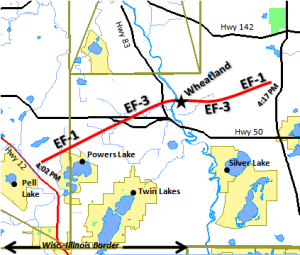
Confirmed Tornado Tracks during 7 January 2008 Outbreak | ||
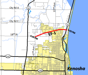
The same storm system also produced two tornadoes in Wisconsin. The strongest tornado in the northern outbreak was an EF3 that struck near Wheatland in Wisconsin. The first tornado spun up in Southeast Walworth County and then tracked through the Wheatland and Brighton areas of Western Kenosha County. Near Highway 50, the tornado reached its widest point, a path width of approximately 200 yards, as it tore through a subdivision just south of the highway. According to local authorities, six to eight homes were severely damaged in the Wheatland area, and an unknown number of cars were blown off the road on Highway 50. Fifteen people were injured. The tornado covered a total of 10.8 miles (17.3 km) in about 15 minutes, which means that its average forward speed as a brisk 43 mph (69 km/h).
The second tornado affected portions of Eastern Kenosha County, including the town of Somers and northern parts of the city of Kenosha and was given an EF-1 rating by the National Weather Service Storm Survey Team. The tornado moved generally to the east-northeast and caused mostly minor damage to homes. There were a few homes with moderate damage, along with some tree and power line damage. Maximum estimated path width is 75 to 100 yards (metres) wide. It was the northernmost January tornado in the US since 1967. No injuries were reported.
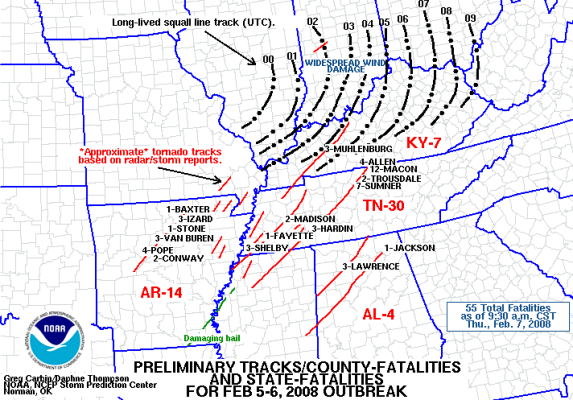
Unfortunately the tornado outbreaks that struck the southern US and lower Ohio Valley on 5 and 6 February 2008 (dubbed by some the Super Tuesday tornado outbreak because of the Presidential Primaries being held that day) were deadly. At least 55 (and as many as 59) died, most in Tennessee, where 31 died, and Arkansas, where 13 perished. The majority of reported tornado activity was seen across Alabama, Georgia, South Carolina and North Carolina. Eighty-seven confirmed tornadoes struck over the course of the outbreak. Tornadoes hit several heavily populated areas in Tennessee: most notably in Jackson, where it hit the dormitories of Union College; in the Memphis metropolitan area; and in the northeastern end of the Nashville metropolitan area. Twenty six of the tornadoes were rated EF2 or greater in magnitude, five of EF4 strength. Harold Brooks commented: "While this is not a normal event, it's not an incredibly rare event."
 |
 |
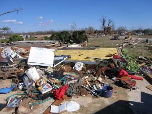 |
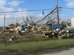
Super Tuesday Tornado Damage |
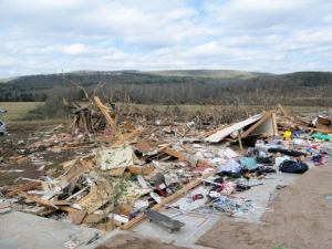
EF3 tornado damage |
Home destroyed by an EF4 tornado |
5-6 February 2008 Super Tuesday Tornado Outbreak | ||
The greatest winter tornado outbreak on record occurred on 21-22 January 1999 when 134 tornadoes left nine dead. The storms raked the states of Arkansas and Tennessee. This outbreak came on the heels of a smaller outbreak in the same general region on 17 January which struck Mississippi, Arkansas and Tennessee.
The deadliest winter outbreaks on record prior to 1900 occurred on 19-20 February 1884. Called the "Enigma Outbreak," the tornadoes took an estimated 167-178 lives and injured an estimated 1200, though the precise number of casualties and tornadoes are unknown. Published contemporary accounts suggest more than forty tornadoes struck across the states of Alabama, Mississippi, Georgia, Tennessee, Kentucky, Illinois, Indiana, North Carolina, South Carolina, and Virginia. Some of these may have actually been multiple reports of a single tornado or damage due downbursts rather than tornadoes, but perhaps other funnels were missed. The outbreak was studied by early tornado researcher John Parks Finley.
A perusal of the Wikipedia list of notable American tornadoes and tornado outbreaks from 1890 to 2008 identifies 29 winter events of note. A significant tornado is considered one which is rated F2 or EF2 on the Fujita Scales.
The St Louis Missouri metropolitan area has been hit at least three times by winter tornadoes: January 1890, February 1959 and January 1967.
The deadliest outbreak of the twentieth century struck the Southern Mississippi Valley on 21 February 1971: 119 were reported dead under the onslaught of 14 tornadoes of which four were F4 or greater.
An outbreak occurred at Christmas in 1982 (23-25 December) across the central southeastern US. Eighteen significant tornadoes took three lives. On New Year's Eve 1947, winter tornadoes racked the southern US taking 20 lives.
The 24 January tornado outbreak in 1967 recorded 20 significant tornadoes and seven fatalities across the Midwest, hitting the states of Iowa, Missouri, Illinois, and Wisconsin. The northernmost tornado of the group hit between Brodhead and Milton (Green/Rock Counties), Wisconsin. That F2 storm destroyed some barns.
The northernmost significant winter tornado in the US, and North America, that I could find in the records occurred in Wisconsin on 1 December 1970. The F2 tornado moved from Medina (north of Appleton) in Outagamie County to southeastern Shawano County and destroyed 20 barns and five homes along its 30-mile (50 km) path.
There have been two winter tornadoes reported in Canada. On 30 January 1954, a tornado touched down at White Point Beach near Liverpool, Nova Scotia. The only other tornado to strike during winter in Canadian annuals hit the Ontario community of Exeter (north of London, west of Stratford) on 12 December 1946. Another almost made it to winter, striking Leamington, Ontario on 29 November 1919.
 |
To Purchase Notecard, |
Now Available! Order Today! | |
 |
 |
Now |
The BC Weather Book: |


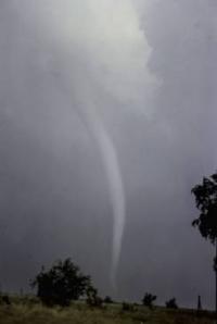 With the beginning of a new year, most North Americans' severe weather thoughts turn to blizzards and ice storms. We do not think about the possibility of a tornado, particularly north of the Ohio Valley in the eastern US and Missouri Valley in the west. But one year ago, on 7 January 2008, a rather rare winter tornado touched down near Kenosha, Wisconsin. Just a month later, a swarm of killer tornadoes struck the Mid-South US.