| Home | Welcome | What's New | Site Map | Glossary | Weather Doctor Amazon Store | Book Store | Accolades | Email Us |
 | |||||||||||||||||||||||||||||||||||||
Weather Almanac for February 2009FREEZING AMERICA: THE COLD WAVE OF 1899The major cold snap of mid-January 2009 that covered much of North America east of the Rockies, dropped temperatures as low as 48°F (8.9° C) in Key West, Florida and below -40°F/C in Manitoba, the Dakotas and Minnesota. At Babbitt, Minnesota, the thermometer bottomed out at -48 °F (-44.4° C) on the morning of 14 January. To the north, in Manitoba, Canada the temperature sunk to -45°F (-43° C) at Sprague. These cold temperatures followed a period of intense cold in Alaska and the Yukon, where in the Alaskan community of Stevens Village, the cold reached -60°F (-51.1° C) on 7 January. While this cold was indeed extreme, it did not match the bitter cold which encompassed much of the continent in the first half of February 1899, reaching its peak from the 10th to the 14th. Many cities still have not broken the minimum temperature records set during that period, and for four of the twelve American states that set record cold at the time, February 1899 still holds the state record for cold. Ice chocked the Mississippi River, and some flowed into the Gulf of Mexico. Every state in the Union, as well as the Canadian provinces, dropped below 0°F (-18° C) on at least one occasion. Tallahassee, Florida saw the temperature fall to -2°F (-18.9° C) on 14 February, the coldest temperature ever recorded in the Sunshine State, though unofficial measurements suggest the state low that day was -4°F (-20° C). In addition to the deadly cold, a blizzard raged over the US East Coast bringing more than 3 feet (90 cm) of snow to Philadelphia, New York City, New Jersey and New England. Snow drifting to 20 feet (6.1 metres) across the Chesapeake and Potomac Valley. Note: I will use the Fahrenheit Temperature Scale in the main body of this article as it was the unit for temperature in the US and Canada at the time. I will also refer to locations based on the current roster of US states and Canadian provinces, though several in the American West and Canadian Prairies had not yet reached that official status. The Beginnings
Boise, Idaho saw a -9°F (-23° C) reading on the 4th. Idaho Falls, Idaho shivered at -29°F (-33.9° C) on the 5th, but Idaho�s low of-41°F (-40.6° C) was measured at Lost River. Utah recorded a low of -50°F (-45.6° C) at Woodruff on the 6th, with Salt Lake City bottoming out at -10°F (-23.3° C) the same day. Nevada reported its month low temperature at -27°F (-32.8° C) at Wells on the 5th. Cheyenne, Wyoming chilled to -28°F (-33.3° C) on the 6th. Wyoming reported its month�s low at -51°F (-46.1° C) at both Lowell on the 4th and at Basin the next morning. This frigid arctic airmass was drawn southward by a storm system which moved in off the Pacific at the Oregon coast and slipped southeastward over the Great Basin toward southwest Texas in the following days. By the 4 February, the cold air reached the southern tier of states from California to the Carolinas. The cold gave Truckee, California a month�s low temperature of -21°F (-29.4° C), and a -30°F (-34.4° C) reading at Boca, California was the state�s coldest temperature. Even Southern California was not immune to the cold. In Los Angeles, the mercury dipped to 33°F (1° C)) on the 4th, and San Diego slipped to 34°F (1.1° C) on the 6th. In the desert Southwest, Flagstaff (Arizona) shivered at � 21°F (-29.4° C) on the 6th, while Phoenix, Arizona dipped to 24°F (-4.4° C) and Santa Fe, New Mexico to -5°F (-20.6° C), the latter two on the 7th. The coldest in Arizona was -24°F (-31.1° C) at Fort Defiance and in New Mexico, -27°F (-32.8° C) at Windsors, both experienced on the 7th. El Paso in southwest Texas recored a +5°F (-15° C) minimum on the 7th. Meanwhile, a second and colder airmass was forming in the arctic which by the 7th lay over the Canadian Prairies (Saskatchewan, western Manitoba and eastern Alberta) with a central pressure 0f 1045 mb (30.86 inches Hg) at Swift Current, Saskatchewan. The temperature at Minnedosa, Manitoba that morning hit -43°F (-41.7° C) , the first of four straight mornings with temperatures below -40°F/C) (the coldest at -50°F (-45.6° C) on the 9th); Battleford, Saskatchewan plunged to -37°F (-38.3° C) and Winnipeg, Manitoba hit -38°F (-38.9° C). The airmass moved southward beginning on 7 February as a strong storm system formed from a trough of low pressure over Georgia and along the US southeast coast. This storm would rapidly move into New England on the 8th and the Canadian Maritimes the following day. 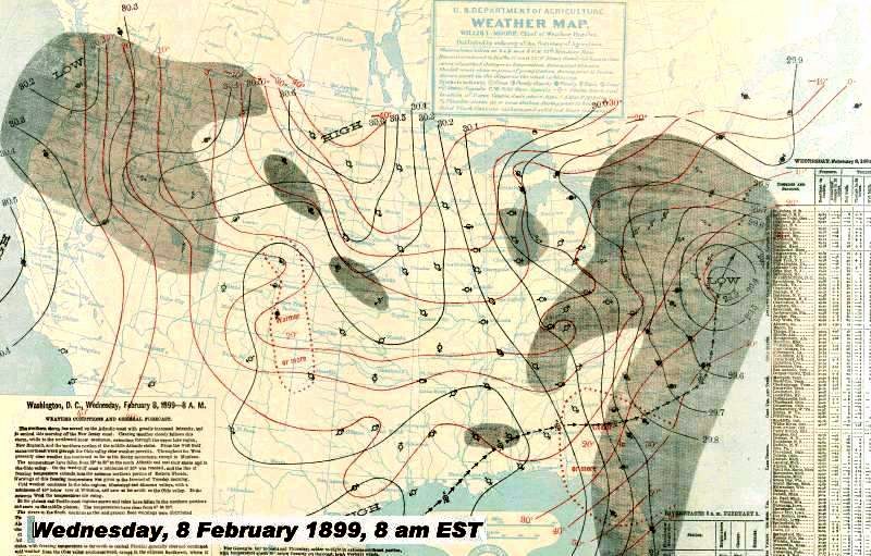 This storm dumped moderate to heavy snows over the Northeastern US: 6-10 inches (15-25 cm) over much of the heavily populated cities including New York City and Boston, Massachusetts. Away from the coast and further north in excess of 10 inches (25 cm) fell. Northfield, Vermont accumulated 15 inches (38 cm) and 10.7 inches (27.2 cm) covered Binghampton, New York. Further south, the snow from this and two previous storms had accumulated 14 inches (35.6 cm) in Washington DC. 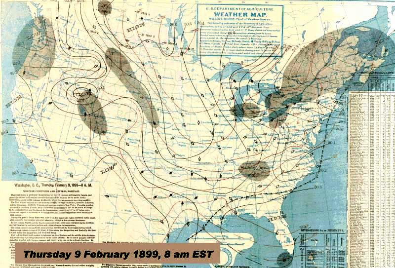 Behind this storm system, the Canadian arctic airmass spilled into the Great Plains and flowed southeastward toward the Gulf Coast. Its central pressure on the 8th registered 1040 mb (30.71 inches Hg) in southeastern Saskatchewan where Battleford reported a low temperature of -46°F (-43.3° C). Meanwhile Winnipeg, Manitoba plunged further into the cold with a -47°F (-43.9 reading on the 8th. The morning temperatures in the Dakotas and Minnesota which had been in the minus 30°F (-34.4° C) range dropped further to the -40s (°F/C). As the cold seeped south and eastward, sub-zero Fahrenheit (<-18° C) temperatures extended as far south as Kansas, Missouri and the Ohio Valley. By the morning of the 9th, temperature readings sunk below 0°F (-18° C) north of a line extending from Oklahoma to Virginia and covered nearly half the nation. The Dakotas, Minnesota and Wisconsin each reported lows below -30°F (-34.4° C). Chicago, Illinois shivered at -21°F (-29.4° C) while just to the north in Milwaukee, Wisconsin, the temperature bottomed at -22°F (-30° C). Cincinnati, Ohio set a record low of -17°F (-27.2° C) that would stand for 78 years. States west of the Rockies that recorded their month�s lowest temperature during February before the 10th included:
10-14 February: The Main Event10 February, FridayOn the heels of this cold arctic airmass there lurked an even colder one. On the morning of the 10th, it began pushing extremely cold air across the US-Canada border from the Canadian Prairies. The highest pressure of this airmass registered 1055 mb (31.16 inches Hg), and it was still building. Temperatures in the Canadian Prairies hovered between � 41°F (-40.6° C) at Battleford, Saskatchewan to -44°F (-42.2° C) at Minnedosa, Manitoba. Edmonton, Alberta and Winnipeg, Manitoba both reported a low of -42°F (-41.1° C) on this day. The coldest temperature north of the border was reported at -54°F (-47.8° C) at White River, Ontario, an area known for cold temperatures as the community lay in good topography for cold air drainage and accumulation. 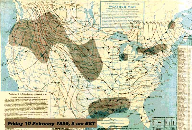 Early morning lows at several stations established the maximum depth of the cold waves for the month: Easton, Wisconsin froze at -50°F (-45.6° C); Milligan, Ohio plunged to -39°F (-39.4° C);Drayton, West Virginia shivered at -35°F (-37.2° C) while Parkersburg, West Virginia set its all-time low at -33°F (-36.1° C); Monterey, Virginia bottomed at -29°F (-33.9° C); Sunnyside, Maryland sunk to -26°F (-32.2° C); Deckertown, New Jersey reported -17 °F (-27.2° C). Only Florida escaped freezing temperatures with Key West registering a low of 60°F (15.6° C) and Jacksonville, 42°F (5.6° C). In New England, the cold was intensified by winds blowing at over 20 mph (32 km/h). The Gulf Coast states were reporting light snow and rain north of a cold front hovering over Gulf waters; snow accumulated to an inch or more in parts of Alabama, Louisiana and Mississippi. Further north, a second cold front lay across the upper Plains states. Ahead of the front the temperatures ranged from -25°F (-31.7° C) to -35°F (-37.2° C) while north of it, temperatures were typically below -40°F (-40° C). By evening, this front had slumped to the south and extended from Texas in the west to Illinois in the east. Moderate to heavy snow fell to the west in Wyoming, eastern Kansas and western Missouri, behind the snow region, the temperatures again began to plummet ushered in on northwesterly winds blowing at over 20 mph (32 km/h). The combination of wind and cold pushed wind chill values (old style formula) to as low as -100°F (-73° C). By evening, this new high-pressure cell sported a pressure of 1060 mb; a giant even when compared to the 1038 mb (30.66 inches Hg) high located over the Ohio Valley. And by the morning of the 11th, its central pressure as measured at Swift Current, Saskatchewan (Assiniboia) increased further to 1064 mb (31.42 inch Hg). 11 February, SaturdayAs 11 February dawned, the eastern high pressure cell (maximum pressure 1040 mb) had drifted from the Ohio Valley to off continent at the Mid-Atlantic states. Under clear skies and with light winds, the temperature dropped in Washington DC to -15°F (-26.1° C), the coldest temperature in that city since the end of the Civil War. (A reading of -16°F (-26.7° C) had been recorded in 1835.) In outlying areas around the Capitol, reports put the low temperature as cold as -25°F (-31.7° C). 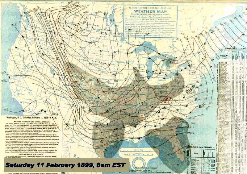 That morning, the coldest temperature in the February cold-waves was recorded in Montana, -61°F (-51.7° C) at Fort Logan. Other state low temperatures for the month were reported from Pennsylvania, -39°F (--39.4° C) at Lawrenceville; in Kentucky, -33°F (-36.1° C) at Sandyhook; in New York, -31°F (-35° C) at Number Four. Elsewhere, extreme cold saw Miles City, Montana plummeted to -47°F (-43.9° C). Huron, South Dakota registered -36°F (-37.8° C) while Rapid City, South Dakota fell to -34°F (-36.7° C). In Minnesota, Duluth dropped to -32°F (-35.6° C) as did La Crosse, Wisconsin. Wichita Kansas plunged to -22°F (-30° C), which still remains the city�s coldest day on record. At Topeka, Kansas, the noontime temperature stood at a numbing -18°F (-27.8° C). During the day, moderate to heavy snow fell ahead of the surging cold from southeastern Missouri through Indiana, Illinois and Kentucky, accumulating as much as 6 inches (15 cm). Along the southeast Atlantic Coast, a second trough of low pressure with associated fronts formed, bringing light rain and ice pellets to South Carolina and Georgia. The cold across the Plains did not abate with the daylight. Havre, Montana shivered to a high of -26°F (-32.2° C); Williston, North Dakota warmed only to -18°F (-27.8° C) and St Paul, Minnesota struggled to -10°F (-23.3° C). By the evening, the sprawling high pressure cell stretched from Wyoming across the Plains and into the Great Lakes and south through Texas into the lower Mississippi Valley; its maximum pressure on the US side at 1058 mb. The zero°F (-18° C) isotherm pushing into Oklahoma, Texas and Arkansas on a blue norther. The region of snowfall ahead of this cold air now reached the Atlantic Coast from the Ohio Valley. Cape Hatteras, North Carolina reported snow falling for much of the day with an accumulation of 3-4 inches (7.10 cm) before changing to rain as temperatures moderated with a wind shift from northeast to southeast. The late night temperature soared to 52°F (11.1° C) indicating air from offshore had moved inland to west of Hatteras. This brief warming was the result of a weak system forming off the Carolina coast. Further west and north from the low center, light snow fell in Virginia and Maryland and a mix of frozen precipitation fell from the Carolinas to Georgia. A second area of low pressure located over the northwestern Gulf of Mexico brought light rain, snow and ice pellets across the Gulf Coast from Texas to the Florida Panhandle. At the coast, temperatures remained above freezing for most of the day but would plummet when the leading edge of the intense cold airmass moved offshore. Foreseeing the advance of the frigid temperatures across the State of Florida, the Jacksonville Weather Office issued cold wave warnings across the state. According to Local Forecast Official A.J. Mitchell, �Railroads notified fruit and vegetable growers along their lines, cold wave and frost signals were sounded by locomotives and river steamers, and along the 400 lines of the Florida Coast Line every section was properly served.� 12 February, SundaySunday morning, 12 February would begin the two-coldest days in the long cold wave across much of th US east of the Rockies. The center of the cold high pressure cell stood over Oklahoma, its pressure at 1052 mb. Most of the coldest temperatures could be found west of the Mississippi from Nebraska to Texas. 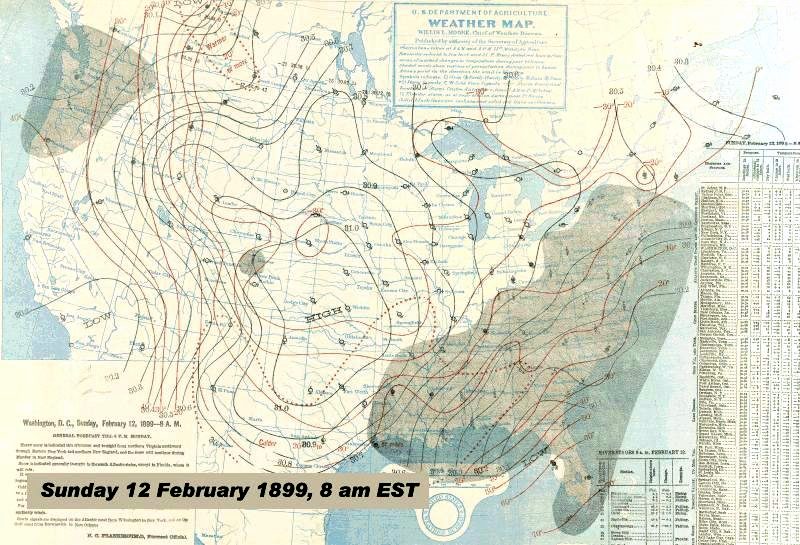 Lowest state temperatures for the cold waves occurred this day for:
Cities setting record minima that still stand include:
The cold in Texas brought more to the state than just cold temperatures. Reports from areas west of Galveston indicated that the bay had frozen completely over from the barrier island to the mainland. North of Corpus Christi, the Nueces River froze �hard enough to pass over.� according to local reports. Newspapers across the Lone Star State reported the cold was the worst freeze ever known at least as far back as 1832, and some claimed it was the coldest since the arrival of Anglos in the territory. With the advance of the cold air over the central Gulf Coast, snow, blowing snow and temperatures in the teens (Fahrenheit) worried residents of New Orleans, Louisiana and Mobile, Alabama. Pensacola, Florida accumulated 2-3 inches (5-7.5 cm) of snow, blown and drifted by fierce northerly winds. Heavy snow now fell across central Alabama and northern Georgia, extending into the western Carolinas. The low pressure cell which had formed in the western Gulf of Mexico moved to south of Louisiana by Sunday morning and off the Georgia-South Carolina coast by evening. It was in full development and strengthening as the day progressed. Its central pressure falling from 1016 mb (30.00 inches Hg) on the evening of the 11th to 1008 mb (29.77 inches Hg), 24 hours later. It would soon develop into a major nor�easter blizzard. During the day, snow fell from Louisiana east to Florida and northward along the Atlantic coast to central New England with accumulations of 4-8 inches (10-20 cm) general across the swath. Winds strengthened as the gradient between the storm and the cold high to the west increased. The blast was enhanced by frigid temperatures (0 to 10°F (-18-12.2° C)) in many areas of the South. By evening, the core of the cold air lay over Missouri and Illinois with the center of the high over Texas, its central pressure now down to 1046 mb. As the night wore on, the temperatures in the southeastern states were dropping to their lowest levels of the cold wave. Daytime temperatures in the South had held in the teens (Fahrenheit) and the snow now on the ground assisted the nocturnal drop in temperature. As much as 6-8 inches (15-20 cm) of snow lay on the ground in Alabama and Georgia, and it continued to fall up the coast from eastern Georgia to southern New England, the heaviest snows now falling inland through the Carolinas to southeast Virginia. 13 February, MondayDuring the night, the coastal storm system underwent explosive growth, a bomb cyclone in today�s terminology. Indeed, it may have been a superbomb, the central pressure falling more than 20 mb (0.59 inches Hg) in a 12-hour period to 984 mb (29.06 inches Hg). (A bomb cyclone is one whose central pressure falls by 24 mb (0.71 inches Hg) in 24 hours.) With the intensification in storm strength, there was a concurrent intensification of the snowfall rate. Heavy snow now fell from the Carolinas northward into New England producing severe blizzard conditions over most of the affected area as the falling snow was blown by high winds. The Carolinas added more than 10 inches (25 cm) of new snow in some localities. 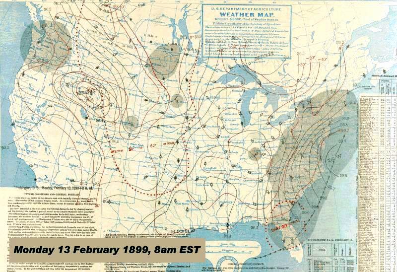 When the sun rose this morning, Jacksonville, Florida had received its heaviest accumulation of snowfall, 1.9 inches (5 cm) covering the ground. Measurable snow (>0.1 inch / 0.25 cm) lay across the Sunshine State as far south as Lakeland and Tampa. A trace of snow fell at Fort Myers, the southernmost snowfall in Florida until January 1977. The most snow fell in Hayward, 3.5 inches (8.8 cm) while Lake City measured 3 inches (7.5 cm) of the white. The snow falling on Tampa may have been �Gulf-effect� snow produced when the frigidly cold air streamed across the Gulf of Mexico and onto the Florida shoreline. The storm system pulled the frigid arctic air in its wake. The cold set records in the Southern States. Florida�s coldest day ever -2°F (-18.9° C) was registered at Tallahassee, and still stands. Atlanta, Georgia shivered at -9°F (-22.8° C);while Diamond and Tallapoosa at -16°F (-26.7° C) shared the distinction as Georgia�s coldest spot. Montgomery, Alabama sunk to -5°F (-20.6° C) while Mobile was a degree below the Fahrenheit zero mark (-18.3° C), breaking the city�s old minimum temperature record by a staggering 18 F deg (10 C deg). However, Alabama�s coldest spot was at Valleyhead, a numbing -17°F (-27.2° C). New Orleans, Louisiana suffered its coldest day ever at 7°F (-13.9° C) as did Shreveport at -5°F (-20.6° C), but the coldest place in Louisiana, Minden, registered a -16°F (-26.7° C) temperature. In Mississippi, French Camp was the cold spot this day at -16°F (-26.7° C). The cold air also moved out from the US bringing cold temperatures to parts of Mexico and the Caribbean Islands. Cuba in particular was hard hit. The morning temperature in Havana fell to 54°F (12.2° C) by evening under rain and wind. The frontal storm sported northerly winds as high as 36 mph (58 km/h) which caused water levels to increase, washing away several houses on the coast. At Santiago, the norther arrived around 5 pm dropping the temperature to 62°F (16.7° C) by 3 am on the 14th. The norther brought blustery winds and very cool temperatures across other islands of the Caribbean. Stations noting such drops on the 13th and 14th included San Juan, Puerto Rico, Kingston, Port Antonio and Montego Bay, Jamaica, Bridgetown, Barbados, and in Central America at Colon, Columbia. The cold was not confined to the Southern States by any means. Keesees Ferry tied Arkansas� mark for coldest day during the period with a �25°F (-31.7° C). Indiana reported its coldest morning of the month with a -29°F (-33.9° C) reading; while Missouri had its coldest day, -32°F (-35.6° C) at both Birchtree and Zeitonia. In North Carolina, Highlands registered the state�s coldest day of the period with a -19°F (-28.3° C) reading. In Tennessee, the cold wave�s coldest hit Erasmus with a -30°F (-34.4° C) temperature. As the day progressed, the coastal storm system continued its run up the Atlantic Coast reaching near Nantucket, Massachusetts by 8 pm EST, its central pressure now 966 mb. Raging blizzards savaged the Atlantic coast from the Mid-Atlantic States to New England. Twenty new inches (50.8 cm) of snow had accumulated in Washington DC by 7 pm, and Baltimore, Maryland had received over 30 inches (75 cm). Many localities in North Carolina, Virginia, Maryland and southern New Jersey measured over 20 inches (50.8 cm) of new snow. Cape May, New Jersey topping the list with 34 inches (86.4 cm). By day�s end, many areas now had received 30 to 40 inches (75-100 cm) of snow since the month began...and it was not yet over. 14 February, TuesdayThe storm system continued its rapid trek northeastward and was over Nova Scotia by Tuesday morning. In its wake, snow accumulations of 10 to 20 inches (25-50 cm) were common over much of New Jersey, eastern Pennsylvania, southeast New York and southern New England. In some areas, snowfalls exceeded 20 inches (50 cm). Overnight, Baltimore�s snowfall accumulation reach 21.4 inches (54.4 cm), Washington DC, 21.0 inches (53.3 cm). Philadelphia had received 18.9 inches (48 cm) while New York City collected 15.5 inches (39.4 cm). Bostonians saw 16 inches (40.6 cm) of new snow on the ground. 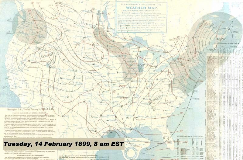 The cold had moderated some from previous days, but many areas still shivered under temperatures below zero°F (-18° C), particularly in portions of the Middle Atlantic states and the Ohio Valley. Most of Florida saw sub-freezing temperatures; only Key West escaping the full brunt of the cold with a balmy 44°F (-42.2° C) low temperature. Columbia, South Carolina and Raleigh, North Carolina both reported a low of -2°F (-18.9° C), and Augusta, Georgia measured +3°F (-16.1° C). Back in Michigan, Grand Rapids saw the thermometer register a -24°F (-31.1° C) minimum. However, South Carolina was the only state to record its coldest day of the cold waves on the 14th, -11°F (-23.9° C) observations at both Santuc and Shaws Forks. In the American Heartland, the temperatures showed signs of recovery from the bitter cold. Much of the Mississippi Valley showed temperatures 20-30 F deg (11-17 C deg) higher than the the previous morning. Sioux City and Des Moines, Iowa recorded highs above the freezing mark as did Bismark, North Dakota and Omaha, Nebraska. 15 February, WednesdayBoth the coastal low and arctic high continued their treks eastward. The low passed Newfoundland before heading into the North Atlantic. The high pressure cell that had frozen the eastern US had now moved off the coast by the 15th and the return flow on its western side, temperatures began to return to normal. Only one state reported a minimum temperature this day as its coldest for the month: New Jersey which tied its lowest reading of the month when Riverdale reported a low of -17°F (-27.2° C). (Deckertown had also reached that temperature on the 10th.) Much of the Plains and parts of the Midwest and South saw morning temperatures jump by 10-30 F degrees (8.5-17 C deg) over those of the previous day. Jupiter, Florida saw its 8 am morning temperature soar from 30°F (-1.1° C) on the 14th to 64°F (17.8° C), a temperature higher than the previous day�s high (58°F (-14.4° C)). With the exit of the arctic high, the great cold waves of February 1899 came to an end. ImpactsThe intense cold and snow produced major impacts on the population, its infrastructure and agriculture. A contemporary newspaper account cried: �Loss of lives, livestock, and crops was enormous.� What the human toll from the cold and blizzards actually was will never be fully known, but the US Weather Bureau reports put the number of fatalities between 29 January and 13 February due to cold and avalanches in Colorado at 105. The fatality distribution by state was:
The death of wildlife and livestock due to the cold was incalculable. F.P. Chaffee of the Alabama Climate and Crop Service office reported: �stock suffered very much; in some counties cows, hogs and goats froze to death and poultry froze on the roost.� Similar reports of damage and destruction of fruit trees and crops were widespread across the South. The Georgia peach crop was totally destroyed in some areas and heavily damaged in others. Many young trees were killed by the cold. The damage would have been greater, but in many areas, timely forecasts of the advancing cold and warnings issued by the Weather Bureau allowed farmers, ranchers and orchardists to take protective measures for their crops and livestock. One in particular saved Mr Max Beer of North Platte, Nebraska, $5,000. Beer had 200 cows and calves on cars and on the road but removed them to safer locations on hearing the warnings. The local temperature fell to 35 below zeroF that night. From across the nation came reports of snow-bound trains, ice blocking port and dock facilities, interrupted communication, and shortages of food and fuel. Schools were closed and normal life in both city and countryside were �greatly deranged,� particularly for the poor. According to the review by Alfred Henry in Monthly Weather Review: �Undoubtedly the greatest financial loss fell upon shipping and stock raising interests.� He noted: �The loss of livestock on the plains and in the great grazing States is not known, but it must have been large by reason of the depth of snow and the duration of the low temperatures.� In Chicago, the lack of a snow cover allowed the frost to penetrate the soil to a depth of five feet, causing great damage to water, gas and service pipes,.Some plumbers used a novel method to thaw the frozen pipes: an electrical current. On Lake Michigan, several steamboats were frozen out of port for three to four days. The great freeze caused numerous areas of flooding as ice jams formed on the Ohio, James, Tennessee, and Cumberland Rivers as well as many streams and tributaries. Many swift flowing streams in the South iced over, and great numbers of fish died from the extreme cold water. The Mississippi River remained frozen from its source to below Hannibal, Missouri for the entire month. Ice cover reached Cairo, Illinois by the 7th. Railroad ferryboats tried to keep the river open to navigation to the mouth of the Ohio River, but gave up on the 7th when the ice became solid, suspending navigation until the 21st. On the 13th, the ice at Cairo reached 13 inches (33 cm) thick. The ice closed navigation on the Mississippi at Memphis, Tennessee on the 10th, damaging some boats in the harbor and sinking two. The ice cover extended to Greenville, Mississippi on the 11th and Vicksburg, Mississippi the next day. All navigation on the river was suspended on the 13th. At the peak of the cold spell, ice could be found throughout the entire Mississippi watershed, with the river frozen solid south to Cairo. On 17 February, the ice, measuring 2 inches (5 cm) thick, reached New Orleans and flowed out into the Gulf of Mexico two days later. Ice an inch (2.5 cm) thick was observed at the mouth of the river. The cold spell gave us examples that some things don�t change over a century. The West Virginia Daily Oil Review reported �The plumber is the most popular man in town today, and for once the individual who is lucky enough to secure his services does not object to his bill. The price for coal, for home heating, started to climb from $1.50 a ton to $2.00 a ton during the cold wave, but the week-long onslaught was not long enough for coal shortages to develop.� But there were positive moments too as the snow and cold allowed three days of sleigh-riding in Montgomery, Alabama where ice was thick enough on the ponds for skating. An Albany, NY newspaper wrote that the local ice business received a bonanza from the cold: �All [the ice] was cut that could be handled, and the crop was unexcelled both as to quality and quantity.� A South Carolina paper rejoiced that, �The yellow fever...slained [sic] by the cold.� During the depths of the cold, there were numerous reports of auroral displays on the 11th-13th: 85. Most came from the Dakotas, Minnesota, Iowa and Michigan. AftermathIn the following weeks, temperatures would soar over much of the US east of the Rockies. Compared to climatic normals they were as much as 10 to 35 F deg (5.6 to 19.4 C deg) above during the period of 19-22 February across the Plains, Ohio Valley and East Coast. In some cities, the temperature difference between the highs in this period and the lows during the depth of the cold wave would reach a staggering 76 to 89 F deg (42.2 to 49.4 C deg). The Nation�s Capitol had nearly three feet (90 cm) of snow cover on the morning of the 15th, but by the 22nd (a week later), Washington measured but a trace of snow on the ground. Many city temperature records for lowest temperature set during this cold wave still stand. From the chart �City Temperature Records� in Chris Burt�s Extreme Weather, I count 44 cities, many in the South, where the city record still stands, and four states for which the coldest temperature during the period still stands as the state�s coldest: Florida, Louisiana, Ohio and Nebraska. In the Midwest, all seven states — Minnesota, Wisconsin, Iowa, Illinois, Indiana , Michigan and Ohio — still rank the February 1899 cold as the coldest four days on record. Minnesota�s average temperature for the period 8-11 February was -24 °F (-31.1° C). Undoubtedly , other states outside the Midwest also still consider this period as a benchmark for cold. The accompanying blizzard also established benchmarks in areas of the east for snowiest period ever. Hartford, Connecticut received 23.5 inches (59.7 cm) of snow during the storm which remains as the largest single snowstorm accumulation in that city�s history. Fort Myers, Gainesville, and Jacksonville, Florida all measure their snowfall totals for day and storm against this storm. And few blizzards in the nation�s history have had the extreme combination of snowfall and cold temperatures over such a wide areas as the Blizzard of 1899. Alfred Henry, the US Weather Bureau�s Chief of the Division of Meteorological Records, summed the period up thus: �Beginning with the first week in February,the most remarkable cold wave, or series of cold waves, in the history of the Weather Bureau traversed the United States from the north Pacific to the south Atlantic coasts, damaging crops and fruits in the Southern States to a very great extent. The lowest temperatures on record since the beginning of observations were recorded at a number of points in the North Pacific coast States during the first eight days of the month. From the 9th to the 12th of the month the coldest weather on record was reported at a number of points in the Central, Western, and Northwestern States. During the 13th and 14th a cold wave overspread the Southern and Eastern States attended on the 13th by the lowest temperatures ever recorded at many points in the Southern and Gulf States.� Learn More From These Relevant Books
|
|||||||||||||||||||||||||||||||||||||
 |
To Purchase Notecard, |
Now Available! Order Today! | |
 |
 |
Now |
The BC Weather Book: |


 The beginning of the cold in the United States began at the turn of the month in late January, with the first arctic outbreak flowing out of Canada during February�s initial week. The frigid air first seeped into the Pacific Northwest, dropping temperatures to, 9°F (-13° C) at Portland, Oregon — both on the 4th — and 12°F (-11° C) at Seattle, Washington on the 3rd. The coldest temperatures recorded in the Pacific Northwest were: -36°F (-37.8° C) at Usk, Washington; -27°F (-32.8° C) at Silverlake, Oregon. Spokane, Washington observed its lowest temperature at -12°F (-24.4° C) on the 4th. Coastal New Westminster, British Columbia, south of present day Vancouver, dropped to 10°F (-12.2° C) on the third, while in the British Columbia Interior, Kamloops reported a low temperature of -9°F (-22.7° C) on the 5th, coldest of a string of six days from the 1st to the 6th when the temperature there dropped below 0°F (-18° C).