| Home | Welcome | What's New | Site Map | Glossary | Weather Doctor Amazon Store | Book Store | Accolades | Email Us |
 | ||||||||||||||||||||||||||||||||||||||||||||||||||
Weather Almanac for November 2008THE DEADLY CYCLONES OF BANGLADESH
Shankar would soon be asked to perform some benefit concerts to raise money to aid those suffering. Shankar sought assistance from his friend George Harrison of the Beatles, The result was the first of the great benefit concerts, the Concert for Bangladesh, held in New York City on 1 August 1972. The concert, which included the two key organizers, Bob Dylan, Ringo Starr, Eric Clapton, and Billy Preston, raised nearly a quarter million dollars for UNICEF relief in the region. Royalties from the record and movie produced from the concert raised additional funds. Fast-forward just over two decades to 1991 when another tropical cyclone strikes the Chittagong coast. Pushed by 225 km/h (140 mph) winds, the resulting storm surge and following flood took nearly 140,000 lives. In between these two storms, a May 1985 cyclone struck the region with 4200 reported dead, and a November 1988 storm took nearly 1600 lives.
Improved tropical storm warnings now exist for the region, but the local topography continues to pose a grave hazard to the population during tropical cyclones. The coastal region of the nation, which includes the delta for the Ganges, Brahmaputra and Meghna Rivers, extends for approximately 700 km (440 miles) and is generally less than 12 metres (39 ft) above sea level. (Flooding from the rivers can also have deadly consequences in this very rural nation.) Between 1980 and 2000, approximately 60 percent of the global deaths due to tropical storms occurred in Bangladesh, over a million people from 1970 to the end of the century.
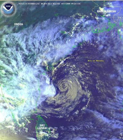
Early this year (late April 2008), a deadly tropical cyclone would form in the Bay of Bengal but would not directly affect Bangladesh. Tropical Cyclone Nargis struck the Myanmar (formerly Burma) coast on 2 May with deadly force. With sustained winds of 208 km/h (130 mph) and gusts reaching 256 km/h (160 mph) — the equivalent of a strong Category 3 or minimal Category 4 hurricane on the Saffir-Simpson scale — Nargis made landfall near Cape Negrais and continued across the Ayeyarwady Delta on its way towards the capital city of Yangon (Rangoon). The initial official death count was 77,738 confirmed dead with 55,917 missing and 19,359 injured. The United Nations estimated that as many as 2 million people were affected by the storm. Full details and an updated death count are yet unavailable due to the reluctance of the Myanmar government to communicate with the outside world. And as I wrote this piece, Cyclone Reshmi struck the Bangladesh coast on 27 October 2008 with initial accounts reporting the loss of ten lives and scores missing. Tragic as the Myanmar storm was (as well as others striking India and Myanmar/Burma), in this piece I focus on the events in the region of the Bay of Bengal north coast known today as Bangladesh. The Geography of BangladeshToday's nation of Bangladesh lies within the traditional region of Bengal, sharing it with the Indian State of West Bengal. Its current borders were set in 1947 with the partition of Bengal from India and became the eastern portion of the new nation of Pakistan. It became independent from Pakistan in 1971. Bangladesh's 150 million-plus inhabitants live on 147,570 square km (55,599 sq mi) ranking it the 11th densest populated nation, though most nations ahead of it in population density are small city-states. Dhaka is the capital and largest city of Bangladesh. Other major cities include Chittagong, Khulna, Rajshahi, and Barisal. 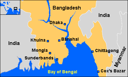 Map of northern Bay of Bengal coastline |
||||||||||||||||||||||||||||||||||||||||||||||||||
| Category | Wind Speeds (10-minute sustained) |
|---|---|
| Depression or Tropical depression | <51 km/hr (<32 mph) |
| Deep depression | 51-61 km/hr (32-38 mph) |
| Cyclonic storm | 62 to 87 km/hr (39-54 mph) |
| Severe cyclonic storm | 88 to 116 km/hr (55-72 mph) |
| Very severe cyclonic storm | 117-220 km/hr (73-137 mph) |
| Super cyclonic storm | >220 km/hr (>137 mph) |
The super cyclonic storm is the equivalent of a Safir-Simpson Category 5 hurricane.
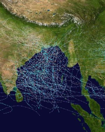
 On average, the North Indian Ocean experiences about 5 tropical storms of which two are cyclone storms (what we call hurricanes in the Atlantic basin). On average, 1.4 cyclonic storms form in the Bay of Bengal annually. A recent climatology of landfalling tropical cyclones for Bangladesh covering a 124-year period (1877-2001) found a total of 133 tropical cyclones hit the coast of Bangladesh. Of these, 42 were tropical depressions, 57 were tropical storms and 34 reached cyclonic storm (hurricane) intensity. The rate of tropical cyclones hitting the Bangladesh coast during the past century (1900-2001) was 1.06 per year. However, for the last 51 years (1950-2001) the rate increased to 1.26 per year. Most (74%) of the cyclonic storms struck during October and May with only a few occurring in January, February and March.
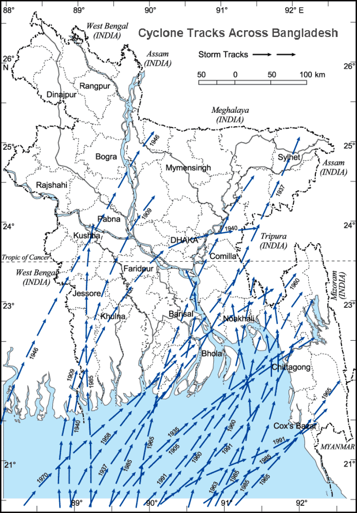
The study found that the landfalls are not evenly distributed along coastal segments. During the 1877-2001 period, 33 percent of the total landfalling cyclones hit the Khulna coast in the southwest of Bangladesh, while the Cox's Bazar coast in the southeast took only 7% of the total landfalls. The remaining struck the central Bangladesh coast.
Cyclones in the Bay of Bengal typically produce sustained wind speeds of 150 km/h (94 mph) and push storm surges which are 3-9 metres (10-30 ft) above the normal astronomical tide. Due to Bangladesh's flat terrain, a severe surge can push inland as far as 200 km (120 miles).
Storm surges are the more dangerous elements of cyclones in Bangladesh, killing many people and livestock and destroying houses and crops as they push inland. The funnel-shaped northern coast of the Bay of Bengal with apex along the Bangladesh coast and the shallow coastal waters accentuates the surge, pushing sea water far up the delta. Effects of the storm surge are greatest when the storm hits at high tide. In 1997, a very severe cyclonic storm hit during low tides, but caused relatively less damage than other similar storms that hit at higher tides.
Traditionally, tropical cyclones in the North Indian Ocean have been identified by a basin location code — BOB for those in the Bay of Bengal and ARB for the Arabian Sea — followed by a four-digit number. The number is made up of the last two digits of the year followed by a two-digit sequential number, starting with 01 each year. For example, the second tropical cyclone of 2004 in the Bay of Bengal will be identified as BOB 0402. It is only in the last few years that cyclones were given names.
Beginning in September 2004, the Panel on Tropical Cyclones for the Bay of Bengal and the Arabian Sea implemented its own popular name list, the last basin to do so. The names are followed by the traditional identifier, e.g., Angi ARB 0404. The lists of popular names for use for the period from mid-2004 until 2009 was produced by the India Meteorological Department from suggestions from Bangladesh, India, the Maldives, Myanmar, Oman, Pakistan, Thailand and Sri Lanka. The names are ordered by the English alphabetical order of country names. The lists, which began with Onil in 2004, will be used sequentially and will only be used once. The first name for a given year is the one immediately following the last name used in the previous year. (I assume a whole new list will be produced for the years following 2009.)
| List of North Indian Ocean Cyclone Names from 2004-2009 | ||||||
|---|---|---|---|---|---|---|
| Contributed by | List I | List II | List III | List IV | ||
| Bangladesh India Maldives Myanmar Oman Pakistan Sri Lanka Thailand | Onil Agni Hibaru Pyarr Baaz Fanoos Mala Mukda |
Ogni Akash Gonu Yemyin Sidr Nargis Abe Khai-Muk |
Nisha Bijli Aila Phyan Ward Laila Bandu Phet |
Giri Jal Keila Thane Mujan Nilam Mahasen Phailin | ||
| Contributed by | List V | List VI | List VII | List VIII | ||
| Bangladesh India Maldives Myanmar Oman Pakistan Sri Lanka Thailand | Helen Lehar Madi Na-nauk Hudhud Nilofar Priya Komen |
Chapala Megh Vaali Kyant Nada Vardah Sama Mora |
Ockhi Sagar Baazu Daye Luban Titli Das Phethai |
Fani Vayu Hikaa Kyarr Maha Bulbul Soba Amphan | ||
 |
To Purchase Notecard, |
Now Available! Order Today! | |
 |
 |
Now |
The BC Weather Book: |


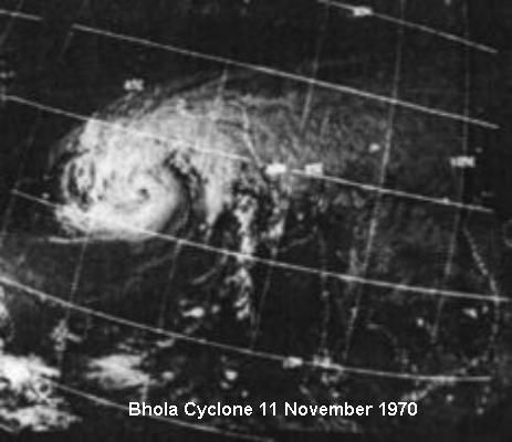 In November 1970, famed Indian sitarist Ravi Shankar became distressed over the human misery following a severe tropical cyclone that struck the Chittagong Coast and Ganges Delta region of East Pakistan. The storm took an estimated 300,000 lives, the greatest weather disaster of the 20th Century. Following the natural tragedy, millions more were affected as civil war broke out across the region when East Pakistan broke away from West Pakistan, eventually forming the new nation of Bangladesh.
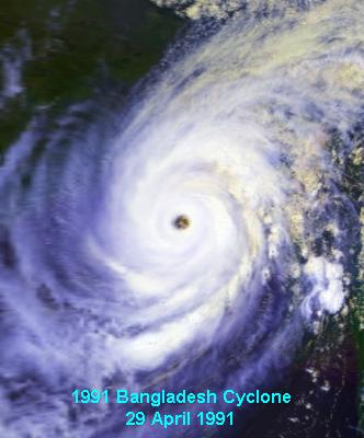 Tropical storm warnings for the region were still in their infancy at the time of the 1991 storm, and the consulting company I worked for proposed the development of a storm-warning system, a project I dubbed BEWARES for Bay of Bengal Early Warning System. While the initial proposal circulated around international agencies, I left the company but have kept the region in the corner of my weather eye.
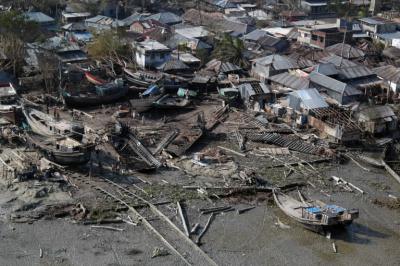
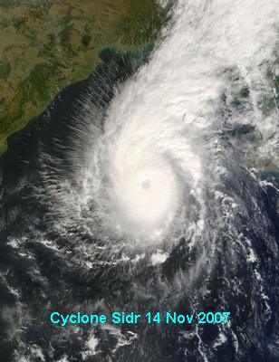 The last major storm to directly hit the Bangladesh coast did so on 15 November 2007. Tropical Storm Sidr, designated 06B and also known as Super Cyclonic Storm Sidr, boasted peak sustained winds of 260 km/h (160 mp/h), a Category-5 equivalent tropical cyclone on the