| Home | Welcome | What's New | Site Map | Glossary | Weather Doctor Amazon Store | Book Store | Accolades | Email Us |
 | |||||||||||||||||||||||
Weather Almanac for April 2008DEADLY TORNADOES OF APRIL 1908
That so many tornadoes struck the United States during the opening months of 2008 with a death toll totalled less than 100 lives is perhaps a testament to the efficacy of the American tornado warning system and the diligence of storm watchers. As far as I can determine, the greatest number of fatalities from a single tornado this year has been 24 in Macon County, Tennessee on 5 February 2008. The outbreak sent me to the record books to see where on the list of the deadliest individual tornadoes in American history struck. What struck me first was that despite the increase in US population overall and particularly in many tornado-prone areas, the most recent Top-25-deadliest tornado on the list occurred on 25 May 1955 in Udall, Kansas, more than half a century ago (80 dead). Further perusal of the list revealed that two of the deadliest (in the top 20 storms) occurred on the same day a century ago: 24 April 1908. The seventh deadliest individual tornado struck from Amite, Louisiana to Purvis, Mississippi, leaving 143 dead. That same day in the Natchez, Mississippi area, a tornado took 91 lives. Interestingly, Natchez is the only community that appears twice on the Top 25 list, holding the number 2 spot as well as the 19th. The deadlier Natchez tornado, which scored a direct hit on the town, took 317 lives in May 1840, a storm I chronicled in a previous article. Note: All tornado ratings are on the old Fujita (F) Scale and taken from Significant Tornadoes 1680-1991 by Thomas P. Grazulis, 1993. Many of these storms had long paths and are considered by Grazulis to be families, that is, a number of tornadoes formed from a single supercell in such close proximity that it is difficult to distinguish between the members of the family in time or space. Such events are thus often considered as a single tornado. The Outbreak of 23-25 April 1908The weather chronicles note at least 34 tornadoes struck the southern United States during the period 23-25 April 1908. Tornadoes were reported in the southern states from Texas to Georgia and from Oklahoma to Tennessee as well as in the upper Midwest. Sixteen killer storms took a total of 324 lives and injured 1,652 others, mostly in Louisiana, Mississippi and Alabama. Six of the tornadoes were later classified by Tom Grazulis as violent: F4 or F5 intensity.
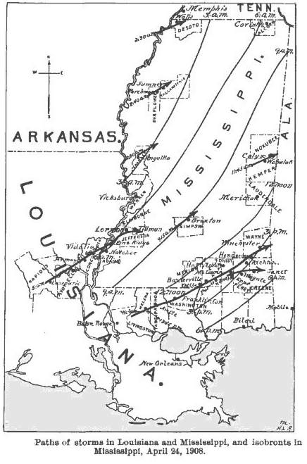
The first tornadoes to strike the region hit Texas and Arkansas on the 23rd. (Tornadoes were also reported that day in South Dakota, Minnesota, Nebraska and Iowa. Three died in the Nebraska F5 twister.) Six significant tornadoes (F2 class or higher) crossed Texas with four fatalities. The worst tornado in Texas, classed F4, devastated the eastside of the town of Deport. The deadliest day in this stormy period occurred on 24 April. On that date, Thirteen significant tornadoes hit Mississippi, Louisiana, Alabama and Tennessee beginning at 2:30 am, local time and not ending until 11 pm. The two deadliest tornadoes stuck Louisiana and Mississippi. The first began around 5 am in Louisiana before crossing the river into Natchez, Mississippi. The second, known as the Amite or the Amite/Purvis storm touched down just before noon and was the big killer of the outbreak.
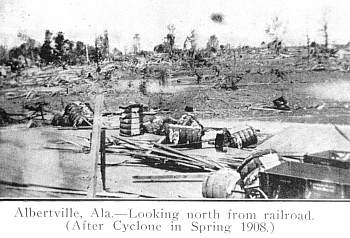
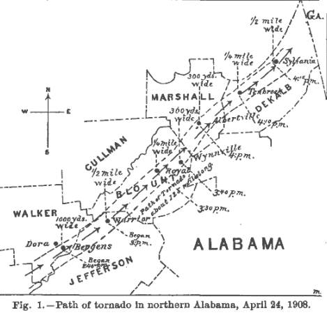
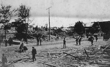
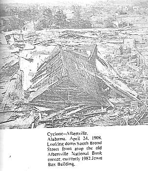
The third most deadly twister moved across Alabama at around 2:30 pm. According to the Monthly Weather Review report by Frank P. Chaffee, Section Director, Montgomery, Alabama, it began its 105-mile (168 km) path "near Dora, Walker County, about 2:40 pm, past over Warrior, Jefferson County, at 3 pm, was next felt at Royal, Blount County, 3:30 pm, at Wynnville, Blount County, 3:40 pm, at Albertville, Marshall County, 4 pm, at Tenbroek, DeKalb County, 4:l0 pm, and seems to have ended a few miles northeast of Sylvania, DeKalb County, about 4:15 pm."
He reported: "A funnel-shaped cloud swept along the entire path of the storm. The cloud is reported to have had a bounding and whirling motion, and to have swept everything from its path where it touched the ground. A loud, rumbling noise was heard from the cloud, which emitted brilliant lightning. A noteworthy fact is that the rainfall, while heavy during the passage of the storm, was not nearly so heavy near the track as it was at points 50 to 100 miles [80-160 km] to the southward, where it was generally excessive. Heavy and damaging hail also fell at points to the south of the storm's path." As it raced through Bergens, Alabama, the twister destroyed most of the town, and twelve died. Fifteen more fatalities occurred near Albertville in Marshall County where half the town was leveled. Local observers reported the tornado picked up a nine-ton oil tank at Albertville and carried it for half a mile (800 m). The tornadic winds ripped a nine-car freight train at Albertville from the tracks and overturned it, destroying all its cars. The funnel finally dissipated north of Sylvania in DeKalb County after 105 miles (168 km). In total 35 died and 188 injured from the storm's fury. The F4 tornado destroyed 237 buildings and caused more than $500,000 ($11,622,000 in 2007 dollars) in damages in total.
A fourth F4 tornado hit in the evening, touching down in Cherokee, Alabama before moving into Georgia. In Blufton, Alabama, almost every building had storm damage, and one man died. Three died near Hematie, Georgia and another seven near Cave Spring, Georgia. The number injured was reported to be fifty. Killer tornadoes also struck Epps, Mississippi (five dead), Wahalak, Mississippi (two dead), Fort Deposit, Alabama (two dead) and in Bradley County, Tennessee (one dead). In addition to the five deaths (possibly seven) in Epps in Perry County, twenty were injured, most when the tornado struck a turpentine mill. By the 25th, most of the tornadic activity moved into Georgia where seven significant tornadoes struck, leaving 20 dead and 161 injured. The strongest storm, an F3, hit Harris and Meriwether counties. Nine of the ten deaths happened in Chipley (now Pine Mountain) where forty homes, four churches and a hotel were destroyed. The Natchez Tornado
The first of the two infamous tornados to strike that day began its 105-mile (168 km) trek across Louisiana and Mississippi at about 5 am, touching down a mile north of Lamourie, Louisiana. The storm's first fatalities occurred when three members of a family at Richland died. Four more succumbed at Ruby as the tornado raked plantations in east central Louisiana. At least 39 died in Louisiana before the funnel crossed the Mississippi River north of Vidalia at Giles Bend. Passing north of the Natchez core, it took 30 lives and injured 200 others on the plantations near Pine Ridge, Mississippi. Several antebellum mansions were "literally dismantled" by the violent winds. Twenty-one more died in the Church Hill area near Lorman, Jefferson County and 82 injured, many of the deaths occurred when the "cyclone" demolished the frail homes of tenant farmers. The line for this F4 tornado lists 91 dead and 700 injured in its wake. The Amite–Purvis TornadoLike the Natchez Tornado, the Amite–Purvis tornado first touched down in southeastern Louisiana before crossing into Mississippi. The initial funnel touchdown came near Weiss in northwest Livingston Parish at 11:45 am. As the storm moved northeastward, it took two lives at Dennis Springs and another two near Montpelier. The greatest destruction in Louisiana came at Amite where locals reported the funnel to be over two-miles (3.2 km) wide. The report of the tornadoes striking Louisiana on 24 April 1908 published in the Monthly Weather Review was written by the District forecaster, Isaac M. Cline. (Weather history buffs should recognize this name. Cline was the forecaster in Galveston, Texas eight years earlier when the deadly hurricane struck that Texas coastal community. Cline is the lead figure in Eric Larson's book Isaac's Storm.) Of this storm, Cline wrote: "This first tornado made its appearance in the vicinity of Lamourie, Rapides Parish, about 5 a. m. It came from the southwest and traveled toward the northeast across Avoyelles, Catahoula, and Concordia parishes, a distance of about 70 miles,[112 km] and past into Mississippi at Giles Bend near Vidalia. The majority of reports state that there was a well-defined pendant funnel-shaped cloud, and rotary winds of sufficient violence to uproot trees and destroy buildings. The path of greatest destruction ranged from 300 to 700 yards [92-640 m] in width." "The second tornado made its appearance between 11 a.m. and 12 noon in the vicinity of Weiss, Livingston Parish. The storm came from the southwest and moved toward the north-east across St.Helena, Tanngipahoa, and Washington parishes, and past into Mississippi near Balltown, La. There was a well-defined pendant funnel-shaped cloud, with rotary winds of sufficient violence to uproot trees and prostrate buildings in its path. The path of greatest destruction ranged in width from one-half mile at Weiss to two and one-half miles at Amite, and covered a distance of about 80 miles in Louisiana." A number of Louisiana towns were destroyed in part or in whole including: Amite, Arcadia and Independence At least 29 died in Amite and 60 injured; four others died south of Wilmer. Before the storm left Louisiana, it injured eleven in the Aurora-Franklinton area of Washington Parish, and killed nine people near Pine. Cline placed the toll from the Louisiana portion of this tornado at 46 dead, 116 injured and property losses around $275,000 (6,392,270 in 2007 dollars).
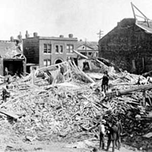
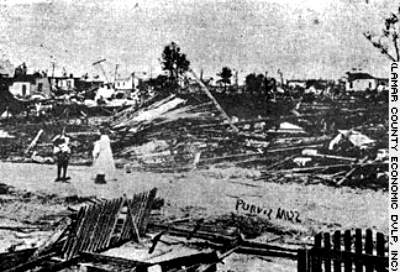
Continuing its path of devastation across the state line near Balltown, Mississippi. The twister took two lives in Marion County before taking aim on Purvis in central Lamar County. Only seven of the 150 homes in the town remained standing after the storm passed through, the remainder of Purvis was leveled. Fifty five died and over 400 injured. Losses in Purvis were set at $500,000 ($11,622,000 in 2007 dollars). As the tornado continued its deadly journey northeastward, it stuck a train 8 miles (12.8 km) south of Hattiesburg, killing four members of a railroad work crew who sought refuge in a box car. The tornado threw the box cars 150 feet (46 m), tearing them apart. Seven more died when the storm moved southwest of Richton. W.S. Belden, Section Director of the Weather Bureau in Vicksburg, Mississippi estimated 155 dead, 970 injured and over a million dollars in damage in his Monthly Weather Review report dated 27 May 1908.
The final total for this F4 tornado stands at 143 dead and 770 injured. Its estimated 155-mile (248 km) path ranks fourth longest path for a tornado on record. Learn More From These Relevant Books
|
|||||||||||||||||||||||
 |
To Purchase Notecard, |
Now Available! Order Today! | |
 |
 |
Now |
The BC Weather Book: |


 The outbreak of deadly tornadoes that hit the American South during the first third of 2008 sent many scurrying to the record books to find similar or worse events. The Super Tuesday (5–6 February 2008) outbreak took 58 lives, the most deaths from a tornado outbreak since the 31 May 1985 outbreak that killed 76 across Ohio and Pennsylvania. As of the end of March 2008, tornadoes in the United States have taken over 70 lives. The number of confirmed tornadoes at that time stood at nearly 270 with another two hundred reported but as yet unconfirmed.