NOCTILUCENT CLOUDS: MYSTERY IN THE HIGH ATMOSPHERE
About two years after the catastrophic eruption of Krakatoa in 1885, sky watchers in Europe began seeing splendid displays of clouds in the evening sky that apparently had not been seen before. These wispy filaments of electric blue and white cloud were unique because they only became visible when the sun was well below the horizon. First described in the open literature by German Thomas W. Backhouse, they were given the name noctilucent cloud, meaning "night shining." The term noctilucent clouds (Leuchtende Nachtwolken) likely originated with O. Jesse of the Berlin Observatory. However, records indicate that Thomas Romney Robinson, Director of the Armagh Observatory in Northern Ireland, may have been the first to document these clouds, at least 35 years earlier than Backhouse. On 1 May 1850, he noted in his observational diary: "strange luminous clouds in NW, not auroral."
Observations of these special clouds after Backhouse's discovery suggested they were only visible north of about 50 degrees latitude. Scientists first speculated that the dust particles from Krakatoa, that circled the Earth at a height of about 80 km (50 miles), caused noctilucent clouds. But when the dust of Krakatoa finally settled, observers continued to see noctilucent clouds at high latitudes during the summer.
Over the past century, noctilucent clouds have been considered as infrequent residents of the sky. But in the past decade or so, sightings have become more frequent, and the clouds have even been seen at much lower latitudes. Have they truly become more common? Or are they, like many other natural phenomena, noticed more because more eyes are looking? Robinson's observations suggest that the clouds were there and seen well before Krakatoa, but that the attention played to the sunset/sunrise skies following the eruption resulted in regular sightings of noctilucent clouds.
One website that has featured sightings and discussions of noctilucent clouds is Space Weather (http://www.spaceweather.com/) compiled by Dr Tony Phillips of NASA. The site, which I first visited when working on my piece on the aurora and space weather, has featured observations of noctilucent clouds for some time and maintains a Noctilucent Cloud Gallery 2007 of photos submitted by readers. The full gallery has photos dating back to 2003, and provides a good primer in what to look for if you decide to seek the illusive noctilucent.
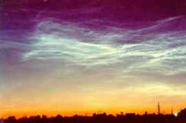
I See Them
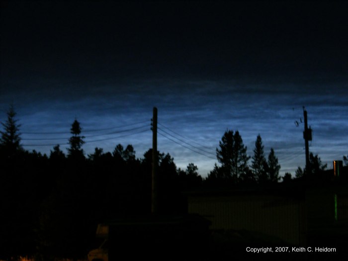
As I now live above 50 degrees N (52o 46' N, 119o 15' W), I began watching the evening sky for noctilucent clouds (also known by the acronym NLCs) this summer. I became more vigilant when photos of them were submitted to Space Weather by folks in northern Washington and elsewhere in British Columbia in early July. Unfortunately, at the time, we were plagued with evening cloudy skies, and the nearby mountains reduce my horizon-line view.
However, on the evening of 6 July 2007, I witnessed a display of noctilucent clouds for the first time. I noticed the clouds beginning at 10:59 pm (PDT) and they were still visible after 11:21 pm, but falling below the horizon. (Local sunset was at 9:22 pm.) I ran to get my digital camera and snapped a series of photographs (collected here). To make sure I did not miss the display, I did not take the time to search for my tripod, so the first series are a bit shaky as the exposure time required is long. After documenting the display, I located my tripod and used it to snap the last two photos.
I have looked each night for a return display, but so far, no luck, though we have again been in a very rainy period and the prime season for viewing them is nearing its end. Indeed, the night I saw them I was also treated to a good thunderstorm and at first did not expect the lower skies to clear enough to see any noctilucent. When I did look out just before 11 pm, I was surprised that the skies had cleared sufficiently to see the display.
My NLCs were more a veil pattern than some of the wispy filament observations seen over Europe this summer. They also were whiter looking, at least on the photograph than the striking electric blue of other photos. My camera was set with a three-second exposure time, a night setting available on my Fujifilm FinePix S700.
Noctilucent Clouds
Much about noctilucent clouds remains a mystery. What is known is that they form in the high atmosphere between about 75 and 85 km (47-53 miles). They are thought to be small ice-coated particles, though some favour dust for their composition. They are extremely tenuous, so transparent that they only reflect 1/1000 of the incident solar light they receive, and thus NLCs are only visible when illuminated from below against a dark background.
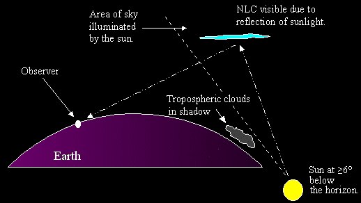
Their height, in the upper stratosphere to lower mesosphere but well above the troposphere where most weather occurs, allows them to catch the sunlight when the sun is well below the horizon, usually 6 to 16 degrees, generally about 30 minutes after sunset. For this reason they are usually seen in the western sky. The clouds themselves typically range from 15-20 degrees above the horizon, along the edge of the twilight arch.
There doesn't seem to be many reports from before sunrise (in the information I have seen) but I would think they should appear in the eastern sky before sunrise as well unless they form only after some solar heating of the upper atmosphere. A few recent scientific studies using short observational periods suggest nearly equal distribution in time of occurrence before and after local midnight. Perhaps the aberration of more evening sightings is just a reflection of summer sleep habits of the observers; dawn at these high latitudes comes very early.
The annual peak of NLC observations occurs a few weeks either side of the summer solstice with Northern Hemisphere observations ranging from mid-May to mid-August, just about the range of solar summer (most solar light and longest days). The most likely region for viewing is between 50 and 65 degrees latitude. Further north, we are in the realm of the midnight sun or at least strong midnight twilight which makes the sky too bright. South of there, twilight is not long enough as the sun dips below the horizon into night conditions more quickly. That does not mean that they cannot be seen further south as observations this year in Utah and Colorado attest. In the Southern Hemisphere, ground-based observations are infrequent due to the fact that hemisphere has little land area within the favoured band.
The optimum viewing geometry for noctilucent clouds. Sunlight scattered by tiny ice crystals in NLCs is what gives the clouds their characteristic blue color. Courtesy NASA
An early observer of NLCs, Robert Leslie described them as "...weird small cloud forms, at times very regular, like ripple marks in sand, or the bones of some great fish or saurian embedded on a slab of stone." Observations over the years confirm Leslie's description and tell us NLCs can appear as complex streaks or thick veils with a white, electric blue, or pearly blue hue. They may have a fishnet appearance or exhibit bands, waves or whirls. NLCs often look like daylight cirrus but experienced observers tell us they show finer details under binocular or other magnification whereas cirrus tend to be nebulous when so viewed.
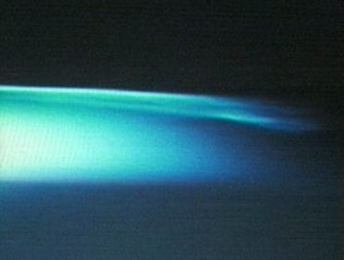
Electric blue noctilucent clouds viewed from the ISS. Photo credit: Don Pettit and NASA TV.
NLCs have also been viewed from space by the astronauts in the International Space Station. Astronaut Don Pettit viewed a display over the Southern Hemisphere in early 2003 (late January to early February). "We routinely see them when we're flying over Australia and the tip of South America," he said. While a staff scientist at the Los Alamos National Laboratory between 1984 and 1996, Pettit had studied NLCs that were seeded by high-flying sounding rockets. "Seeing these kinds of clouds [from space] ... is certainly a joy for us on the ISS," he said on NASA TV.
A good overview of NLCs and identification manual Observing Noctilucent Clouds by M Gadsden and P Parviainen can be downloaded in pdf format from the International Association of Geomagnetism and Aeronomy. To download the file, click here.
Their Cause
At present, there are two main theories as to the cause and formation of NLCs. The dust theory proposes that the clouds form from either volcanic or cosmic (meteorite) dust. One of the arguments for this theory cites the first observations after Krakatoa as evidence and supplement that with the fact that most observations fall around the time of summer meteor showers. There are several important flaws in this theory and it is generally rejected, though high-altitude dust may provide the seeds for ice crystals.
The main theory holds that the NLCs are composed of water ice nucleated by small dust particles or ions in the mesopause region. Since this region is very dry ("one hundred million times drier than air over the Sahara desert"), the temperatures must be very low to produce supersaturation of the local air. How ice crystals form in the arid air is the essential mystery of noctilucent clouds.
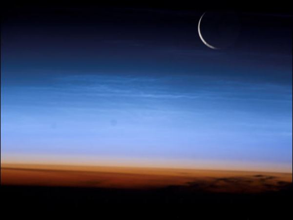
The sliver of the setting moon and noctilucent clouds caught the eye of astronaut Ed Lu aboard the International Space Station (ISS) on 27 July 2003 when the ISS was over central Asia. Courtesy NASA
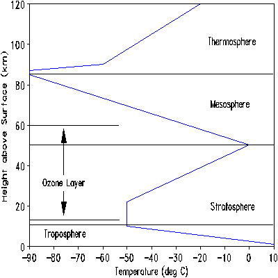
Intuitively, one would think it gets colder as one ascends higher into the atmosphere, based on our observations of the lower atmosphere. But this is not the case. The continual drop in temperature stops as we pass through the tropopause into the stratosphere. After an isothermal layer, the stratosphere begins warming in its upper regions due to the absorption of solar ultraviolet (UV) radiation by ozone in the ozone layer. The hottest region of the atmosphere above the troposphere's surface layer is actually found around the stratosphere-mesosphere boundary. (The thermosphere, where atmosphere and outer space become indistinguishable is technically hotter still.)
So how does this region cool down sufficiently for NLCs to form? The answer may be found in gravity waves, the term used by upper-air meteorologists (aeronomers) to describe buoyancy waves generated by differences in air density (a wave on the ocean is also a gravity wave). These waves can be caused by the jet stream, towering thunderstorm clouds, or mountain ranges. The waves force air upward, but in doing so, the air cools which dampens the wave. The full mechanism is a complex interaction between solar radiation, local chemistry of the ozone layer and fluid dynamics forces. I'll leave out most of the details on the process here (see http://www.atm.helsinki.fi/~tpnousia/nlcgal/nlcinfo.html for more).
Atmospheric Layers Mesopause is at the boundary of the mesosphere and thermosphere
The motion of the wave through the mesosphere results in an extreme cooling of the local temperature field by as much as 60 K (60 C degrees) over the non-sun winter values, down to around 130 K (-143oC / -225oF). Interestingly, this process only can happen during the summer months in the mesosphere, and only some properly oriented gravity waves can produce such changes.
These gravity waves may also provide the water vapour needed to form the clouds by moving it upward from the stratosphere. The waves also provide the brush by which NLCs derive their characteristic textures and shapes. Water vapour can also be injected through the breakup of methane gas molecules by solar energy at these high altitudes. The chemical process involves ozone and free oxygen also present at these altitudes. But water is not immune to the energetic solar beam and is also broken up. Estimates give a water molecule an average lifetime of 3-10 days in the mesopause region (the boundary between the upper stratosphere and lower mesosphere).
Satellite observations show that NLCs are also present poleward of 60 degrees, but the "midnight sun" of summer obscures their sighting from the ground. Often the whole polar region is covered with these high clouds which are referred to in this context as polar mesospheric clouds.
Based on surface observations, the particles making up NLCs are likely very small, less than 50 nanometres (one nanometre is one-billionth of a metre and 2.5x10⁻⁷ of an inch). To understand more about NLCs, researchers at NASA and Hampton University in Virginia have undertaken the AIM Mission.
Finally, some scientists believe there is a connection between the increase in NLC sightings and climate change. They suggest that the increase in greenhouse gases has raised the temperature in the lower atmosphere but has lowered the temperature in the upper atmosphere. A reduction in the ozone layer could also change the nature of the region resulting in lower temperatures. The atmospheric content of methane has also been rapidly increasing over the past centuries, and some of this may be reaching the upper atmosphere where it can be photo-dissociated and increase the water content.
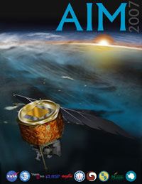
The AIM Mission
The extreme altitude and limited extent of NLCs makes the probing of these clouds from the Earth's surface difficult at best. In order to determine the nature of NLCs, NASA in conjunction with Virginia's Hampton University and other research groups launched the Aeronomy of Ice in the Mesosphere (AIM) mission to provide the first detailed exploration of these unique and elusive clouds sitting literally on the "edge of space." The launch of the AIM satellite came on 25 April 2007 aboard a Pegasus XL Rocket from Vandenberg Air Force Base in California.
AIM Mission Poster
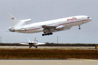
Takeoff of the L-1011 carrier aircraft, Stargazer, with the Pegasus XL rocket and NASA's AIM spacecraft. Image credit: NASA
Over the two-year mission, AIM will document for the first time the entire complex life cycle of polar mesospheric clouds(aka noctilucent clouds). AIM will take wide angle photos of NLCs to see their structure. The satellite instruments will also measure their temperatures and chemical abundances, monitor dusty aerosols, and count the meteoroids raining down on Earth. With this data, scientists hope to unravel many of the mysteries about what NLCs are and how they form.
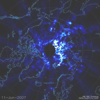
On 11 June 2007 AIM's satellite cameras sent its first visual data documenting noctilucent clouds over the Arctic regions of Europe and North America.
White and light blue represent noctilucent cloud structures. Black indicates areas where no data is available.
Credit: Cloud Imaging and Particle Size Experiment, University of Colorado Laboratory for Atmospheric and Space Physics
Once the summer season ends in the Northern Hemisphere � mid- to late August � the satellite's attention will turn to the Southern Hemisphere in late November. Following southern summer, the focus will again return to the north. The project team has planned for two complete seasons of measurement in both hemispheres.
Keep track of the AIM Mission news at their websites: NASA (http://www.nasa.gov/mission_pages/aim/index.html)
AIM Project Data Center, Hampton University ( http://aim.hamptonu.edu/index.html).
The AIM folks even have a mission song Noctilucent Cloud written by Patricia Boyd and sung by The Chromatics. You can hear the song from their AstroCappella CD here.
Learn More About Weather From These Relevant Books Chosen by The Weather Doctor
For More Weather Doctor articles, go to our Site Map.
I have recently added many of my lifetime collection of photographs and art works to an on-line shop where you can purchase notecards, posters, and greeting cards, etc. of my best images.


 About two years after the catastrophic eruption of Krakatoa in 1885, sky watchers in Europe began seeing splendid displays of clouds in the evening sky that apparently had not been seen before. These wispy filaments of electric blue and white cloud were unique because they only became visible when the sun was well below the horizon. First described in the open literature by German Thomas W. Backhouse, they were given the name noctilucent cloud, meaning "night shining." The term noctilucent clouds (Leuchtende Nachtwolken) likely originated with O. Jesse of the Berlin Observatory. However, records indicate that Thomas Romney Robinson, Director of the Armagh Observatory in Northern Ireland, may have been the first to document these clouds, at least 35 years earlier than Backhouse. On 1 May 1850, he noted in his observational diary: "strange luminous clouds in NW, not auroral."