| Home | Welcome | What's New | Site Map | Glossary | Weather Doctor Amazon Store | Book Store | Accolades | Email Us |
 | |||||||||||||||||||
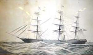
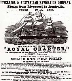
Weather Almanac for October 2006THE ROYAL CHARTER STORMStorms throughout history have often played a major social role — Hurricane Katrina, for example — and several have influenced the discipline of meteorology — such as the storm system that prevented Ben Franklin from watching the lunar eclipse. One such storm struck the British Isles in late October of 1859 and is considered as among the worst storms to occur in the Irish Sea during the century. The story of that storm and its impact are chronicled here. The storm's fury, and the impacts of several other storms in the succeeding weeks, left a legacy that gave birth to one of the most important functions of applied meteorology: the weather forecast. In the extended fortnight beginning 25 October and ending 9 November, storms around the British coast caused 325 shipwrecks with the loss of 748 lives. An enquiry held to assess the causes of the disastrous loss of shipping and lives during this period proposed a novel solution. The British Association doing the inquest recommended that the Meteorological Department of the Board of Trade headed by Robert FitzRoy use the new electric telegraph to warn coastal communities of storms in offshore waters. This ultimately led to the first official gale warnings in February 1861, and soon afterward to regular weather forecasts, a term coined by FitzRoy. Does the name FitzRoy ring a bell? Yes, this is the same man who captained HMS Beagle on its famous voyage with a young Charles Darwin on board as naturalist. The story of FitzRoy and weather is an important one which I will address in November. The Royal CharterThe infamous storm derives its name, The Royal Charter Storm, from that of the prime ship lost during its passage over the British Isles. The Royal Charter was an iron steam-driven clipper launched in 1857 and registered at 2719 tons. Owned by the Liverpool & Australian Navigation Company, The Royal Charter was built at the Sandycroft Ironworks on the River Dee. She boasted an impressive three tall masts and 200-hp engine. She had room for up to 600 passengers, with luxury first-class accommodations. Her figurehead was a winged messenger, an appropriate choice as she was designed for fast sailing on the Britain–Australia run. With steam engines to maintain speed when winds were light, The Royal Charter could complete the trip between Melbourne, Australia and Liverpool, England in about 60 days, nearly a month better than her competitors.
The Royal Charter left Melbourne, Australia on 26 August 1859 under the captaincy of Captain Thomas Taylor who had made the voyage from Liverpool to Melbourne in a record 59 days. For this run she had with her a full complement of officers and crew, 112. She was a "gold ship" carrying an estimated Ł150,000 in gold sovereigns and an additional Ł322,440 of gold bullion in her strong room. Some of her 371 passengers were returning from the Australian gold fields with their fortunes.
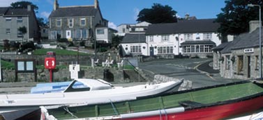
The Royal Charter sailed quickly across the Indian Ocean and safely negotiating the Cape of Good Hope, though around the Cape, the vessel closely approached an iceberg. Headed northward she had crossed almost the entire length of the Atlantic Ocean when she approached the British Isles. As the ship lay at anchor about 20 miles (32 km) off the Cove of Cork on the Irish Coast, not a breath of wind to disturb the waters on 24 October. At a testimonial that evening, Captain Taylor boasted to those in first-class accommodations that they would reach Liverpool by the following evening. But the next morning, as The Royal Charter approached the northwest Wales coast, Captain Taylor observed the barometer was falling and informed the crew that he saw stormy weather approaching over the Snowdonia Mountains. Later, some passengers would claim that Taylor was advised to seek shelter in Holyhead Harbour on the Anglesey west coast, but that he decided instead to run for Liverpool in order to keep the ship's speedy reputation untarnished. The StormThe weather in the northeast Atlantic and surrounding seas had been unsettled for several days as October entered its fourth week. As noted by those aboard The Royal Charter, the winds in St George's Channel were becalmed the evening of the 24th, but Taylor noted a falling barometer and signs of stormy weather ahead the following morning. Around 3 PM on the 25th, the wind on the English Channel suddenly shifted and increased in speed. The approaching storm would do structural damage along the coasts of Devon and Cornwall. On the Pembrokshire coast, storm winds and surge swept most of the ancient St Brynach church at Cwm-yr-Eglwys into the sea, leaving only the western end wall and bellcote. On the northern Wales coast, east of Anglesey, the wind rose the morning of the 25th to a northeasterly gale. The winds drove huge waves into Llandudno Bay which a local observer described to be "like mountains roaring into the bay and smashing on the site of the present promenade." Experienced mariners and long-time residents remarked that the such mountainous breakers had never before been seen there. 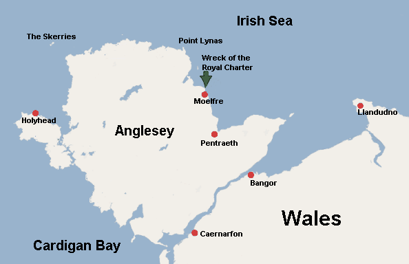 The Isle of Anglesey and Surrounding RegionThe foaming sea and driving sea spray whipped by hurricane-force winds overwhelmed a row of thatched cottages, driving their residents inland. A kitchen table, its legs pointing skyward, was observed being drawn out to sea. The incessant sea battered Llandudno's new pier, constructed recently to challenge Holyhead for the prime "Irish Port" for British shipping headed to the Emerald Isle. Most of the pier's large timbers were swept away and then battered into matchsticks. The remains were widely strewn over the beach. As the storm center pushed northward, the winds picked up in the Irish Sea later in the evening, hitting Anglesey by about 8 PM. The storm reached maximum strength at the River Mersey around midday of the 26th. Winds reached Force 12 on the Beaufort scale, peaking at well over 80 mph. A wind force measurement at Mersey registered 28 lbs to the square foot, the highest recorded to date. Around Wales, the storm's impact was noted in reports from other communities. At Caernarfon, "the effect of the storm was awful along the whole coastline here." The Bangor account noted: "On Tuesday afternoon Bangor and the surrounding coastline was visited by one of the most awful storms ever seen here. The vessels along the coast from Pwynt y Garth to Hirael were ripped from their anchors and thrown against the rocks with considerable force, and many of them were severly damaged. But the effect of the storm on the eastern side of Port Penrhyn was truly frightening." At New Quay along the southwest coast of Wales, the news was equally grim: "The storm wrought more damage on lives and goods belonging to this town, both here and elsewhere, than any previous storm in history. The wind on Tuesday night was so strong that it was dangerous to venture outside. Things were even worse amongst the ships, most of which were totally out of control, having broken their chains and become mixed up in a chaotic mess. The Lighthouse and a large section of the sea-wall had been washed away by the power of the sea." The storm to be later known as The Royal Charter Storm continued to move northward, crossing Scotland before moving into the North Sea. By then, a trail of destruction and death lay in its wake. At least 200 vessels were lost and over 800 lives both on land and at sea. Of the dead, more than 450 began their day aboard The Royal Charter. The ShipwreckAs The Royal Charter reached the north coast of Anglesey on the northwest Wales coast, the winds shifted to northerly and increased. Less than an hour after passing the Skerries, the facing winds had reached Beaufort Force 10 and an ebbing tide pushed the ship toward shore.
Captain Taylor had called for a pilot off the Skerries but no pilot boat would dare to venture among the violent breakers that dark and stormy night. A similar response came from the Point Lynas pilot when he displayed a blue distress light. But neither Pilot Boat 4 nor Pilot Boat 11 could make it through the storm. By 11 PM, the weather worsened and as The Royal Charter became unmanageable, Taylor decided to drop anchor four miles (6.4 km) off the Anglesey shoreline. At 11:30 PM the port anchor was released, and one hundred fathoms of chain cable paid out. Shortly thereafter, the starboard anchor and seventy fathoms of chain was released. Taylor also squared the sails and shut down the engines in an attempt to ride out the storm without being shoved ashore. Unfortunately, the chosen anchorage exposed the ship to the full brunt of winds and surge coming down from the Irish Sea. Although the anchors held the drift of the ship for a time, the force of the storm and sea was too great and around 1:30 AM, the port anchor cable parted and an hour afterward, the starboard chain followed suite. To stem the drift, Taylor ordered the masts cut to reduce the wind drag. But despite the unsuccessful efforts of the steam engines to make headway against the storm, The Royal Charter was eventually driven toward the rocks of Moelfre Bay. Initially, she grounded on a sandbank but was pushed free only to be dashed against the rocks off the village of Moelfre. Around 3:30 AM, the mammoth seas and hurricane winds slammed the ship against the rocks 50 yards offshore. The Royal Charter broke it in two, and many of those aboard were tossed into the sea. Most died when they were dashed against the rocks in the hissing, pounding sea. Others drowned, weighed down by pockets and belts filled with gold that they wore around their waists.
Guze Ruggier (anglicised as Joe Rogers or Joe Rodgers) a Maltese sailor, dove overboard to pull a hawser line from the ship to the shore. After three fruitless attempts, he finally managed to fasten the rope to a rock. With the help of 28 local men who had rushed down to the shore, he helped form a human chain to rescue some of those in the waters and clinging to the wreckage. Only a few aboard who dared the bosun's chair were rescued. None of the women or children aboard nor any of the ship's officers survived. Despite all rescue efforts, only 41 aboard survived. AftermathFor weeks following the disaster, bodies continued to wash up along the beaches around Moelfie. They were recovered and carried up the hill from the village to a temporary mortuary at St Gallgo's Church. The townsfolk removed the furnishing to make room for the bodies and for weeks held services in the church school, later the site of the inquest hearings. "Forty-four shipwrecked men and women lay here at one time, awaiting burial," according to Charles Dickens.
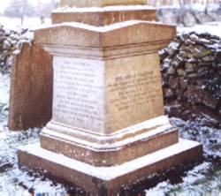
In memory, a plaque was placed on the cliff top above the rocks and beach where the wreck occurred. It reads in part "where The Royal Charter met its end, and the memory of those who died." One hundred forty of the recovered bodies were buried in the nearby Llanallgo churchyard, where the graves and a memorial can still be seen. Sixty four are buried in Llaneugrad, 45 in Penrhosllugwy; while others rest in the parish graveyards near the beaches where they washed ashore. Ironically, Isaac Griffiths, a sailor aboard The Royal Charter, hailed from Moelfre and died within half a mile of his birthplace. Joseph Rogers was later honoured by the Royal National Life Boat Institution and the Board of Trade as "Rodgers of the Royal Charter" for his heroism in saving the 40. Sometime later, Charles Dickens visited the area and spoke with Llanallgo Rector, the Reverend Stephen Roose Hughes. Dickens included the story of the disaster's aftermath in his book The Uncommercial Traveller as Chapter II. "O reader, haply turning this page by the fireside at Home, and hearing the night wind rumble in the chimney, that slight obstruction was the uppermost fragment of the Wreck of the Royal Charter, Australian trader and passenger ship, Homeward bound, that struck here on the terrible morning of the twenty-sixth of this October, broke into three parts, went down with her treasure of at least five hundred human lives, and has never stirred since!" Local stories indicate a large amount of gold washed up along the coast near Moelfre, and many local families became rich. Dickens would write that gold sovereigns were "scattered far and wide over the beach, like sea-shells." In the following two months, divers reportedly recovered all but Ł30,000 of the gold bullion from the wreck. An official enquiry by the British Association for the Advancement of Science into the full effects of The Royal Charter Storm was held, for not only had The Royal Charter been lost with its 450 lives, but around Great Britain, the storm had sunk or damaged over 200 ships and taken hundreds of additional lives. This storm was one of several deadly gales to lash British waters in late October and early November of 1859. The full official toll was 325 ships lost and 748 lives. The enquiry made one important recommendation to the history of meteorology. It recommended to the President of the Board of Trade that the Meteorological Department of the Board of Trade be instructed to use the new telegraph system to spread storm warnings to British coastal towns and thus to those in its waters. The Meteorological Department had been established by the Board five years earlier to encourage meteorological observations on both land and sea and to collect and assemble meteorological observations for the purpose of developing a better understanding of weather patterns. The director of the Department at the time was Captain, later Admiral, Robert FitzRoy. After The Royal Charter Storm, the British government agreed to distribute storm glasses, known then as FitzRoy's storm barometer, to many of the small fishing communities around the British Isle in hopes that their use would prevent further catastrophes. FitzRoy undertook an analysis of the storm from the observations around Britain. He saw it as a great cyclone moving northward at about 20 mph (32 km/h) with a width of about 300 miles (500 km). He estimated its winds blew from about 40 mph to as much as 80 mph (64 km/h to 128 mph). The tragedy of the storm inspired him to visualize the possibility of foreseeing weather conditions by means of a synoptic chart, and, he believed, from this chart came the possibility of foretelling or, as FitzRoy termed it, forecasting the weather. Ironically, the paper "British Storms" FitzRoy delivered at the British Association meeting in June 1860 based on his observation of this and other storms would be completely overshadowed by other events at that meeting. And FitzRoy had an unknowing hand in that one. Two papers presented on the days surrounding FitzRoy's talk: "The Sexuality of Plants" and "The Intellectual Development of Europe" sparked the most famous debate in science, that between Samuel Wilberforce, the Bishop of Oxford, and Thomas Henry Huxley on Darwin's evolutionary theories. Though FitzRoy's paper took a backseat at the meeting, it would become one of the key papers in meteorological history. Under FitzRoy's direction, permission to begin an official storm warning system was given in 6 June 1860, and the first warning was released on 6 February 1861 and a series of visual warning signals raised along the coast. The practice led to the beginning of weather forecasting in Britain. The Meteorological Department later became United Kingdom Meteorological Office. (More on FitzRoy and meteorology will be posted in November.) Learn More From This Relevant Book
|
|||||||||||||||||||
 |
To Purchase Notecard, |
Now Available! Order Today! | |
 |
 |
NEW! Now |
The BC Weather Book: |


 The storm continued to intensify as the evening wore on. The winds observed at 10 PM on the 25th at the Point Lynas lighthouse blew at gale force from the ENE at 10 p.m. By midnight, the wind was Force 12 (hurricane force) and had shifted through E to NE to NNE; the winds continued to blow at that force until the following afternoon.