| Home | Welcome | What's New | Site Map | Glossary | Weather Doctor Amazon Store | Book Store | Accolades | Email Us |
 | |||||||||||||||
Weather Almanac for March 2005BY ANY OTHER NAME: THE WIND ROSELast month (February 2005), I wrote about a new discovery for me: the frost flower. However, another meteorological blossom has long been a part of my weather knowledge and practice: the wind rose. The wind rose has a long history and played an important role in early marine navigation, preceding the magnetic compass as an indicator of sailing directions on a chart through the depictions of local prevailing winds. I'll get to the history later, but first I will define the wind rose.
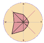
These diagrams resemble the petals of a flower, and thus became known as wind roses, though I have seen plots that looked more like daisies, tulips and even an iris or two. Many variations exist in this era of data analysis. The most common variant indicates the frequency of wind speed ranges from each direction. Other variations represent not only wind direction and speed frequencies around the compass but often relate wind directions with other weather occurrences such as frequency of fog or air pollution levels with the given compass directions. Early wind roses displayed 8-and 16-point roses for ease of reading them below decks in early sailing ships. More elaborate map roses showed 32 points for the classically named wind directions. For years, weather records only observed wind directions by the 8 or 16 point compass, but today, digital reporting of wind direction to the nearest degree allows roses to be constructed with a level of detail depending on the application. A wind rose can display any time period desired, from a single day to decades, but the most common indicate prevailing winds for the given location over the climate normal period of 30 years. Below is an example (left hand panel) of a basic wind rose constructed from an 8-point compass, the four cardinal directions (N, E, S, W) and the four intermediate directions (NE, SE, SW, NW). Each arm or petal of the rose covers wind directions falling within plus-or-minus 22.5 degrees from the central direction (e.g., NW). Wind roses lose some of their flowery demeanor when statistics are added to the rose such as the wind rose with speed intervals (right hand panel) where the frequency of wind speed categories (indicated by the width of the line) within that particular direction are plotted. 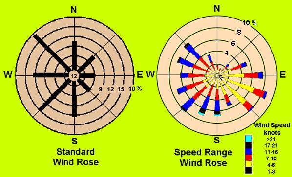 History of the Wind RoseThe wind rose has been with us for millennia, the first attributed to pre-Christian times. Some historians believe the Etruscans used an eight-point wind rose as early as the 4th Century BCE. Also in this century, Timosthenes, a chief pilot of the Egyptian fleet, devised a wind-rose for his navigation maps.
One of the earliest physical benchmarks is the famous Tower of the Winds which stands in Athens. Constructed around 50 BCE, by the Greek architect and astronomer Andronikos of Kyrrhos, the octagonal tower shows each of the eight "wind gods" on the side of the tower from which the blow. For this reason, meteorologists continue to speak of winds in terms of their origin, not their destination — e.g., a "westerly" wind blows from west to east.
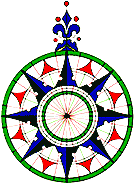
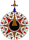
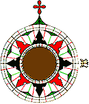
The compass rose (as the wind rose was known on early navigation charts) became common on charts and maps beginning around the 14th Century. The most elaborate wind roses had 32 points, simple, multiple bisections of the four cardinal wind directions, that kept with the tradition of the 32 classically named winds. Maritime historians credit 15th Century Portuguese navigators with improving the rose to a sixteen-point wind rose as they ushered in the golden age of maritime exploration. The 16-and 8-point roses were far more legible for mariners who often had to read these charts in dim light and bad weather on heaving ship decks. Adding colours and quickly recognized symbols aided in the chart's clarity. No standard format existed for drafting compass roses, so each cartographic house produced their own stylization. For example around the time of Columbus' voyages, Portuguese map-maker Pedro Reinel drew the first 32-point compass rose with a fleur de lis symbol pointed North — derived from a north arrow — and letter T, for Tramontana, a cool northerly Mediterranean wind. A Maltese cross denoted East because that direction had religious and cosmological significance (the direction of Jerusalem). The eight prime compass points were coloured black, the intermediate half-directions blue or green, and the quarter winds in red.
Wind roses from these earlier times were not only useful tools for mariners but often were also elaborate works of graphic arts. Today, most wind roses are utilitarian in their design, simple polar graphs. But there are interesting, supersized wind roses that are so common, you might not recognize them. Where are they? If you travel by air, look at the airports you pass over. Their runways are aligned in the directions of the most frequent winds, and thus form the main arms of a partial wind rose on the ground. The Weather Doctor's Weather Almanac By Any Other Name: The Wind Rose
|
|||||||||||||||
 |
To Purchase Notecard, |
Now Available! Order Today! | |
 |
 |
NEW! Now |
The BC Weather Book: |


 Strictly defined, the wind rose denotes a class of diagrams designed to display the distribution of wind direction experienced at a given location over a period of time — long for a climatological record of prevailing winds or short to show wind character for a particular event or purpose. The most common wind rose consists of a circular (polar) graphic plot from which, usually, eight or sixteen lines emanate, one for each compass point. The length of each line is proportional to the wind frequency from that direction over the period of record — the longest arms of the rose corresponding to the most frequent wind directions. Commonly, the frequency of calm conditions is shown in the rose's center. The wind rose built around a continuous 360-degree circle provides a visual continuity not found on linear bar charts or line graphs.
 For many reasons including regional wind climatology, wind names and their compass directions were not fully standardized for many centuries. Many credit Homer with naming the four principal winds — North, South, East and West — and providing a mythology for each. Boreas, dressed in a heavy cloak, signified the cold character of the North Wind so the wind rose pointed North. Boreas and Zephyrus, the best known, blew from the North and West; Notos and Apeliotes flowed from the South and East, respectively. Classic literature describes thirty-two wind characteristics, but generally only eight were practically recognized for early navigation.
 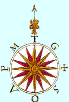 By 800 CE during the reign of Charlemagne, the now familiar intermediate compass points, NE, SSW, etc. were adopted. Throughout the Mediterranean region during the Middle Ages, the directional winds were commonly known as tramontana (N), greco (NE), levante (E), sirocco (SE), ostro (S), libeccio (SW), ponente (W) and maestro (NW). On old sailing maps known as portolan charts, the initials of these winds (T, G, L, S, O, L, P and M) can be found around the edge of the compass rose. Before the end of the 13th Century, Italian cartographers published a series of cartas (maps). One, the oldest maritime map of the Mediterranean, the Carte Pisane plotted a system of wind-roses for a grid, with land features by bearings and distances.