Weather Almanac for November 2004
BRITISH COLUMBIA:
LAND OF A BILLION CLIMATES

As many of you know, I live near the southern tip of Vancouver Island, off the British Columbia coast. The
greater Victoria region is nestled in a major rainshadow region comprised by the island mountains to the north
and west, Washington's Olympic Mountains to the south, and the continental coastal ranges to the east. Our
climate is cool Mediterranean and the weather is dominated by the influence of the northeast Pacific. But if
you travel across to the continent, you will find climates in the province ranging from coastal rainforest to
interior desert to alpine tundra.
The Province of British Columbia is a large place, so large in fact, that if it were an independent nation, it
would rank 31st in total area. It is also a varied landscape with ocean coast, several parallel mountain ranges,
a comparatively flat interior section and a spread over 11.5 degrees of latitude and 25 degrees of longitude.
Its terrain ranges from sea level to elevations exceeding 4000 metres, and includes shoreline, islands, long and
tall mountain ranges, relatively flat plateaus, a portion of the Canadian prairies, mighty rivers, dense forests,
and tundra, barren rock and icefields. The province's six distinct topographical regions are show on the accompanying map.
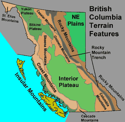
British Columbia Topographical Regions
The range of BC environments is unequalled across the rest of Canada, within which live a diversity of plant
and animal species also unmatched in any other province. The interplay of mountains, climate, and standing
and running water bodies create a biological diversity of innumerable micro-habitats that have isolated many
species from populations of their nearby relatives. We have lush temperate rainforests and a small region of
desert linked with the Great American desert that runs from BC south to Mexico.
The most prominent factors affecting the weather and climate here arise from the sun (of course) and the great
expanse of the Pacific Ocean. The interplay of the sun and atmosphere with the series of nearly parallel,
northwest-southeast mountain ranges results in a nearly infinite number of microclimates and micro-weather
variations: a billion is not an exaggeration, but perhaps an understatement. They can literally be different on
the other side of the mountain.
Geography, Topography and Climate
The Pacific Ocean shapes the province's weather and climate by providing much of the moisture that falls as
rain and snow. During the winter, its relatively warm surface waters delay, and even prevent, icy winter
weather from reigning over much of coastal and southern British Columbia. Therefore, these regions enjoy
very mild winters particularly when compared to the harsh conditions felt across the rest of Canada at similar
latitudes, or even further south. On the flip side of the year, the ocean waters are relatively cool giving mild
summer conditions to coastal British Columbia, particularly when compared to desert heat temperatures
experienced in the arid interior regions but a few hundred kilometres eastward.
The Pacific can also be a very unpacific ocean during the colder months when strong storms born over the
Gulf of Alaska send wave after wave of heavy weather — gale winds and copious rainfalls — onto the coastal
region and toward the interior. These storms water the great temperate rainforests of western British
Columbia and heap copious snowfalls on the high mountains that provide excellent ski and winter sport
conditions.
Mountain slopes and orientations expose different faces to the sun and wind currents throughout the year, and
thus their surfaces vary greatly in their ability to capture solar energy and precipitation. The lofty heights of
the Coast Mountains detain the moist Pacific air masses rushing inland and wring out much of their moisture
before allowing its entry into the interior and east toward the Rockies. As a result, the annual precipitation
generally decreases as we move inland from the coast. When the Pacific air finally leaves British Columbia it
is dry, leaving the Canadian prairies to the east with generally dry annual conditions. At the same time, the
great mountain expanses restrict the flow of arctic air masses across the southern province, so that coastal
regions are often spared frigid outbreaks.
The interplay of weather forces and terrain results in climate regions in the province that range from marine to
subarctic. Despite the billions of microclimates we find when we look with a detailed eye, these micro-variations fit within larger climate pictures with enough commonality to allow the definition of six climate
zones. Of these, five are separated into more or less parallel bands as we move off the Pacific waters and
across the mountains heading eastward to Alberta. For one climate regime, however, we must move upward,
into the summit regions of the highest mountains where Alpine climate realms have greater commonality with
each other and the high Arctic than with their slopes and foothills.
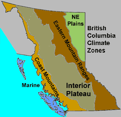
British Columbia Climate Zones
The British Columbia climate regions denoted in the accompanying map from west to east are:
- the Marine,
- the Coastal Mountains,
- the Interior Plateau,
- the Eastern Mountain Ranges,
- the Northeast Plains.
The sixth, the Alpine Zone climate type is scattered across the province. For the first four climate regions
there can also be a distinct north-south spilt within them. In general (though attempts at being too general fall
apart in BC), annual conditions among these zones show annual temperatures dropping as one moves north,
east and up. Annual precipitation also decreases eastward and decreases northward east of the Coastal
Mountain ranges.
A Land of Extremes
British Columbia is a land of weather and climate extremes. In the full Canadian climate picture, British
Columbia can boast of being "in the medals" for most categories of least or most, highest or lowest,
particularly if the subarctic territories are excluded for winter extremes and dryness. (For a map showing locations of the sites mentioned below, see the end of this article.)
Where BC is the undisputed X-champion for precipitation. Its list of Canadian precipitation records
includes:
- Greatest annual average precipitation: Henderson Lake, 6,655 mm;
- Greatest precipitation-one year: Henderson Lake, 9,479 mm in 1997;
- Greatest precipitation-one month: Swanson Bay, 2,235.5 mm in November. 1917;
- Greatest precipitation-24 hours: Ucluelet Brynnor Mines, 489.2 mm on October 6, 1967;
- Greatest average annual snowfall: Mt. Fidelity, Glacier National Park, 1,433.0 cm;
- Greatest snowfall-one season: Revelstoke, 2,446.5 cm, 1971-72;
- Greatest snowfall-five-day period: Kitimat, 246.2 cm on 14- January 18, 1974;
- Greatest snowfall-24 hours: Tahtsa Lake, 145 cm on February 11, 1999;
- Greatest snow on the ground any month: Whistler Roundhouse, 450 cm;
- Least average annual snowfall: Carnation Creek, 20.4 cm;
- Least average annual precipitation (outside the arctic territories): Ashcroft, 206 mm.
The average precipitation annually falling on Henderson Lake, on Vancouver Island, exceeds that falling on
the wettest Canadian location outside British Columbia — Burgeo, Newfoundland with 1,700 mm — by almost
a factor of four. The annual average snowfall at Mt. Fidelity in Glacier National Park is more than twice that
measured in the second-ranked province Alberta (643 cm).
Prince Rupert is Canada's wettest city (2593 mm precipitation per annum) while Kamloops is the nation's
second driest city (279 mm). Victoria (44 cm), Duncan (46 cm), Vancouver (48 cm), and Abbotsford (64 cm)
hold down the first four national placements for cities with lowest average annual snowfall totals. Despite its
low annual snowfall, Victoria ranks fourth in the greatest 24-hour snowfall ever recorded with 65 cm. Only St
John's, Fredericton and Moncton on the Atlantic Coast have experienced greater single snowfalls.
 Victoria is
also the only Canadian city west of southern Ontario to receive 50 cm or more centimetres of snow in one day
. . . a situation that has happened three times (1916, 1923, 1996)! Victoria is
also the only Canadian city west of southern Ontario to receive 50 cm or more centimetres of snow in one day
. . . a situation that has happened three times (1916, 1923, 1996)!
Prince Rupert leads the list of cities in annual number of hours of overcast or mostly cloudy skies (more than
eight-tenths of the sky covered) with 6146 grey hours. Prince Rupert openly boasts of its ranking as "The
Cloudiest and Wettest City in Canada." Only 1229 hours each year there can be called sunny, and measurable
precipitation falls on 240 days annually.
British Columbia's hottest recorded maximum temperature was 44.4oC on July 16, 1941 at both Lillooet and
Lytton. This ties British Columbia for second among Canadian provinces/territories with Manitoba (behind
Saskatchewan's national record of 45.0oC). British Columbia is home to the site with the warmest annual
temperature in Canada: Sumas Canal in the lower Fraser Valley at 10.7oC. Chilliwack, also in the lower
Fraser Valley, at 10.5oC is Canada's warmest city. Kamloops at 26.9oC has Canada's warmest urban summer.
Prince Rupert, in contrast, has the coolest urban summer: 15.7oC, over 3 degrees cooler than Yellowknife in
the Northwest Territories.
For the coldest temperature, the measurement of -58.9oC at Smith River on Jan. 31, 1947 ranks third. The
reading occurred during a frigid week in 1947 which saw Snag in the Yukon plummet to -63.0oC, the North
American record for cold.
But There Is Much More
 There is so much to say about the variety of British Columbia weather that this brief essay only scrapes the
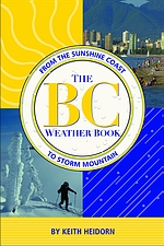
surface. I could write a book about the topic....Actually, I have and it was released last month: The BC
Weather Book: From the Sunshine Coast to Storm Mountain published by Fifth House Ltd. (ISBN: 1-894004-89-2). While it may not be on many bookstore shelves outside the province, it can be ordered from Amazon.ca (click here). This essay was derived from the material presented therein. There is so much to say about the variety of British Columbia weather that this brief essay only scrapes the
surface. I could write a book about the topic....Actually, I have and it was released last month: The BC
Weather Book: From the Sunshine Coast to Storm Mountain published by Fifth House Ltd. (ISBN: 1-894004-89-2). While it may not be on many bookstore shelves outside the province, it can be ordered from Amazon.ca (click here). This essay was derived from the material presented therein.
Written by
Keith C. Heidorn, PhD, THE WEATHER DOCTOR,
November 1, 2004
The Weather Doctor's Weather Almanac British Columbia: Land of a Billion Climates
©2004, Keith C. Heidorn, PhD. All Rights Reserved.
Correspondence may be sent via email to: see@islandnet.com.
For More Weather Doctor articles, go to our Site Map.
I have recently added many of my lifetime collection of photographs and art works to an on-line shop where you can purchase notecards, posters, and greeting cards, etc. of my best images.
Home |
Welcome |
What's New |
Site Map |
Glossary |
Weather Doctor Amazon Store |
Book Store |
Accolades |
Email Us
|


|