| Home | Welcome | What's New | Site Map | Glossary | Weather Doctor Amazon Store | Book Store | Accolades | Email Us |
 | |||||||||
Weather Almanac for August 2004THE AMERICAN MONSOONWhen we hear the word monsoon, often the first image that comes to our mind is one of intense, continual rains in India and South Asia. But the roots of the word come from the Arabic word mausim, which means "season" or "wind-shift" — first used by Arabic navigators to describe the seasonal wind patterns of the Arabian Sea which blow for six months from the southwest, and six months from the northeast, driven by the dramatic seasonal temperature differences between land and sea. Thus, the correct definition of monsoon is any wind that reverses its direction seasonally. Climate research has now identified monsoon patterns in Europe, Africa, and the western coasts of Chile, Mexico and the United States. While the Arabia monsoon is mostly distinguished by wind direction shifts, over the Indian subcontinent and southern Asia, the monsoon is usually differentiated by wet and dry periods, the classic Indian rains (though the general atmospheric flow pattern does make the characteristic shift). As an example, the Indian town of Cherrapunji averages over 11, 000 mm (430 inches) each year. Over a metre (39 inches) falls in each of the months from May through September, but under 100 mm (4 inches) during December, January and February. Less known is the American Monsoon of the US Southwest and northern Mexico, which also goes by the name of Southwest Monsoon, Arizona Monsoon, and Mexican Monsoon. The changes in the atmospheric flow patterns associated with it bring tropical maritime air to combine high humidity with summer's intense solar heating. As a result much of the annual rain to the southern Sonoran desert comes during this period. 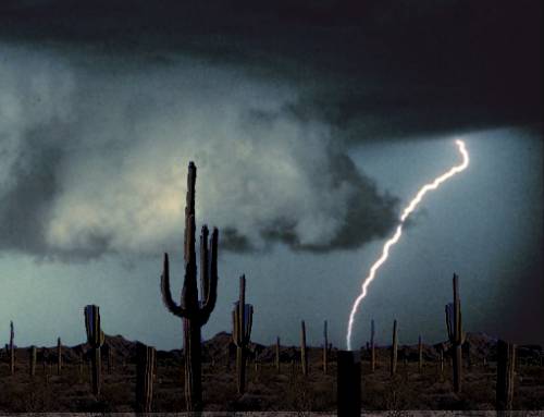 Monsoon FormationThe North American monsoon begins to grip the region in early July and persists into mid-September. The seasonal change in air flow patterns — swinging to the south to southeast — associated with the monsoon brings moist tropical into the desert regions. And although precipitation amounts are a drop in the bucket compared to those in India, a high percentage of the region's annual total falls during monsoon season. For much of the year, over the southern regions of Arizona, New Mexico and northern Mexico, the winds aloft flow from the west to northwest as the 50 kPa (500 mb) subtropical ridge lies over northwest Mexico. Its June position, shown in the figure, causes the hot and dry weather conditions experienced over the region, conditions that will soon trigger the onset of the American Monsoon. 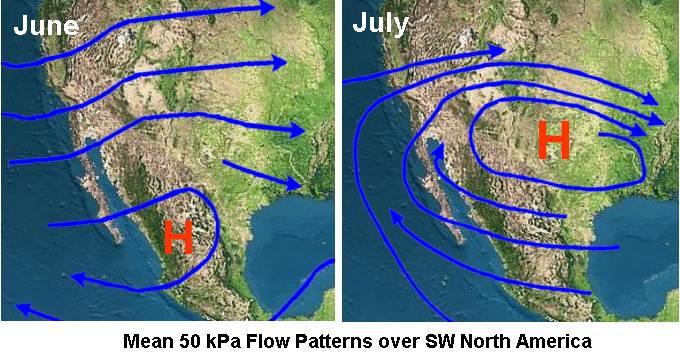 In July the 50 kPa subtropical ridge normally migrates northward with its center located over west Texas and New Mexico. This shifts the flow to east to southeasterly in the mid-atmosphere and often brings onshore flow from the Gulf of California, causing a dramatic rise in humidity and thunderstorm activity over northwest Mexico and southern Arizona. The shift begins, on average, around July 6 in southern Arizona — give or take a week. Monsoon conditions then migrate northward over the following weeks. Sea surface temperatures in the Gulf of California are strongly linked to the intensity, timing and extent of the monsoons in North American and Mexico. The summer rainfall pattern does not begin until the surface water temperature in the Gulf of California warms above 26oC (79oF). As with the Indian and Arabian monsoons, intense summer daytime heating over the Sonoran Desert of Mexico and Arizona forms a large surface low-pressure cell over the region, a thermal low. This low draws moist tropical air northward from the Gulf of California, triggering thunderstorms as it is lifted by the mountains and daytime solar heating. Moisture is also draw in from the Gulf of Mexico. Arizona meteorologists operationally define monsoon conditions when daily dew points average 12.8oC (55oF) or higher for a prolonged (3 consecutive days or more) period. The Arizona monsoonal circulation does not produce thunderstorms every day but rather occurs in a pattern that has "bursts" and "breaks," according to Penn State climatologist Andrew Carleton. He defines these patterns as: Burst: "A movement of a weak trough in the upper level westerly wind into the southwest U.S. which spreads upper level cold air into the region. In the lower levels of the atmosphere, strong surface heating and southerly winds will transport moisture into the region. This creates intense atmospheric destabilization and leads to widespread thunderstorm outbreaks." Break: "An enhanced ridging of the Pacific subtropical High Pressure moves inland, effectively cutting off the moisture flow and stabilizing the atmosphere." On a typical Arizona Monsoon day, thunderstorms will initially develop in the early afternoon over the higher mountains and the Mogollon Rim. Rain-cooled air from these thunderstorms descends from the high country and into the desert. Acting like a cold front, this mesoscale outflow induces the hot desert air to rise, again producing thunderstorms. Over the higher deserts, they usually occur during the mid to late afternoon, while over the lower deserts storm activity is most common during the late afternoon and evening. Generally, thunderstorm activity ceases around midnight. Monsoon thunderstorms can bring heavy downpours, very strong and gusty winds, hail, blowing dust and, of course, lightning. When intense downpours fall into the mountainous terrain, flash flooding is common across the desert as dry washes quickly fill up with the rainfall and its runoff. Monsoon Impacts
At times, high moisture levels associated with hurricanes and tropical storms in the eastern Pacific can be caught in the monsoon flow regime and affect the desert region. When this occurs, continuous heavy rains can persist for 24 to 48 hours or longer. The most noteworthy example occurred during the Labor Day storm of 1970 (September 4-5) when the remains of tropical storm Norma produced severe flash flooding in central Arizona, resulting in 23 deaths, fourteen near campgrounds at the headwaters of Tonto Creek when visitors tried to evacuate. The 24-hour peak rainfall of 290 mm (11.4 inches) at Workman Creek, about 60 miles east northeast of Phoenix, established a state rainfall record. The deluge caused rivers in central Arizona to rise 1.5 to 3 metres (5 to 10 ft) per hour, sweeping cars and buildings as far as 50-65 km (30-40 miles) downstream. Recent studies have linked strong American Monsoons to summer drought in the Midwest and relatively wet summers in the Southeast, though the link remains unclear. Heavy winter precipitation in the southwestern mountains presages a weak monsoon season as does a mature El Niño event. During La Niña events, however, a strong monsoon brings wet conditions to the Southwest while the Great Plains are dry. The Weather Doctor's Weather Almanac The American Monsoon
|
|||||||||
 |
To Purchase Notecard, |
Now Available! Order Today! | |
 |
 |
NEW! Now |
The BC Weather Book: |


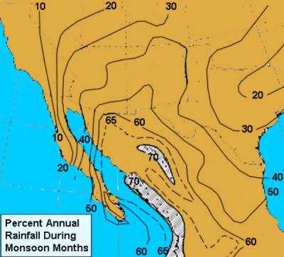 During the monsoon season, the region receives most of its annual precipitation, approximately 35 to 45 percent for Arizona and New Mexico and 60 percent for northern Mexico. Like Asia, a similar seasonal rainfall situation occurs over much of northern Mexico. For example, Acapulco rainfall totals 1316 mm (51.8 inches) during the months of June through October (more than 230 mm / 9 inches each month except October), while only 838 mm (3.3 inches) falls during the rest of the year.