| Home | Welcome | What's New | Site Map | Glossary | Weather Doctor Amazon Store | Book Store | Accolades | Email Us |
 | |||||||||||
Weather Almanac for November 2003HERE COMES THE PINEAPPLE EXPRESS
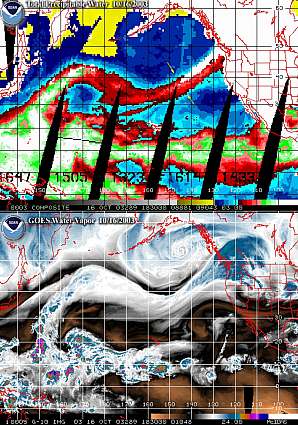
But then, about mid-October, the atmosphere changed its mood. Following a summer when drought over much of the West Coast had been of grave concern and forest fires raged through British Columbia, Washington and Montana, the word on everybody's mind during the early autumnal days continued to be fire. Little did we know that October would bring another f-word to our lips: flood. The switch from dry weather under dominant Central Pacific high pressure to cloudy, damp weather under Gulf of Alaska low pressure regimes is typically rapid here in the Pacific Northwest. One week we bask in the late summer-like weather of early Autumn, the next, we begin to grow moss and develop rain-wrinkles as the winter rainy season begins. So it is not unusual for conditions to change quickly...but rarely is the flip as intense as during October 2003. The devil behind this year's extreme sogginess is the benignly named airflow regime, the Pineapple Express. Tropics BornAt times, the Pineapple Express is grouped into that gang of named extratropical storms, going by aliases such as the Alberta Clipper, the Nor'Easter and the Colorado Low. But, unlike the aforementioned, the Pineapple Express isn't really a storm type of its own. It is more a fuel source, like Oklahoma Crude, a superhighway or pipeline which transports very (and I do mean very) moist tropical air from the subtropical Pacific Ocean to the northwest coast of this continent. When the Express turns bad, it typically does so while hanging around the fringes of the Gulf of Alaska storm gang as they assault the coastal mountain ranges of North America. The Pineapple Express is actually the Subtropical Pacific Jet Stream, a very moist, warm channel that has ventured further north than usual. Being tropics-born, this Pacific airstream has been linked to an origin in the vicinity of the Hawaiian Islands, the land of the Pineapple, and thus, the appellation, the Pineapple Express, arose among local meteorologists and the media. The Pineapple Express airstream holds prodigious amounts of water vapour in its balmy flow and often arrives on the West Coast still warm after its thousands of kilometres journey. A mild saturated air mass 10 Celsius degrees (18 Fahrenheit degrees) warmer than a cooler airmass can carry nearly twice the moisture. The accompanying satellite photo of precipitable water shows how striking this narrow flux of moist air is as it steams toward the coast.
When that moisture stream is either incorporated into a Gulf of Alaska low pressure system or forced to surmount the coastal ridges from Northern California to Central British Columbia, much of that water vapour is turned into liquid, or perhaps solid forms, and deposited over the coastal region. Though rainfall is properly measured in millimetres, during Pineapple Express events, it often falls by the centimetre; when rain becomes snow at higher elevations or in collision with cold, continental surface air, the snowfall, usually measured in centimetres or inches, is more easily appreciated if metres or feet are used. The Pineapple Express typically rides the mainline into the Pacific Northwest several times each cold season. However, it may become established over the region for much of the season, such as the 1996-97 winter, producing very wet winters from northern California to British Columbia. Regardless of frequency, the Pineapple Express usually brings the wettest winter storms to strike the region. Do You Have Plans For An Ark?Over a little more than a week in mid-October 2003, the Pineapple Express appeared to have answered the summer-long prayers of those in British Columbia and Washington all at once. One could have done a booming business, from south of Seattle to north of Vancouver including Vancouver Island, selling plans for an ark. We were fortunate the rains did not last the forty days and forty nights suffered by Noah and friends. Just under a fortnight was enough time to bring water gushing down stream and river beds, dry for so many previous months, in destructive torrents. Victoria and Seattle both shattered all-time, 24-hour rainfall records, and flooding and washouts became the prime news topics replacing fire which dominated the media only three months ago. The heaviest rains struck Vancouver Island and the adjacent Sunshine Coast of the mainland over several intense days beginning October 15. Victoria received 136 mm (5.4 inches) on October 16, and conditions up-island were as bad or worse, even for locations that measure annual rainfall by the metre and hold many of Canada's precipitation records. The heavy rains hung around for several days as the Pineapple Express danced over the Georgian Basin. By the time round one was finished, Victoria had accumulated 227 mm (9.0 inches); the Malahat, an undulating stretch of mountainous terrain along the western shore of the Saanich Inlet received 271 mm (10.8 inches); 320 mm (12.7 inches) fell on the mid-Island town of Port Alberni. On the mainland, accumulations were equally high over several days: Abbotsford, 215 mm (8.53 inches); Vancouver (Harbour), 242 mm (9.6 inches); Squamish, 411 mm (16.3 inches). On Vancouver Island, flooding was localized as runoff from the highlands overflowed stream beds. In Sooke, west of Victoria, flood waters met with incoming high tide, and the stand-off backed up flood waters into several neighbourhoods. Some roads were washed out, pumpkins floated in fields, and wells were contaminated. Climatologists called it a hundred-year rainfall event. 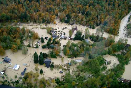 [Photo courtesy, District of Squamish, 2003] North of Vancouver along the no-longer Sunshine Coast and into the Coastal Mountains near the winter resort region of Whistler, the heavy rains reached 600 mm during the initial onslaught. Several sections of the Sea-to-Sky Highway were washed out along with other roads and rail lines that service the region. One section gave way as a car passed over, killing two of the three occupants. The inland towns of Whistler, Squamish and Pemberton were isolated, and nearly 800 residents were forced from their homes by floodwaters. At one Squamish farm, many pumpkins escaped their Halloween destiny by riding the flood waters and plunging into the Lillooet-Fraser River system, heading toward Vancouver and then perhaps out to sea. 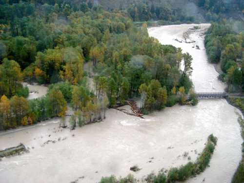 [Photo courtesy, District of Squamish, 2003] When the rains slackened in British Columbia, however, the mischief of the Pineapple Express was not over. On October 20th, the track of the Express slipped south, and northwestern Washington received the full brunt of the rainfall. Sea-Tac Airport, south of Seattle, shattered its all-time, 24-hour rainfall record with 5.02 inches (126.5 mm), and it was only third on the list of rainfall records set that day. At Shelton, 7.20 inches (181.4 mm) fell, and Hoquiam gathered 5.39 inches (135.8 mm). Five other stations recorded record daily rainfalls for October including the communities of Bellingham, Port Angeles and Olympia. Once fallen, the water rushed down the streams and rivers of western Washington, prompting flood warnings to be issued for at least eleven rivers. For example, the Skagit River, about 60 miles (96 km) north of Seattle, crested at a record 42.2 feet (12.86 m) — more than 14 feet (4.2 m) above flood stage. The flooding of the river forced more than 3,000 Skagit County residents out of their homes. 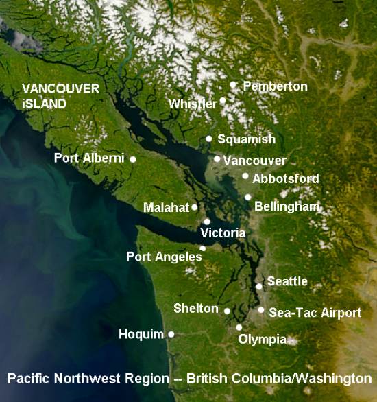 By October 23, the rains had abated over most of the regions, and flooded rivers returned to their beds, leaving clean-up crews to rebuild roads and lives. The Pineapple Express sought new destinations, but we know it will return. Learn More From These Relevant Books
|
|||||||||||
 |
To Purchase Notecard, |
Now Available! Order Today! | |
 |
 |
NEW! Now |
The BC Weather Book: |


 A month ago when I was considering topic ideas for this month's Almanac, I was influenced by our long string of clear days with gorgeous skies that delighted the sky and star watcher in me. August had me looking toward the east to see Mars rise, the September Harvest Moon shone brightly through my window. And I was treated to vivid sunrise and sunset twilight arches, the initial chosen topic for November when both dawn and dusk are so readily available for viewing.