| Home | Welcome | What's New | Site Map | Glossary | Weather Doctor Amazon Store | Book Store | Accolades | Email Us |
 | |||||||||||
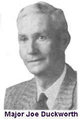
Weather Almanac for July 2003FLYING INTO THE EYEEach year with the advent of the Atlantic hurricane season, the 53rd Weather Reconnaissance Squadron of the US Air Force Reserve, known around the world as the Hurricane Hunters, prepares for another season of activity. Their ten Lockheed-Martin WC-130 aircraft are specially instrumented for the dangerous task at hand. 2003 marks the 60th year in which aircraft have flow into the fury of hurricanes. You may be surprised to learn that the first intentional flight into a hurricane was not a carefully planned mission, but the spur-of-the-moment decision by US Air Corps Colonel Joseph Duckworth. It began as a bet! The Surprise Hurricane of 1943In 1943, the second year of American involvement in World War II changed many normal routines and practices in the United States. One of these was the way in which Americans were informed about the weather. Shortly after the bombing of Pearl Harbor in 1941, the Office of Censorship advised radio stations to omit all mention of weather, except as directed by the US Weather Bureau. Even baseball announcers were instructed to avoid mentioning the weather during ball games. Daily newspapers carried only vaguely worded forecasts, and little news of weather disasters. In late July of 1943, a tropical depression formed off Burrwood, Louisiana and drifted westward toward the Texas coast. The depression would quickly intensify to hurricane force and take aim on Galveston Bay. Its presence in the Gulf waters was deduced by New Orleans forecaster W.R. Stevens from coastal upper air data. Because of suspected German U-boat activity in the Gulf of Mexico, all marine radio broadcasts were silenced. The muffling also extended to include weather observations and reports, even if severe conditions like a tropical storm were involved. Weather Bureau forecasters at the time relied almost exclusively on ships reports and various weather offices in coastal cities and airports for the information used to produce routine forecasts and storm warnings in the coastal region and offshore waters. 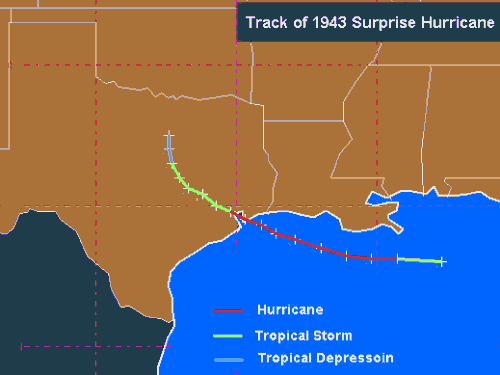 Lew Fincher of E. I. DuPont De Nemour's, Inc., and Bill Read of the Houston/Galveston Area National Weather Service (NWS) Office recently prepared a study of this storm and found very little information due to the government censorship. Their work still stymied by the war secrecy: "There is virtually no reference to the storm in records kept at the local Houston NWS office or the former Galveston NWS office. Again, war era regulations did not permit release of records kept at these offices and we were informed anecdotally that in all likelihood any records taken would have been classified and shipped to Washington," they wrote. I can only imagine the dilemma that must have gone through the minds of local weather officials as the storm apparently bore down on Galveston Bay. The Great Galveston Hurricane of 1900, which killed an estimated 8,000, was less than fifty years in the past. A 1915 hurricane tested the Galveston seawall built in response to the 1900 storm and killed more than 275 people. Now a storm of unknown strength again bore down on the coast city but as it approached, local forecasters had little information to work with and were restrained in what they could say about the situation. The Galveston�Houston area was the location of many oil refineries crucial to the war effort, and news of an impending hurricane strike (and its aftermath) could have aided the enemy. The first mention of an impending storm surfaced in a newspaper story on Monday morning, July 26, 1943. Headlined "First Storm Warning of the Season," the article reported a storm with strong, likely gale-force, winds lay offshore and was moving west at 10 mph (16 km/h). Small craft were advised to stay in port, but in a statement by the Houston Weather Bureau Meteorologist-in-Charge, C. E. Norquist, he advised the papers: "Don't get the people disturbed by use of the word hurricane. As matters now stand it is a small tropical disturbance. If it gets worse, we will let everyone know in plenty of time." Tuesday morning dawned, but the public advisories on the storm situation remain virtually unchanged. When the storm struck land around noon, the public was taken by surprise. As a consequence, this storm from pre-hurricane-naming days earned the name "The Surprise Hurricane of 1943." But it was not a complete surprise to the government and military. Bryan Field, TexasLocated near College Station, Texas about 125 miles (200 km) inland from Galveston Bay, Bryan Field was the site of the Army Air Corps instrument flying program. At the time of the storm, a group of experience British pilots, many aces from the air war over Europe, were training in the new field of instrument flying under lead instructor, Major Joe Duckworth, a former Eastern Air Lines pilot who had been reactivated in 1940 to develop the instrument flying program.
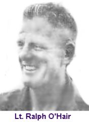
The Air Corps command at Bryan Field had learned through military channels of the approaching storm and, fearing damage to their AT-6 Texan Trainer fleet and other aircraft, they ordered the aircraft evacuated to bases further north. Upon hearing word of the storm and the evacuation of the Texans, the British flyers, miffed at having to fly the Texans rather than the top American fighter planes, began ridiculing their perceived frailty of the training aircraft. Unfortunately, few if any Brits had ever experienced, let along flown near, a true hurricane. Many apparently confused hurricanes with big thunderstorms. The Bet and the FlightIn the mess hall during breakfast, Duckworth finally reached his fill of the British giggling and whining and ridiculing of the AT-6 aircraft as well as their belief it was a frail plane. He defended his planes saying they could fly in any weather. The Brits dared him to prove it, so he offered a wager that would prove both the AT-6 and his instrument flying techniques were sound. He would fly one into the teeth of the hurricane and return safely. The bet was accepted. A highball to the winner! Don't be mislead, however, by the impulsive nature of the proposed flight. Major Duckworth had long firmly believed that no weather was unflyable when the pilot was competent in instrument flying techniques. And no one on that base was more competent or experienced than Joe Duckworth to fly such weather. Major Duckworth needed a navigator. Across the table sat the only navigator at the airfield that morning: Lieutenant Ralph O'Hair. Duckworth asked O'Hair to volunteer to accompany him on the risky, unsanctioned flight. O'Hair was shock at the invitation but agreed out of the respect he had for Duckworth's skill as a pilot. "There was no one in the Air Force who could have ordered me to do that; I love life too much." O'Hair later recalled. Convinced that Headquarters would never sanction the flight due to the high risk to the aircraft and the crew, Duckworth and O'Hair decided not to seek official permission. As they prepared for take-off O''Hair worried that if their single engine failed for some reason, they would be in deep trouble. The hurricane had just come ashore when they took off around noon, packing 80 to 100 mph (130-160 km/h) winds. Approaching the storm at an altitude of between 4,000 and 9,000 feet (1200 to 2700 metres), the two-man crew felt the scud-filled sky became very turbulent. O'Hair would later describe the flight as "being tossed about like a stick in a dog's mouth" without much chance of getting away from the grip of the storm. Flying through the dark storm-wall, they fought torrential rain and extreme, turbulent updrafts and downdrafts. "I was scared flying into the thing," said O'Hair, years later. "The water was very, very heavy. You could hear it in an AT-6. That was an awesome thing. The farther we got in, the darker it got."
The eye, according to O'Hair, was shaped like a leaning cone, extending nine or ten miles (fifteen to sixteen kilometres) across. Looking down they could see the countryside, confirming the storm had indeed moved inland. They radioed the Houston weather station reporting the latitude and longitude of the eye. After circling inside the eye a few times, they exited again into the dark overcast and heavy rains, following the radio compass home. "We were much more relaxed on the way back. We knew the �Alpha and Omega' of that hurricane." When they arrived back at Bryan Field, the weather officer, Lieutenant William Jones-Burdick, asked to be flow into the storm to make visual observations. O'Hair jumped out and Jones-Burdick jumped in. Duckworth then flew a second mission into the hurricane as Jones-Burdick took observations as they flew through the storm. 1715 (5:15 PM, CST): Heavy rain, strong rain static. That night the bet was paid and never more was heard a discouraging word on the sturdiest of the AT-6 trainer nor the value of instrument flying. A footnote to the story. According to Ivan Tannehill in his book The Hurricane Hunters, Duckworth told him that he discovered a year later that after his flight into this hurricane, several of his instructors and supervisors sneaked out and flown the same storm in B-25s. They had been afraid to tell Duckworth at the time since they did not have permission. The AftermathThe hurricane's eye moved inland across Bolivar Peninsula and eastern Galveston Bay just north of Galveston, reaching Houston by midnight. Maximum reported winds varied widely across the region. Peak gusts of 104 mph were measured at Texas City and 132 mph observed at Houston Metropolitan Airport (now Hobby Airport), Ellington Field, and Baytown. Winds above 85 mph were sustained in Houston for over two hours. Newspaper accounts reported rainfalls of 5 to 7 inches (127 to 178 mm) at many locations. La Porte recorded 17 inches (432 mm) while further east, near Port Arthur area over 19 inches (483 mm) was recorded. The storm continued slowly inland, but quickly lost strength and petered out near Dallas on the 29th. Though only a Category 1 (possibly a Category 2) hurricane, it did extensive damage to the region ($16.6 million). Nineteen lives were also reported lost. Many plants producing war materials were damaged from high winds and water. At the time of the storm, the huge Humble Oil and Refining Company at Baytown was the main producer of the Allied Forces' supply of aviation fuel, and its toluene production, an ingredient of TNT, was also vital to the war effort. With four large cooling towers demolished and other damage to the facility, production at the plant had to be suspended. Refineries at Texas City and Deer Park also saw their war production suspended, due to bad damage from the hurricane. The sum of hurricane damage caused major disruptions of war oil production. The government heavily censored news of this hurricane citing national security. The Axis Powers must not find out about the loss of war materials production. Reportedly, the FBI shut down the telegraph office in La Porte because a telegram had been sent describing damage from the hurricane. The only published news of the hurricane was limited to the two states affected, Texas and Louisiana. After this hurricane, however, public severe weather advisories were never again censored. War or not, the risk to human life was too great. Neither Duckworth nor O'Hair ever repeated their flight into a hurricane, but they proved it could be done. On August 7, 1944, the War Department created the first Weather Reconnaissance Squadron. The unit was activated three weeks later, although it was February 1945 before enough men and aircraft could be assembled to form an operational flight. In September 1945, a B-17 Flying Fortress flown by the 53rd Weather Reconnaissance Squadron made the first intentional reconnaissance mission into a hurricane. Hurricane flights soon became the primary mission for the 53rd Weather Reconnaissance Squadron which has been known as the Hurricane Hunters ever since. Learn More About Hurricanes From These Relevant Books
|
|||||||||||
 |
To Purchase Notecard, |
Now Available! Order Today! | |
 |
 |
NEW! Now |
The BC Weather Book: |


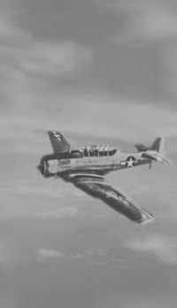 Blackness and wind shears characterized the inner third of the hurricane as the Texan approached the storm's eye. Suddenly, bursting through a showery curtain of towering, dark clouds, brightness filled the sky. Surrounding them were high cumulonimbus walls, below the ground, above fairly clear sky. They had broken into the eye of the hurricane. "What characterized that eye," recalled O'Hair, "was the relief that I felt; after what we'd been through, it was immeasurable."