| Home | Welcome | What's New | Site Map | Glossary | Weather Doctor Amazon Store | Book Store | Accolades | Email Us |
 | |||||||||||
Weather Almanac for December 2001A CHILLING WIND RUNS THROUGH METhis morning, an intense low pressure system centred just off the Washington coast is generating gale-force winds through the Strait of Juan de Fuca. The gales have whipped the waters off Victoria's Clover Point into high waves and stinging spray, merging sea with mottled grey skies. My glasses are flecked with salt spots as the spray hitting the lenses quickly evaporates in the wind. And although the air temperature remains a few degrees above freezing, I -- here to witness the tumultuous seas -- am chilled to the bone even in my heavy jacket. 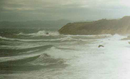 Under sunny skies and light winds, a brisk walk along the Beacon Hill Park shoreline at these temperatures might only require a jacket, or perhaps a thick sweatshirt. But this day, the wind blows so strong it plucks a handkerchief from my jacket pocket and sends it fluttering into the broom branches along the shore. The wind starts me shuddering, drawing heat from my body at a faster rate than my internal metabolism can produce. To keep my core temperature from falling too far from its nominal 37oC (98.6oF), my subconscious brain commands my large muscles to produce heat through motion. In response, my back, legs and shoulders start to shiver; my jaw joins in sympathy, making speech slightly less than intelligible. As I pull my jacket tighter around my neck, draw my toque further down my head (from where much body heat is commonly lost), and hunch my shoulders against the wind, I am reminded of my frigid morning walks to the bus during the extreme cold Ontario winters of 1976-78. In those days, the combination of wind and temperature produced windchill temperatures in the minus 40 range, and often lower, and I sought routes that minimized my exposure to the wind, pulling my parka hood out to protect my face.
Three factors determine the rate and degree of frostbite formation: subfreezing air temperature, wind speed and time of exposure. We can easily establish relationships between air temperature and time of exposure, but adding wind speed into the mix confounds the issue. What is needed is some numerical index that could readily be understood when hazardous conditions arose. Scientists saw the need to determine the degree of chilling impact of wind on the human body early in the twentieth century. The first windchill factor simply combined the temperature and wind speed by multiplying the number of Celsius degrees below freezing by the wind speed in metres per second. (The term windchill was coined by Paul Siple in 1939 in his doctoral dissertation Adaptations of the Explorer to the Climate of Antarctica.) Then in the late 1930s, Paul Siple and Charles Passel conducted research in the Antarctic to determine how quickly extreme conditions would produce frostbite on exposed skin. Siple's research determined the heat loss rates and times required to cool a volume of water to freezing under a variety of conditions. However, he soon realized that the resulting empirical equation had another use. By equating the heat loss rate for a given set of wind and temperature conditions, it was simple mathematics to calculate the equivalent temperature for lighter, near calm, winds. Siple called this equivalent temperature the windchill. Years later, the windchill temperature was touted to be the temperature that a set of wind and temperatures would "feel" like. This then became the prime use for the equation, and beginning in the 1960s, a form of Siple's equation for windchill became a regular part of winter weather reports and has remained so until this year. But, for many years, researchers had felt that the windchill concept needed to be altered. They argued that a beaker of water is hardly a good model of the heat-generating human body.
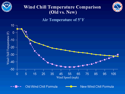
The equation for the new windchill index was accepted by Environment Canada and the US National Weather Service in 2001. On October 1, 2001, Canada officially began reporting the new windchill The Americans followed suit on November 1, using an Imperial unit version of the formula. Negotiations are underway to standardize this windchill index globally. [The former practice of issuing a windchill factor in watts per square metre used in parts of Canada will be dropped with the introduction of the new index.] Beginning this winter, therefore, those cold winter days might psychologically seem a little warmer, for the new windchill formulation does not plunge as rapidly with increasing winds as the older version. My minus 40 day has thus lost some of its bite as those combinations of wind speed and temperature would now produce a reported windchill in the minus 26oC (minus 15oF) range.
Before I finish, I want to address some misconceptions about windchill and its application. While the new windchill index corrected many of the problems of the Siple equation, two major misconceptions on the nature of windchill are likely to remain for some time. First, it is important to note that the windchill is not a temperature in the strict sense, but a temperature-like number that quantifies the sensation of cold. Thus, in Canada, it will be reported without the degree designation. But, in my mind, the most important misconception commonly held about windchill is that that when an air temperature above freezing and a strong wind combine into a subfreezing equivalent windchill temperature, water or other liquids will freeze. This is utterly false. The wind speed, however strong, does not change the actual air temperature. If we placed two identical thermometers side-by-side, one exposed to the wind and the other sheltered, they will read the same unless other factors such as radiation or moisture on the sensor are affecting one of them. Thus, no matter what the equivalent windchill temperature may be, the temperature of a living body (human or animal) or an inanimate object (e.g., a car radiator) exposed to the air will never drop below the actual air temperature unless wet (when evaporative cooling may lower the surface temperature). Therefore, exposed water or other liquids will not freeze unless the air temperature is below their freezing point. The impact of windchill on objects or liquid surfaces can lessen the time required for their temperatures to reach equilibrium with the ambient temperature, however. While the determination of windchill will reduced the number which is reported, cold is still cold. We shiver and shake as blustery winter winds rob our bodies of its core heat, and stress our systems. The danger of frost bite is ever present, particularly if we dress for fashion and not for winter protection. So, put on that toque or pull up that parka hood, the North Wind doth blow. For more on windchill, see the following Weather Doctor Articles: Cold Impacts on Human Health and Comfort For official Windchill information from the Canadian and American weather services, go to their sites listed below: Canada: Environment Canada's Wind Chill ProgramUnited States: New Wind Chill Temperature IndexLearn More From These Relevant Books
|
|||||||||||
 |
To Purchase Notecard, |
Now Available! Order Today! | |
 |
 |
NEW! Now |
The BC Weather Book: |


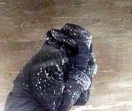 At extremely low temperatures or moderately cold temperatures with brisk winds, frostbite can attack exposed flesh in a matter of minutes. Minus 40 is the temperature on both the Fahrenheit and Celsius scales where exposing any skin to the cold is no longer safe. At this air temperature, or its windchill equivalent, skin can freeze almost instantly. At a temperature of minus 28oC (minus 18oF), flesh will freeze in 15 minutes or less.
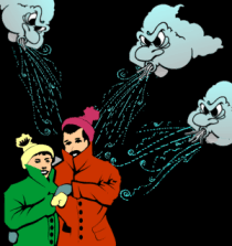 Intensive research over the past decade has lead to a new heat-loss model and windchill formula based on modern heat-transfer theory instead of Siple's simple field experiments. The new windchill was developed by researchers at Purdue University and Canada's Defence Civil Institute of Environmental Medicine in Toronto and tested in a special chilled wind tunnel with human subjects. The model, on which the new windchill is based, focuses on heat loss from an exposed human face. The face was chosen because it is the part of the body most often nakedly exposed to severe winter weather; the rest of the body is assumed to be clothed appropriately for the weather conditions.