| Home | Welcome | What's New | Site Map | Glossary | Weather Doctor Amazon Store | Book Store | Accolades | Email Us |
 | ||||||||||||||||||
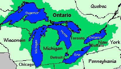
Weather Almanac for May 2000GREAT LAKES BREEZESAs many of my readers know, I was born in Chicago within ten miles (16 km) of Lake Michigan and until my relocation to Vancouver Island, I had lived 45 years within 50 miles (80 km) of at least one of the Great Lakes. For most of those years I was within a few hours drive of two or three of the Lakes.
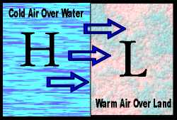
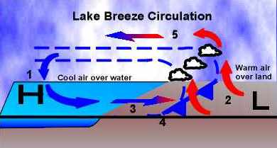
Only the shining, big sea waters of Gitche Gumee -- Lake Superior -- have never been within easy reach of my home. Lakes Michigan, Huron and its siamese twin Georgian Bay (that some consider the sixth Great Lake), Erie and Ontario have all had direct influences on the weather and climate around me through most of my life. And many an Autumn storm born of Mother Superior has slipped southward to bring rain, wind and snow into my weather picture. Each season brings slightly different lake influences on weather patterns within the Great Lakes basin. The basin lies under one of the major North American storm tracks and the interaction between weather systems and the Lakes' waters add a further dimension to life here. I believe the richest variety of weather found anywhere on Earth occurs in this region. In Autumn, the Lakes moderate the cold air that sweeps south from the arctic, thus extending the frost-free period further into the season and allowing many areas south of the Lakes to be prime fruit growing sectors. The Lakes often give birth or new life to storm systems during this season, and a few such storms have blown with hurricane force winds. [See The Winds of November in 1998 Almanac.] Late in the season, outbreaks of cold arctic air generate bands of clouds that sweep onto the shoreline, pelting inland regions with cold rain showers, ice and snow pellets, and finally snow showers and squalls. Winter brings an increased frequency of snow squalls as lake-effect snows develop within the howling cold air streams crossing the relatively warm lake waters. Under extreme conditions these squalls can last for days and bury areas under huge snow drifts. [See Lake-Effect Snowfall.] But in exchange, the moderation of the cold air mass often spares the lee shores from extreme cold temperatures. Lake influences in Spring and Summer can often knock much of the heat and humidity from tropical air moving northward from the Gulf of Mexico as it passes over the relatively colder waters. The Lakes' shorelines become popular recreation areas as the cool and drier lake air moves inland on lake breezes bringing refreshing relief from the heat of summer to the millions residing in the region. For a number of years, the influence of the lake breezes, which form along the Great Lakes' shorelines during Spring and Summer, were prime focuses of my professional attention. Lake breezes and their associated circulation systems can have a profound negative effect on air quality. During my years as a meteorologist with Environment Ontario, the lake breeze regime would often cause air pollution alerts in several Ontario locations by trapping industrial emissions within the stable lake air. The Lake Breeze and Lake Breeze FrontBasically, a lake breeze is a wind flowing off a lake onto the shore. Most meteorologists, however, use the term to define a special, local air flow situation known as the lake breeze circulation or lake breeze regime. (The lake breeze is similar to the sea breeze found along sea coasts. See Sea-Land Breezes.) The key conditions for the development of a lake-breeze circulation are light regional winds and a strong temperature contrast between air over the cold lake and that over the warm land. These conditions generally occur on Spring and Summer days when the sun shines strongly and winds from larger scale weather systems blow lightly. (Such a flow regime is considered a mesoscale flow, or perhaps a microscale flow on a small lake.)
[When the temperature situation reverses and cold air is found over land and relatively warm air over the water, a flow known as the land breeze may occur, blowing from off the land and over the lake.]
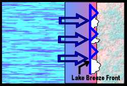
You should be able to detect the temperature difference and the wind shift at the frontal boundary without the aid of instruments. On the land side of the front, the air is warm, and winds are generally light and usually variable. On the other side, the air is distinctly cooler with wind blowing off the water, often being much gustier. Later in the day, the differences may become less apparent with the wind shifting to parallel the coastline rather than coming in perpendicular to it. (This is due to the influence of the Coriolis effect. Thus, with the lake to your right, the wind should be at your back.) The front may also be defined by a line of cumulus clouds along it, which can grow into thunderstorms under certain conditions.
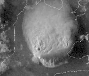
I had the opportunity to frequently experience the contrasts on opposite sides of the lake breeze front during a field study in 1970. We were investigating the lake breeze character and its distance of penetration along the western shores of Lake Erie for a climate study of air pollution dispersion characteristics. We had positioned our monitoring equipment such that the front would travel inland past several of the stations but infrequently go past all of them. Thus, as I moved inland from the lakeshore, I was able to feel the difference between the two air masses. On several occasions, I was present at a station when the front passed by and could feel the changing conditions and see its distinct signature being written on the charts. Lake Breeze ThunderstormsThe lake breeze front can also trigger thunderstorms as the cold lake air pushes the warmer land air upward along the frontal boundary. Such storms can become severe, particularly when separate lake breeze fronts approach from opposite directions and produce a strong convergence zone between them. Converging air masses can only go upward, and such strong upward motions are very conducive for thundershower and thunderstorm formation. The region of southwestern Ontario along a line from Detroit to Toronto is bounded by Lake Huron to the north and Lake Erie to the south. Here lake breezes frequently move off each lake during hot weather, and the breeze fronts converge somewhere over the region. Recently, meteorologists participating in a field study dubbed ELBOW (Effects of Lake Breezes on Weather) documented a severe storm event in July 1997 that was triggered by lake breezes flowing off Lakes Erie and Huron.
The preliminary results from Project ELBOW suggest that thunderstorm formation and severity associated with lake breeze fronts may be more significant than previously believed. This gives forecasters for the region another aspect for consideration during the warm season. [Further Information on Project ELBOW is available at: http://www.yorku.ca/research/blayer/ELBOW/cmosbull.htm and thunderstorm pictures from ELBOW can be found at: http://www.yorku.ca/research/blayer/ELBOW/elbowpix.html. ] While lake breezes can increase pollution levels and bred thunderstorms, they are usually welcomed for the relief from the intense heat and humidity of summer days they bring to residents of the Great Lakes basin. Learn More About Winds From These Relevant Books
|
||||||||||||||||||
 |
To Purchase Notecard, |
Now Available! Order Today! | |
 |
 |
NEW! Now |
The BC Weather Book: |