| Home | Welcome | What's New | Site Map | Glossary | Weather Doctor Amazon Store | Book Store | Accolades | Email Us |
 | ||||||||||||||||||||||||||||||||||||||||||
Weather Almanac for January 2000BLIZZARD!Most of the snow whitening the ground this morning fell lazily during the night, dry fluffy snowflakes forming a duvet over the sleeping city. By morning, the municipal snow plows had cleared the major streets sufficiently so that I was able to extract my car from the driveway and make the five-kilometre trek to the office. The snow that fell overnight came mostly from the region ahead of the storm's cyclonic centre, ahead of the warm front. At first light, we did not know that the worst of the storm's punch was yet to come. Yes, the forecast warned of blizzard conditions and a Winter Storm Warning was posted. But like those venturing forth in the eye of a hurricane, we allowed the brief respite of the warm sector of this storm to lull us all into a false sense of security. Most headed off to work and school with no thought of conditions in the hours ahead.
Just before noon, the latent fury of the storm was unleashed. The cold front rushed quickly over us; the temperature plummeted, first ten, then twenty degrees below freezing. The wind, shifting from moderate southwesterly to gusty northern gales in a heart's beat, whipped the newly fallen snow back into the air. Some of the airborne snow quickly crashed back down, only to be recaptured in the turbulent gusts and sent further on their way. Snow drifts began to crest on the snowy sea and from them ice crystals hissed as they ran across the snow surface like an army of beetles fleeing the light. Other snow flakes and ice crystals rose high into the sky on a journey to points unknown, far from their launch point. The massive, migrating population reduced the visibility to mere metres. Only when the wicked wind paused to recharge, did we catch a glimpse of the buildings across the courtyard. The quickly deteriorating conditions sent us home early. My usually short dash home became an odyssey as snow drifts marched across streets and the furious flurries of flying flakes made each intersection a nerve-wracking crossing of blind hope. After a forty-minute trip filled with detours, I arrived home to find my driveway drifted over with knee-deep snow — all that I had shoveled off it this morning plus new contributions from my neighbours' lawns and the curbside banks. But I, at last, was home and safe. Whereas the previous night had been a winter wonderland of light snowflakes dancing in the wind, this night a screaming banshee wind drove stinging, hard ice crystals against all that stood in its path. From inside, I heard the angry chatter of ice pellets racing across the attic roof. And around the corners of the house, the moaning wind sang a sorrowful blues. Blizzards are a time for rest, and who can argue with the wind. Technically, blizzards are more than just a heavy snowstorm. The snow that fell last night drowned the city in a sea of snow, but the mild temperatures and gentle breezes did not qualify the storm for blizzard status.
True blizzard conditions occur, according to the US National Weather Service, when winter storm wind speeds exceed 35 mph (56 km/h) and visibility is reduced by falling or blowing snow to a quarter mile (400 m) or less. In addition, these conditions must last for at least three hours. A severe blizzard boasts winds in excess of 45 mph (72 km/h). There is no specific temperature criterion in the US definition, but blizzards commonly have air temperatures below 20 oF (–6.7 oC) and severe blizzards below 10 oF (–12.2 oC). The official Environment Canada definition for a blizzard is similar but there are also regional specifics. A blizzard, in general, is a winter storm with winds exceeding 40 km/h (25 mph) with visibility reduced by falling or blowing snow to less than a kilometre (0.625 miles) and lasting for at least three hours. All regional definitions contain the same wind speed and visibility criteria but differ in the required duration and add a temperature criterion.
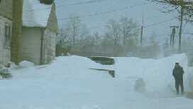
 Urban Blizzard |
||||||||||||||||||||||||||||||||||||||||||
 |
| Photo Courtesy of NOAA/US Dept of Commerce |
Blizzards with roots in Alberta Clippers and Colorado Lows forming east of the Rockies channel severe cold outbreaks from Arctic latitudes to as far south as Texas where they are known as Blue Northers. Snowfall may be may be very heavy in southern regions where arctic air combats tropical Gulf of Mexico air. Such storms may eventually paralyze the Missouri, Mississippi and Ohio River valleys, the Great Lakes and Atlantic Coast.
Colorado Lows may also move over the southern tier of US States only to gain added strength as they move offshore over the warm waters of the Gulf Stream. Newly reborn, these storms are called Hatteras Lows or Nor'Easters when they bring blizzard conditions to the Atlantic Coast from the Carolinas through New England to the Canadian Maritimes.
One unique form of blizzard strikes the southern and eastern shores of the Great Lakes. This brand of storm develops to the rear of intense low pressure systems and may persist for several days after the low has moved away, feeding off the cold air surging south. These lake-effect blizzards blow snow squalls onto the lee shores of the Great Lakes as the intensely cold arctic air mass picks up moisture while crosses the relatively warm lake waters. Where and when the snow is not falling, the arctic gales whip ground snow into the air, thus reducing visibility to near zero.
Lake blizzards often combine heavy snow squalls with days of blowing and drifting snow. During the Winter of 1976-77, Buffalo, New York experienced 40 straight days of lake-effect snow (not to mention scores more during the season). For many days that season, the city and surrounding region were paralyzed by blizzard conditions, whiteouts and huge snowdrifts.
In my blizzard, the first day of storm was the direct result of an approaching, intense low- pressure system crossing over the lower Great Lakes. But in its wake, a strong persistent flow of cold air was established on the eastern flank of a large Arctic air mass which extended from northwestern Ontario through Illinois. Lake squalls moving off the water of Lake Huron and Georgian Bay waxed and waned for several days before finally diminishing.
Winds howl like banshees loosed from arctic imprisonment, and snow fills the sky, a swarm of ermine moths stampeding under the windsangerscream whip. Those snow crystals reaching the ground hiss along the icy surface formed under the frigid boreal breath, the broad trough between frozen wave crests: snow dunes, snow drifts. As the winds howled outside and snow and ice crystals danced vigorously across the sky, I snuggled deeper into my cosy chair, sipping a hot chocolate. Enjoying the winter's rest, I wrote and napped and read. As I was about to doze off once again, my eyes captured the words of Henry David Thoreau, writing from Concord in 1853:
"All day a driving snow storm, imprisoning most, stopping the cars, blocking up the roads. No school to-day. I cannot see a house fifty rods off from my window through [it]; yet in midst of all I see a bird, probably a tree sparrow, partly blown, partly flying over the house to alight in a field. The snow penetrates through the smallest crevices under doors and side of windows."
For more on Lake Effect Snows
For excerpts from John Greenleaf Whittier's Snowbound
 |
To Purchase Notecard, |
Now Available! Order Today! | |
 |
 |
NEW! Now |
The BC Weather Book: |